Bythias

Last updated

Bythias was a town of ancient Thrace on the Bosphorus, inhabited during Roman times. [1]
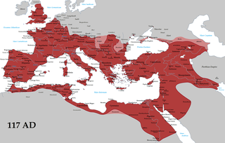
Roman Empire Period of Imperial Rome following the Roman Republic (27 BC–476 AD)

The Roman Empire was the post-Republican period of ancient Rome, consisting of large territorial holdings around the Mediterranean sea in Europe, North Africa and West Asia ruled by emperors. From the accession of Caesar Augustus to the military anarchy of the third century, it was a principate with Italy as metropole of the provinces and its city of Rome as sole capital. The Roman Empire was then ruled by multiple emperors and divided in a Western Roman Empire, based in Milan and later Ravenna, and an Eastern Roman Empire, based in Nicomedia and later Constantinople. Rome remained the nominal capital of both parts until 476 AD, when it sent the imperial insignia to Constantinople following the capture of Ravenna by the barbarians of Odoacer and the subsequent deposition of Romulus Augustus. The fall of the Western Roman Empire to Germanic kings, along with the hellenization of the Eastern Roman Empire into the Byzantine Empire, is conventionally used to mark the end of Ancient Rome and the beginning of the Middle Ages.

Its site is located near Kuruçeşme in European Turkey. [1] [2]

Kuruçeşme Neighborhood in Istanbul, Marmara, Turkey

Kuruçeşme is a neighborhood in Beşiktaş district of İstanbul, Turkey. It is on the European side of Bosphorous between the neighborhoods of Ortaköy and Arnavutköy.

Related Research Articles

Nausimachion was a coastal town of ancient Bithynia located on the Bosphorus.

Nausikleia was a coastal town of ancient Bithynia located on the Bosphorus.

Phiela or Phiale was a coastal town of ancient Bithynia located on the Bosphorus.

Boradion was a coastal town of ancient Bithynia located on the Bosphorus.

Palodes was a coastal town of ancient Bithynia located on the Bosphorus.

Amycus or Amykos was a coastal town of ancient Bithynia located on the Bosphorus.

Chelae or Chelai was a coastal town of ancient Bithynia located on the Bosphorus.

Myrileion was a town of ancient Thrace, inhabited during Roman times.

Phosphorus was a town of ancient Thrace, inhabited during Roman times.

Chalcaea was a town of ancient Thrace, inhabited during Roman times.

Kalos Agros was a town of ancient Thrace, inhabited during Roman times.

Pharmakia or Therapeia was a town of ancient Thrace, inhabited during Roman and Byzantine times.

Pitheci Portus was a town of ancient Thrace, inhabited during Roman times.

Kyparodes was a town of ancient Thrace, inhabited during Roman times.

Phidalia Petra was a town of ancient Thrace, inhabited during Roman and Byzantine times.

Pyrrhias Cyon was a town of ancient Thrace, inhabited during Roman times.

Chelae or Chelai, also called Philemporos, was a town of ancient Thrace on the Bosphorus, inhabited during Roman and Byzantine times.

Kalamos was a town of ancient Thrace on the Bosphorus, inhabited during Roman times.

Parabolos was a town of ancient Thrace on the Bosphorus, inhabited during Roman times.

Iasonion or Daphne was a town of ancient Thrace, inhabited during Roman and Byzantine times.

References

  1. 1 2 Richard Talbert, ed. (2000). Barrington Atlas of the Greek and Roman World . Princeton University Press. p. 53, and directory notes accompanying.
  2. Lund University. Digital Atlas of the Roman Empire.

Coordinates: 41°03′39″N29°02′07″E / 41.060799°N 29.035349°E / 41.060799; 29.035349

Geographic coordinate system Coordinate system

A geographic coordinate system is a coordinate system that enables every location on Earth to be specified by a set of numbers, letters or symbols. The coordinates are often chosen such that one of the numbers represents a vertical position and two or three of the numbers represent a horizontal position; alternatively, a geographic position may be expressed in a combined three-dimensional Cartesian vector. A common choice of coordinates is latitude, longitude and elevation. To specify a location on a plane requires a map projection.