The Tribune Tower is a 463-foot-tall (141 m), 36-floor neo-Gothic skyscraper located at 435 North Michigan Avenue in Chicago, Illinois, United States. Built between 1923 and 1925, the international design competition for the tower became a historic event in 20th-century architecture.

Michigan Avenue is a north-south street in Chicago which runs at 100 east on the Chicago grid. The northern end of the street is at Lake Shore Drive on the shore of Lake Michigan in the Gold Coast Historic District. The street's southern terminus is at Sibley Boulevard in the southern suburb of Dolton, though like many Chicago streets it exists in several disjointed segments.
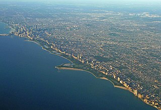
Lincoln Park is a 1,208-acre (489-hectare) park along Lake Michigan on the North Side of Chicago, Illinois. Named after US President Abraham Lincoln, it is the city's largest public park and stretches for seven miles (11 km) from Grand Avenue, on the south, to near Ardmore Avenue on the north, just north of the Lake Shore Drive terminus at Hollywood Avenue. Several museums and a zoo are located between North Avenue and Diversey Parkway in the eponymous neighborhood. Further to the north, the park is characterized by parkland, beaches, recreational areas, nature reserves, and harbors. To the south, there is a more narrow strip of beaches east of Lake Shore Drive, almost to downtown. With 20 million visitors per year, Lincoln Park is the second-most-visited city park in the United States, behind Central Park.

The Near South Side is a community area of Chicago, Illinois, United States, just south of the downtown central business district, the Loop. The Near South Side's boundaries are as follows: North—Roosevelt Road ; South—26th Street; West—Chicago River between Roosevelt and 18th Street, Clark Street between 18th Street and Cermak Road, Federal between Cermak Road and the Stevenson Expressway just south of 25th Street, and Clark Street again between the Stevenson and 26th Street; and East—Lake Michigan.

State Street is a large south-north street, also one of the main streets, in Chicago, Illinois, USA and its south suburbs. Its intersection with Madison Street has marked the base point for Chicago's address system since 1909. State begins in the north at North Avenue, the south end of Lincoln Park, runs south through the heart of the Chicago Loop, and ends at the southern city limits, intersecting 127th Street along the bank of the Little Calumet River. It resumes north of 137th Street in Riverdale and runs south intermittently through Chicago's south suburbs until terminating at New Monee Road in Crete, Illinois.

LaSalle Street is a major north-south street in Chicago named for Robert de La Salle, a 17th century French explorer of the Illinois Country. The portion that runs through the Chicago Loop is considered to be Chicago's financial district.
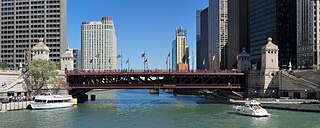
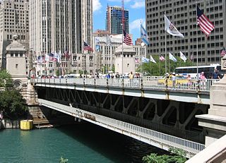
The DuSable Bridge is a bascule bridge that carries Michigan Avenue across the main stem of the Chicago River in downtown Chicago, Illinois, United States. The bridge was proposed in the early 20th century as part of a plan to link Chicago's south side and north side parks with a grand boulevard. Construction of the bridge started in 1918, it opened to traffic in 1920, and decorative work was completed in 1928. The bridge provides passage for vehicles and pedestrians on two levels. An example of a fixed trunnion bascule bridge, it may be raised to allow tall ships and boats to pass underneath. The bridge is included in the Michigan–Wacker Historic District and has been designated as a Chicago Landmark.
Richard Herman Driehaus was an American fund manager, businessman and philanthropist. He was the founder, chief investment officer, and chairman of Driehaus Capital Management LLC, based in Chicago.
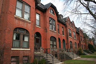
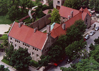
The McCormick Row House District is a group of houses located in the Lincoln Park community area in Chicago, Illinois, USA. It sits between East and West parts of DePaul University's Lincoln Park Campus and is independent from the school. They were built between 1884 and 1889 and used by the McCormick Theological Seminary to gain rental income. They were designed in the Queen Anne Style by the A. M. F. Colton and Son architects and joined the list of Chicago Landmarks May 4, 1971. The McCormick Row House District also lies within the boundaries of the Sheffield Historic District.

The Historic Michigan Boulevard District is a historic district in the Loop community area of Chicago in Cook County, Illinois, United States encompassing Michigan Avenue between 11th or Roosevelt Road, depending on the source, and Randolph Streets and named after the nearby Lake Michigan. It was designated a Chicago Landmark on February 27, 2002. The district includes numerous significant buildings on Michigan Avenue facing Grant Park. In addition, this section of Michigan Avenue includes the point recognized as the end of U.S. Route 66. This district is one of the world's best known one-sided streets rivalling Fifth Avenue in New York City and Edinburgh's Princes Street. It lies immediately south of the Michigan–Wacker Historic District and east of the Loop Retail Historic District.

The Chicago Avenue Pumping Station is a historic district contributing property in the Old Chicago Water Tower District landmark district. It is located on Michigan Avenue along the Magnificent Mile shopping district in the Near North Side community area of Chicago, Illinois. It is on the east side of Michigan Avenue opposite the Chicago Water Tower.
Pioneer Court is a plaza located near the junction of the Chicago River and Upper Michigan Avenue in Chicago's Magnificent Mile. It is believed to be the site of Jean Baptiste Point du Sable's original residence and trading post. In 1965, the plaza was built on the former site of his homestead as part of the construction of the Equitable Life Assurance Society of America building. The Jean Baptiste Point Du Sable Homesite was designated as a National Historic Landmark on May 11, 1976. John Kinzie, a prominent early settler, bought and expanded Point du Sable's post in 1800. The Plaza is bounded on the north by the Tribune Tower, on the east by 401 N. Michigan Avenue, on the south by the Chicago River, and on the west by Michigan Avenue, adjacent to the DuSable Bridge. In 2017, a newly designed Apple Inc. store was opened on the south side of the court, which created new levels linking down to the river.

Rush Street is a one-way street in the Near North Side community area of Chicago in Cook County, Illinois, United States. The street, which starts at the Chicago River between Wabash and North Michigan Avenues, runs directly north until it slants on a diagonal as it crosses Chicago Avenue then it continues to Cedar and State Streets, making it slightly less than a mile long. One lane also runs southbound from Ohio Street (600N) to Kinzie Street (400N) as part of a two-way street segment. It runs parallel to and one block west of the Magnificent Mile on the two-way traffic North Michigan Avenue, which runs at 100 east up to 950 north. The street, which is also one block east of the one-way southbound Wabash Avenue, formerly ran slightly further south to the Chicago River where over time various bridges connected it to the Loop, Chicago's central business district.
Chez Paul was a French restaurant in Chicago, Illinois. Established in 1945 by Paul Contos, Chez Paul became famous under Paul's son, Bill. When it was open, it was the oldest French restaurant in Chicago, and was only exceeded in prestige by Le Francais
The McCormick family of Chicago and Virginia is an American family of Scottish and Scotch-Irish descent that attained prominence and fortune starting with the invention of the McCormick Reaper, a machine that revolutionized agriculture and established the modern grain trade by beginning the mechanization of the harvesting of grain. Through the McCormick Harvesting Machine Company and later, the International Harvester Company and other investments, the McCormicks became one of the wealthiest families in America. The name became ubiquitous in agriculture starting in the 19th century and the press dubbed the McCormicks the "Reaper Kings". Later generations expanded into media and publishing, finance, and real estate. Various family members were well known as civic leaders. They are descended from an influential leader of modern agriculture, inventor Robert McCormick Jr. (1780–1846), and Mary Ann "Polly" Hall of Steeles Tavern, Virginia. The family is Presbyterian.
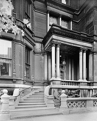
The Samuel M. Nickerson House, located at 40 East Erie Street in the Near North Side neighborhood of Chicago, Illinois, is a Chicago Landmark. It was designed by Edward J. Burling of the firm of Burling and Whitehouse and built for Samuel and Mathilda Nickerson in 1883. Samuel M. Nickerson was a prominent figure in the rising national banking industry, who was said to have owned at one point more national bank stock than anyone else in the United States.
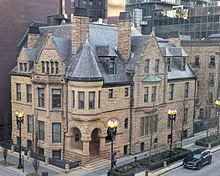
Prairie Avenue is a north–south street on the South Side of Chicago, which historically extended from 16th Street in the Near South Side to the city's southern limits and beyond. The street has a rich history from its origins as a major trail for horseback riders and carriages. During the last three decades of the 19th century, a six-block section of the street served as the residence of many of Chicago's elite families and an additional four-block section was also known for grand homes. The upper six-block section includes part of the historic Prairie Avenue District, which was declared a Chicago Landmark and added to the National Register of Historic Places.
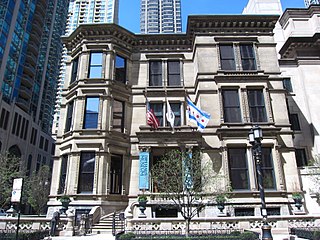
The Richard H. Driehaus Museum is a museum located at 40 East Erie Street on the Near North Side in Chicago, Illinois, near the Magnificent Mile. The museum is housed within the historic Samuel M. Nickerson House, the 1883 residence of a wealthy Chicago banker. Although the mansion has been restored, the Driehaus Museum does not re-create the Nickerson period but rather broadly interprets and displays the prevailing design, architecture, and decorating tastes of Gilded Age America and the art nouveau era in permanent and special exhibitions.