Calau Kalawa | |
|---|---|
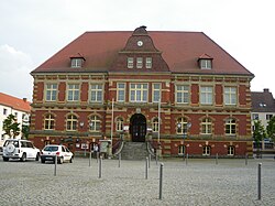 Town hall of Calau | |
 Coat of arms | |
Location of Calau within Oberspreewald-Lausitz district  | |
 Calau  Calau | |
| Coordinates: 51°44′45″N13°57′03″E / 51.74583°N 13.95083°E | |
| Country | Germany |
| State | Brandenburg |
| District | Oberspreewald-Lausitz |
| Subdivisions | Town of Calau and 11 Ortsteile |
| Government | |
| • Mayor (2023–31) | Marco Babenz [1] (Ind.) |
| Area | |
• Total | 162.59 km2 (62.78 sq mi) |
| Elevation | 93 m (305 ft) |
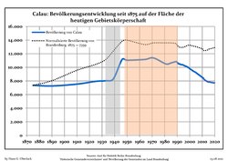
| Population (2022-12-31) [2] | |
• Total | 7,660 |
| • Density | 47/km2 (120/sq mi) |
| Time zone | UTC+01:00 (CET) |
| • Summer (DST) | UTC+02:00 (CEST) |
| Postal codes | 03205 |
| Dialling codes | 03541 |
| Vehicle registration | OSL, CA, SFB |
| Website | www.calau.de/ |
Calau (German pronunciation: [ˈkaːlaʊ] , Lower Sorbian : Kalawa, pronounced [ˈkalawa] ) is a small town in the Oberspreewald-Lausitz district, in southern Brandenburg, in eastern Germany. It is situated 14 km south of Lübbenau, and 27 km west of Cottbus. Calau is also called the home of the Kalauer.