
Chingford is a suburban town in east London, England, within the London Borough of Waltham Forest. The centre of Chingford is 9.2 miles (14.8 km) north-east of Charing Cross, with Waltham Abbey to the north, Woodford Green and Buckhurst Hill to the east, Walthamstow to the south, and Edmonton and Enfield to the west. It had a population of 70,583 at the 2021 census.

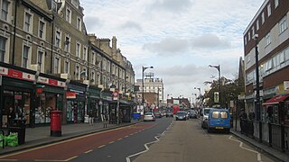
Leyton is a town in East London, England, within the London Borough of Waltham Forest. It borders Walthamstow to the north, Leytonstone to the east, and Stratford to the south, with Clapton, Hackney Wick and Homerton, across the River Lea, to the west. The area includes New Spitalfields Market, Leyton Orient Football Club, as well as part of the Queen Elizabeth Olympic Park. The town consists largely of terraced houses built between 1870 and 1910, interspersed with some modern housing estates. It is 6.2 miles (10 km) north-east of Charing Cross.

Stratford is a town in East London, England, within the London Borough of Newham. Part of the Lower Lea Valley, Stratford is situated 6 miles (9.7 km) east-northeast of Charing Cross, and includes the localities of Maryland and East Village.

The London Borough of Waltham Forest is an outer London borough formed in 1965 from the merger of the municipal boroughs of Leyton, Walthamstow and Chingford.

Leytonstone is an area in East London, England, within the London Borough of Waltham Forest. It adjoins Wanstead to the north-east, Forest Gate to the south-east, Stratford to the south-west, Leyton to the west, and Walthamstow to the north-west, and is 7 miles (11 km) north-east of Charing Cross.

Leyton is a London Underground station in Leyton, in the London Borough of Waltham Forest, East London. Located on Leyton High Road, adjacent to the A12, the station is on the Central line between Stratford and Leytonstone stations. It is in Travelcard zone 3.

Leytonstone High Road is a railway station in Leytonstone in the London Borough of Waltham Forest, on the Gospel Oak to Barking line, 9 miles 76 chains (16.0 km) down the line from Gospel Oak and situated between Leyton Midland Road and Wanstead Park. It has two platforms that are elevated approximately 20 feet (6 m) above ground level, each of which contains a metal shelter, covered but not completely enclosed. Ticket machines and Oyster validators are installed under the arch at the foot of the stairs.

Leyton Midland Road is a London Overground station in Leyton of the London Borough of Waltham Forest. It is on the Gospel Oak to Barking line, 9 miles 18 chains (14.8 km) down the line from Gospel Oak and situated between Walthamstow Queen's Road and Leytonstone High Road stations in Travelcard Zone 3. It is the closest railway station to Bakers Arms.

Leytonstone is a London Underground station in Leytonstone in the London Borough of Waltham Forest, east London. It is on the Central line, on the boundary of Zones 3 and 4. Towards Central London, the next station is Leyton, while going east from Leytonstone, the line divides into two branches. On the direct route to Woodford and Epping the next stop is Snaresbrook, and on the Hainault loop it is Wanstead. The station is close to Whipps Cross University Hospital. It is a terminus for some services and returns westbound.
Forest Gate is a district in the London Borough of Newham, East London, England. It is located 7 miles (11 km) northeast of Charing Cross.

Leyton and Wanstead is a constituency in Greater London created in 1997 and represented in the House of Commons of the UK Parliament since 2024 by Calvin Bailey of the Labour Party.

Leyton was a local government district in southwest Essex, England, from 1873 to 1965. It included the neighbourhoods of Leyton, Leytonstone and Cann Hall. It was suburban to London, forming part of the London postal district and Metropolitan Police District. It now forms the southernmost part of the London Borough of Waltham Forest in Greater London.

Wanstead Flats is the southernmost portion of Epping Forest, in Leytonstone and Wanstead, London. The flats and by extension the forest ends at Forest Gate directly to the south. It now falls wholly within the boundaries of the London Boroughs of Redbridge and Waltham Forest, though until 1994 two parts of it were in the London Borough of Newham: one of these was the section between Aldersbrook Road and Capel Road east of the junction between Aldersbrook Road and St Margaret's Road, whilst the other was the strip running along Capel Road between its junctions with Centre Road and Ridley Road. As part of Epping Forest, the Flats is managed by the City of London Corporation.

Whipps Cross is an area of the districts of Leytonstone and Walthamstow in the London Borough of Waltham Forest in East London, England. It is most famous for Whipps Cross University Hospital. Prior to 1965, it was located in the historic county of Essex.
Leyton was a parliamentary constituency in the United Kingdom, centred on the town of Leyton in North-East London. It returned one Member of Parliament (MP) to the House of Commons of the Parliament of the United Kingdom, elected by the first-past-the-post system.

Woodford is a town in East London, England, within the London Borough of Redbridge. It is located 9.5 miles (15.3 km) north-east of Charing Cross. Woodford historically formed an ancient parish in the county of Essex. It contained a string of agrarian villages and was part of Epping Forest. From about 1700 onwards, it became a place of residence for affluent people who had business in London; this wealth, together with its elevated position, has led to it being called the Geographical and social high point of East London. Woodford was suburban to London and after being combined with Wanstead in 1934 it was incorporated as a municipal borough in 1937. It has formed part of Greater London since 1965 and comprises the neighbourhoods of Woodford Green, Woodford Bridge, Woodford Wells and South Woodford. The area is served by two stations on the Central line of the London Underground: Woodford and South Woodford.

Our Lady of Lourdes church is the Catholic parish church for Wanstead in the London Borough of Redbridge and parts of Leytonstone in the London Borough of Waltham Forest. The parish is part of the Diocese of Brentwood.

Bushwood is an area in the north of Leytonstone in East London; determined by the curved boundary of the road called Bushwood along the edge of Wanstead Flats, Lister Road to the south and High Road, Leytonstone to the west. The area has the Browning Road Conservation Area, that contains what remains of the historic hamlet of Leyton-atte-stone.
Holloway Down was a village, historically in Essex and now part of Leytonstone in the London Borough of Waltham Forest. The village was sited at the junction of Union Lane and Leytonstone Road It is most notable as the location of the West Ham Union Workhouse, While the village has been replaced by Victorian terraces and shops, buildings from the workhouse remain; which have been converted into housing and part of North East London NHS Foundation Trust.
The Epping Forest Centenary Walk is a long-distance footpath in England, connecting East London to Epping Forest. It is also known as Epping Forest Big Walk. The 15 mi (24 km) path runs from Manor Park to Epping Forest using, where possible, green corridors.


