
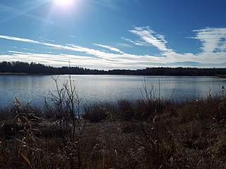
Kenosee Lake is a closed-basin lake in the south-east corner of the Canadian province of Saskatchewan. The lake lies in Moose Mountain Provincial Park in the heart of the Moose Mountain Upland, a forested plateau that rises about 200 metres (660 ft) above the surrounding prairie.

Carrot River is a river in Western Canada in the north-eastern part Saskatchewan and the north-western part of Manitoba. The outlet of Wakaw Lake in Saskatchewan marks the beginning of the Carrot River and, from there, it flows north-east past several communities and Indian reserves until it joins the Saskatchewan River in the Cumberland Delta in Manitoba. The river's mouth is west and upstream of the Pasquia River and The Pas on the Saskatchewan River.

Moose Mountain Provincial Park is a provincial park, in south-eastern Saskatchewan about 24 kilometres (15 mi) north of the town of Carlyle on the Moose Mountain Upland. It is one of Saskatchewan's few parks with a community inside the park as there are several subdivisions with both year-round and seasonal residents. The village of Kenosee Lake is completely surrounded by the park but is not part of the park.

Cannington Lake, also known as Cannington Lake Resort, is a hamlet within the Rural Municipality of Moose Mountain No. 63 in the Canadian province of Saskatchewan at the north-east corner of Cannington Lake. Listed as a designated place by Statistics Canada, the hamlet had a population of 0 in the Canada 2011 Census.
Beaver Lake is a lake in the south-eastern portion of the Canadian province of Saskatchewan, just north of the community of Kenosee Lake in Moose Mountain Provincial Park.

Narrow Hills Provincial Park is a northern boreal forest provincial recreational park in the Canadian province of Saskatchewan. It is located in a hilly plateau called the Cub Hills and contains several recreational facilities and over 25 accessible lakes within its boundaries. The geographical features of the park, including the lakes, valleys, and lowlands were formed over 10,000 years ago during the last ice age. The town of Smeaton is the closest community and it is located 70 kilometres (43 mi) to the south.

The Rural Municipality of Moose Mountain No. 63 is a rural municipality (RM) in the Canadian province of Saskatchewan within Census Division No. 1 and SARM Division No. 1. It is located in the south-east portion of the province.
Moose Mountain Upland, Moose Mountain Uplands, or commonly Moose Mountain, is a hilly plateau located in the south-east corner of the Canadian province of Saskatchewan, that covers an area of about 13,000 square kilometres (5,000 sq mi). The upland rises about 200 metres (660 ft) above the broad, flat prairie which is about 600 metres (2,000 ft) above sea level. The highest peak is "Moose Mountain" at 830 metres (2,720 ft) above sea level. The upland was named Moose Mountain because of the large number of moose that lived in the area. When it was originally used by fur traders, Métis, and the Indigenous peoples, the plateau was called Montagne a la Bosse, which is French for "The Mountain of the Bump or Knob".
Upper Fishing Lake is a lake in the east-central part of the Canadian province of Saskatchewan in Narrow Hills Provincial Park. It is situated in a glacier-formed valley in the Cub Hills and the boreal forest ecozone of Canada. It is north-west of the larger Lower Fishing Lake along the course of Caribou Creek and is accessed from the Hanson Lake Road.

Good Spirit Lake is a lake on the eastern side of the Canadian province of Saskatchewan. It is a shallow lake notable for its naturally sandy beaches, parks, and sand dunes. One of Saskatchewan's six founding provincial parks, Good Spirit Lake Provincial Park, surrounds the western and southern shores of the lake. The lake is in the RM of Good Lake No. 274 and Yorkton, 48 kilometres (30 mi) to the south, is the nearest city. The hamlets of Burgis Beach and Canora Beach — the only two communities on the lake — are located on the eastern shore. The southern shore of the lake is accessed from Highway 229 and the northern shore is accessed from Highway 746. Highway 47 runs north to south west of the lake and Good Spirit Lake Provincial Park.

Yorkton Creek, formally known as Little Whitesand River, is a river in the south-east region of the Canadian province of Saskatchewan. The river begins at Leech Lake, south of Yorkton, and flows north into the Whitesand River. The Whitesand River flows east into the Assiniboine River, which is a major tributary of the Red River. While Yorkton Creek begins at Leech Lake, its main tributary, Crescent Creek, has its headwaters in the Beaver Hills to the west.
Crescent Creek is a river in the south-east region of the Canadian province of Saskatchewan. The river begins in the Beaver Hills and flows in an easterly direction into Crescent Lake. Crescent Creek is a tributary of Yorkton Creek, which flows north into the Whitesand River–a tributary of the Assiniboine River.
York Lake, formally known as Pebble Lake, is a lake in the south-east region of the Canadian province of Saskatchewan. It is a shallow, narrow lake located about 5 kilometres (3.1 mi) south of the city of Yorkton in the Prairie Pothole Region of North America, which extends throughout three Canadian provinces and five U.S. states, and within Palliser's Triangle and the Great Plains ecoregion of Canada.

Christopher Lake is a recreational lake in the boreal forest ecozone in the Canadian province of Saskatchewan. It is located south-east of Emma Lake and Great Blue Heron Provincial Park in the central part of the province in the District of Lakeland No. 521. Access to Christopher Lake is from Highways 953 and 263 and it is about 42 km (26 mi) north of the city of Prince Albert.
Fife Lake is a fresh water prairie lake in the Canadian province of Saskatchewan. It is in the south-central part of the province at the eastern end of the Wood Mountain Hills. The entire lake and its shoreline is designated an Important Bird Area (IBA) of Canada to protect the nationally endangered piping plover. While there are no communities along the lake's shore, there is a park and campground at the southern end. Nearby communities include Fife Lake, Rockglen, and Lisieux. Access is from Highway 18.
Lucien Lake is a small recreational lake in the Canadian province of Saskatchewan. It is located in the RM of Three Lakes No. 400 in the aspen parkland ecoregion of Canada. On the lake's south-eastern shore is a regional park and to the east of that is the village of Middle Lake. Along the western shore are houses and Prairie Sky Resort campground. Access to the lake and its amenities is from Highway 777, which connects to Highway 20.
Culdesac Lake is a lake in the Canadian provinces of Saskatchewan and Manitoba. It is situated in the Saskatchewan River Delta and is in the Mid-Boreal Lowland ecoregion. It is surrounded by muskeg and boreal forest. Its primary inflow is from a channel connected to Culdesac River, which is a tributary of Carrot River. An outlet from the eastern end of Culdesac Lake connects it to the Pasquia River — a tributary of the Saskatchewan River. The lake falls within the Cumberland Marshes Important Bird Area of Canada.
Ness Lakes are a group of five interconnected lakes — the largest of which is Ness Lake — in the Canadian province of Saskatchewan. They are in the Rural Municipality of Big River No. 555 at the western end of the Waskesiu Hills in the boreal forest ecozone of Canada. The western boundary of Prince Albert National Park is directly to the east and the town of Big River is about 15 kilometres (9.3 mi) to the south-west. Access to the lakes is from Nesslin Lake Road, which branches off of Highway 922.

Overflowing River is a river in the Canadian provinces of Manitoba and Saskatchewan. It begins in Saskatchewan at Overflow Lake in the Pasquia Provincial Forest and flows in a generally eastward direction into Manitoba and then Lake Winnipegosis. The river traverses boreal forests and muskeg in the Boreal Plains Ecozone, moving from the Mid-Boreal Upland of the Pasquia Hills east to the Mid-Boreal Lowland.
Melfort Creek, originally known as Stoney Creek, is a river in the Canadian province of Saskatchewan. It is in the aspen parkland ecozone and flows through the "most productive farmland areas in Canada, the Carrot River Valley, a territory that has never known drought or severe crop failure". The river begins at Eagle Lake and flows north where it meets the Carrot River in the Rural Municipality of Willow Creek No. 458. The Carrot River is a tributary of the Saskatchewan River within the Nelson River drainage basin. Along Melfort Creek's course are two reservoirs and the city of Melfort.


