
The West Midlands is a ceremonial county, metropolitan county and combined authority area in west-central England with a 2019 estimated population of 2,928,592. This makes it the second most populous county in England after Greater London. It was created in 1974 under the Local Government Act 1972 to cover parts of Staffordshire, Worcestershire and Warwickshire. The county is a NUTS 2 region within a wider NUTS 1 region of the same name. It covers seven metropolitan boroughs: Birmingham, Coventry, Wolverhampton, Dudley, Sandwell, Solihull and Walsall.

Staffordshire is a landlocked county in the West Midlands of England. It borders Cheshire to the northwest, Derbyshire and Leicestershire to the east, Warwickshire to the southeast, the West Midlands County and Worcestershire to the south, and Shropshire to the west.
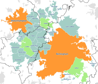
The West Midlands conurbation is the large conurbation that includes the cities of Birmingham and Wolverhampton and the towns of Sutton Coldfield, Dudley, Walsall, West Bromwich, Solihull, Stourbridge and Halesowen in the English West Midlands.

Cannock is a town located in the county of Staffordshire. It is the administrative centre of the Cannock Chase district, and as of the 2011 census, it has a population of 29,018. It is one of the most populous towns in the district of Cannock Chase.

Rugeley is an industrial and market town in Cannock Chase District in Staffordshire, England.

The Metropolitan Borough of Walsall is a metropolitan borough in the West Midlands, England. It is named after its largest settlement, Walsall, but covers a larger area which also includes Aldridge, Bloxwich, Brownhills, Darlaston, Pelsall and Willenhall. It also serves as the post town for nearby Cannock Chase District and Lichfield District respectively.

Hednesford is a historic market town within Cannock Chase district of Staffordshire, England. Hednesford adjoins The Chase to the north, with the town of Cannock 1.2 miles (1.9 km) to the south. It is also 4.6 miles (7.4 km) southwest of Rugeley.
The West Midlands region straddles the historic borders between the counties of Warwickshire, Staffordshire in the north, and Worcestershire in the south.
The Nottingham Built-up Area (BUA), Nottingham Urban Area, or Greater Nottingham is an area of land defined by the Office for National Statistics as which is built upon, with nearby areas linked if within 200 metres - see the List of urban areas in the United Kingdom article for a broader definition. It consists of the city of Nottingham and the adjoining urban areas of Nottinghamshire and Derbyshire, in the East Midlands of England. It had a total population of 729,977 at the time of the 2011 census. This was an increase of almost 10% since the 2001 census recorded population of 666,358, due to population increases, reductions and several new sub-divisions.

The Chase Line is a suburban railway line in the West Midlands region of England. It runs from its southern terminus, Birmingham New Street, to Walsall, and then Rugeley in Staffordshire, where it joins the Trent Valley Line. The name of the line refers to Cannock Chase which it runs through at its northern end.

Walsall railway station is the principal railway station of Walsall, West Midlands, England and situated in the heart of the town. It is operated by West Midlands Trains, with services provided by West Midlands Railway and from 2019, London Northwestern Railway operate a service from Rugeley to London Euston that calls at the station. The main entrance is situated inside the Saddlers Shopping Centre.
The Leicester Urban Area or Leicester Built Up Area is an urban agglomeration defined by the Office of National Statistics (ONS), centred on the City of Leicester in the English Midlands. With a population of 508,916 at the time of the 2011 census, the Built Up Area is the eleventh largest in England and thirteenth largest in the United Kingdom. It comprises Leicester itself and its suburbs, all of which are contiguous with, or situated in close proximity to, the city.

Hednesford railway station serves the town of Hednesford in Staffordshire, England. The station, and all trains serving it, are operated by West Midlands Railway.
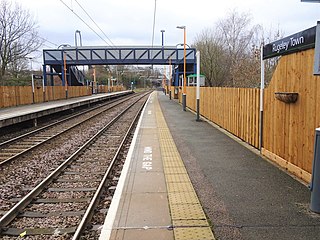
Rugeley Town railway station serves the town of Rugeley, Staffordshire, England. The station is operated by West Midlands Railway, with services operated by West Midlands Railway and London Northwestern Railway. The station is situated around half a mile from Rugeley town centre. The station is located in Wharf Road.

The Newport Built-up area is an area of land defined by the United Kingdom Office for National Statistics (ONS) for population monitoring purposes. It is an urban conurbation and is not coterminous with the city boundaries. It consists of the urban area centred on Newport as well as contiguous settlements in the eastern and western valleys extending north of the city – including Cwmbran, Pontypool, Risca, Abercarn and Blackwood. It does however exclude physically detached urban areas within the city boundaries, such as Marshfield.

Chadsmoor is an urban settlement within Cannock Chase District in the County of Staffordshire, England and lies between the wards of Cannock and Hednesford in South Staffordshire.

The Derby Built-up Area (BUA) or Derby Urban Area is an area including Derby and adjoining built-up districts of Derbyshire, in the East Midlands of England, including Borrowash and Duffield. The Office for National Statistics defines an urban area as one which is built upon, with nearby areas linked if within 200 metres.

The Cannock Chase Railways were mineral lines which served the collieries and many parts of Staffordshire. The branch lines and sidings branched off the local mainlines including the Grand Junction Railway, Chase Line, South Staffordshire Line and Rugby–Birmingham–Stafford line. The main junction on the railways was Norton Junction. This junction connected the lines from Walsall and Hednesford to Wolverhampton and Rugeley Trent Valley for the local collieries and the mines in the towns of Brownhills, Burntwood, Chasetown, Penkridge and Cannock.
