The Gulf of St. Lawrence fringes the shores of the provinces of Quebec, New Brunswick, Nova Scotia, Prince Edward Island, Newfoundland and Labrador, in Canada, plus the islands Saint-Pierre and Miquelon, possessions of France, in North America.

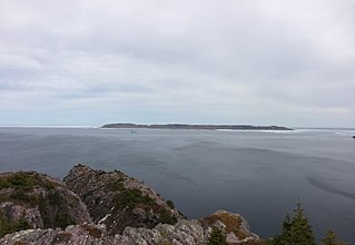
The Strait of Belle Isle is a waterway in eastern Canada, that separates Labrador from the island of Newfoundland, in the province of Newfoundland and Labrador.
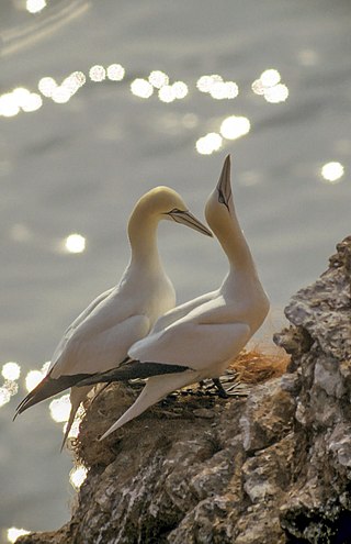
Gannets are seabirds comprising the genus Morus in the family Sulidae, closely related to boobies. They are known as 'solan' or 'solan goose' in Scotland. A common misconception is that the Scottish name is 'guga' but this is the Gaelic name referring to the chicks only.

Fitzgerald Marine Reserve is a marine reserve in California on the Pacific Ocean, located just north of Pillar Point Harbor and Mavericks in the San Mateo County community of Moss Beach. Moss Beach is located approximately 20 miles (32 km) south of San Francisco and 50 miles (80 km) north of Santa Cruz. The reserve is a 32-acre (0.13 km2) holding which extends from Montara light station at the north to Pillar Point on the south. The reserve consists of a three-mile stretch of beach, tidepool habitat, marsh, erosive bluffs, clifftop trail and cypress and eucalyptus forests. The property is owned by the State of California and managed by San Mateo County as a county park and nature preserve. The reserve is administratively assigned to be part of the Monterey Bay National Marine Sanctuary. Adjacent to and possibly within the reserve is an endangered species of butterfly, the San Bruno elfin butterfly.

Cape Spear is a headland located on the Avalon Peninsula of Newfoundland near St. John's in the Canadian province of Newfoundland and Labrador. At a longitude of 52°37' W, it is the easternmost point in Canada and North America, excluding Greenland.

The Australasian gannet, also known as the Australian gannet or tākapu, is a large seabird of the booby and gannet family, Sulidae. Adults are mostly white, with black flight feathers at the wingtips and lining the trailing edge of the wing. The central tail feathers are also black. The head is tinged buff-yellow, with a pearly grey bill edged in dark grey or black, and blue-rimmed eyes. Young birds have mottled plumage in their first year, dark above and light below. The head is an intermediate mottled grey, with a dark bill. The birds gradually acquire more white in subsequent seasons until they reach maturity after five years.

Cape Kidnappers, known in Māori as Te Kauwae-a-Māui and officially gazetted as Cape Kidnappers / Te Kauwae-a-Māui, is a headland at the southeastern extremity of Hawke's Bay on the east coast of New Zealand's North Island and sits at the end of an 8 kilometres (5.0 mi) peninsula which protrudes into the Pacific Ocean. It is 20 kilometres (12 mi) south-east of the city of Napier. Access to the cape by road stops at Clifton, which is the departure point for many tourists visiting the gannet colony. The Cape Kidnappers Golf Course lies between the headland and the nearby coastal community of Te Awanga.

Placentia is a town located in the Canadian province of Newfoundland and Labrador. It consists of the amalgamated communities of Placentia ("Townside"), Southeast Placentia, Freshwater, Dunville and Jerseyside and also includes the Argentia Industrial Park.
Baccalieu Island or Bacalhoo Island is a 5 km2 uninhabited island at the northern extremities of Conception Bay in Subdivision 1G, near the community of Red Head Cove, Newfoundland and Labrador, Canada. It is separated from the island of Newfoundland by Baccalieu Tickle, a small strait and an abundant fishing ground. The island has some trees but is mostly rocky.

Funk Island is a small, barren, isolated, uninhabited island approximately 65 kilometres (40 mi) northeast of Musgrave Harbour, Newfoundland, Canada.

The East Coast Trail (ECT) is a long-distance coastal footpath located in the Canadian province of Newfoundland and Labrador. It is a developed trail over 336 kilometres (209 mi) long, the creation of which began in 1994. It is made up of 25 linked wilderness paths and passes through more than 30 communities. It was named one of the best adventure destinations by National Geographic in 2012 and is extended and improved yearly.

Witless Bay Ecological Reserve is an ecological preserve close to St. John's, Newfoundland and Labrador, Canada. The Witless Bay Ecological Reserve consists of four islands: Gull Island, Green Island, Great Island, and Pee Pee Island. Immense numbers of birds nest on these islands during the seabird breeding season, roughly from 1 April through 1 September.
Cape Freels is a headland on the island of Newfoundland, in the province of Newfoundland and Labrador, Canada, and the location of a community of the same name. This cape, located at the northern extremity of Bonavista Bay, is not to be confused with another Cape Freels which is located at the southern extremity of the Avalon Peninsula of Newfoundland.
Baccalieu Island Ecological Reserve is a wildlife reserve located on an island off the northeastern tip of Bay de Verde Peninsula of Newfoundland.

The Cape Shore is a region on the southwestern portion of the Avalon Peninsula on the island of Newfoundland, Canada.

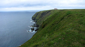
The headland of Cape St. Mary's is located at the southern tip of the south-western arm of the Avalon Peninsula of the island of Newfoundland in the Canadian province of Newfoundland and Labrador.

Mistaken Point Ecological Reserve is a wilderness area and a UNESCO World Heritage Site located at the southeastern tip of Newfoundland's Avalon Peninsula in the Canadian province of Newfoundland and Labrador. The reserve is home to the namesake Mistaken Point Formation, which contains one of the most diverse and well-preserved collections of Precambrian fossils in the world. Ediacaran fossils discovered at the site constitute the oldest known remnants of multicellular life on Earth.

South Avalon-Burin oceanic barrens is a taiga ecoregion located within the Canadian province of Newfoundland and Labrador and the French overseas collectivity of Saint Pierre and Miquelon. It is defined by the World Wildlife Fund (WWF) categorization system as inhabiting the southern headlands of the Avalon and Burin Peninsulas along the southeastern coast of Newfoundland.

The Rochers aux Oiseaux are an uninhabited archipelago in Quebec, Canada, located in the Gulf of St. Lawrence off the Magdalen Islands. The islands and the surrounding marine area are a migratory bird sanctuary known as the Rochers-aux-Oiseaux Bird Sanctuary, owned by the Canadian Coast Guard and home to a large colony of Northern gannets.