
Carloggas is a hamlet in the parish of Mawgan-in-Pydar, Cornwall, England. [1] [2]
There is also a hamlet in the parish of St Stephen-in-Brannel called Carloggas. [3] [4]
Carloggas is a hamlet in the parish of Mawgan-in-Pydar, Cornwall, England. [1] [2]
There is also a hamlet in the parish of St Stephen-in-Brannel called Carloggas. [3] [4]
Brocton is a hamlet in the parish of St Breock, Cornwall, England, UK.

Burlawn is a hamlet in the parish of St Breock, Cornwall, England, UK.

Carluddon is a hamlet north of St Austell and southeast of Stenalees in Cornwall, England. It is in the civil parish of Treverbyn.
Clerkenwater is a hamlet in the parish of Helland, Cornwall, England. Clerkenwater is situated 1.2 miles (1.9 km) north of Bodmin.

Coldvreath is a hamlet south-southwest of Roche in Cornwall, England. It is in the civil parish of Roche.

Demelza is a hamlet in the parish of St Wenn, Cornwall, England, UK. Demelza is situated 1 mile (1.6 km) south-east of St Wenn and lies at around 114 metres (374 ft) above sea level.
Edmonton is a hamlet west of Wadebridge in Cornwall, England. It is in the civil parish of St Breock.
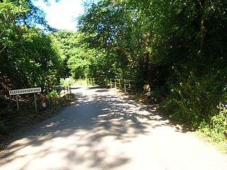
Fletchersbridge is a hamlet about 2 miles (3.2 km) east-south-east of Bodmin in Cornwall, England. in the valley of the River Fowey. Fletchersbridge lies at around 47 metres (154 ft) above sea level and is in the civil parish of Bodmin.
Garker is a hamlet situated 3 miles (4.8 km) north-east of St Austell in Cornwall, England. Garker lies close to the western edge of the Eden Project visitor attraction. Garker is in the civil parish of Carlyon.
Inchs or Inches is a hamlet in the parish of Withiel, Cornwall, England.
Lane-end is a hamlet in the parish of Egloshayle, Cornwall, England. It is in the civil parish of St Mabyn
Merry Meeting is a hamlet in the valley of the River Camel and in the parish of Blisland, Cornwall, England.

Mountjoy is a hamlet in the civil parish of Colan in Cornwall, England. It is on the A392 road, east of Quintrell Downs.
Mulberry is a hamlet in the parish of Lanivet, Cornwall, England.
Penmayne is a hamlet next to Splatt in the civil parish of St Minver Lowlands in north Cornwall, England, UK.
Pennytinney is a hamlet in the parish of St Kew, Cornwall, England, UK.
Penpont is a hamlet in the parish of St Breward, in north Cornwall, England, UK, in the Camel Valley.
Redmoor is a hamlet in Cornwall, England, United Kingdom.
Rumford is a hamlet in Cornwall, England. Rumford is in the civil parish of St Ervan. The telephone area code for Rumford is 01841.

Cocks is a hamlet in the parish of Perranzabuloe in Cornwall, England. Cocks is southeast of Perranporth.
| Unitary authorities | |
|---|---|
| Major settlements |
|
| Rivers | |
| Topics | |
Coordinates: 50°26′54″N4°59′56″W / 50.4483485°N 4.999004°W
| | This Cornwall location article is a stub. You can help Wikipedia by expanding it. |