Carrieton

Last updated

Carrieton
South Australia
Carrieton SA.jpg
Carrieton Memorial hall and council office.
Australia South Australia location map.svg
Red pog.svg
Carrieton
Coordinates 32°25′34″S138°31′44″E / 32.426072°S 138.529015°E / -32.426072; 138.529015 Coordinates: 32°25′34″S138°31′44″E / 32.426072°S 138.529015°E / -32.426072; 138.529015 [1]
Population51 (2016 census) [2] [lower-alpha 1]
Established10 April 1879 (town)
16 December 1999 (locality) [4] [5]
Postcode(s) 5432 [6]
Elevation440 m (1,444 ft)[ citation needed ]
Time zone ACST (UTC+9:30)
 • Summer (DST) ACST (UTC+10:30)
Location327.8 km (204 mi) N of Adelaide
LGA(s) District Council of Orroroo Carrieton [1]
Region Yorke and Mid North [1]
County Dalhousie [1]
State electorate(s) Stuart [7]
Federal division(s) Grey [8]
Mean max temp [9] Mean min temp [9] Annual rainfall [9]
25.2 °C
77 °F
10.6 °C
51 °F
308.6 mm
12.1 in
Localities around Carrieton:
Moockra Yanyarrie Belton
Moockra Carrieton Belton
Johnburgh
Moockra Eurelia Eurelia
FootnotesAdjoining localities [1]

Carrieton is a small town situated in the Flinders Ranges of South Australia. It is located between the towns of Orroroo to the south and Cradock to the north.

Contents

Originally opened in 1877 as Yanyarrie Whim, (Yanyarrie is in the local indigenous dialect "eagle feathers") with the construction of a post office, the settlement was renamed in 1888 as Carrieton, after the daughter of Governor Jervois, Lucy Caroline. [10]

Railways

The town was on the Peterborough–Quorn railway line which opened in December 1881, served by a Class 1 station. A large goods shed and fettler's cottage were also constructed.

Passenger services were discontinued during 1969, when the South Australian Railways withdrew the railcar service.[ citation needed ]

Declining rail traffic saw the gradual withdrawal of services on the railway, with the last station master being withdrawn on 1 July 1971. The railway was closed in 1981, and removed during 1986. [11]

Colonial history

Carrieton acquired a school (1882), a police station (1884), St Raphael's Roman Catholic Church (the large presbytery was built in 1889), a small Methodist Church (1882), an Anglican Church (1888) and the railway station, built in 1885 at a cost of £1,500. [12]

Recent history

The road was renamed the RM Williams Way in recognition of the area where R. M. Williams had many associations. Carrieton is often referred to as 'Gum Greek' country. The town is serviced through a community general store, hotel, post office, and accommodation, and it is a part of the District Council of Orroroo Carrieton.

Recently, after large downpours in January 2020, many of the creeks surrounding Carrieton were demolished. [13] The bridge over Yanyarrie Creek 10 km north of Carrieton was especially damaged as huge slates of bitumen disappeared down the creek. Yanyarrie creek has since been repaired with a detour, after the first detour was ruined again by another flash flood a few weeks after the first one.[ citation needed ]

Carrieton Rodeo

Carrieton is home to the Carrieton Rodeo, an Australian Professional Rodeos Association event, held every year on Proclamation Day. It held its 60th anniversary meet on 28 December 2012. [14] [ failed verification ]

Related Research Articles

<span class="mw-page-title-main">Quorn, South Australia</span> Town in South Australia

Quorn is a small town and railhead in the Flinders Ranges in the north of South Australia, 39 kilometres (24 mi) northeast of Port Augusta. At the 2016 census, the locality had a population of 1,230, of which 1,131 lived in its town centre.

<span class="mw-page-title-main">Flinders Ranges Council</span> Local government area in South Australia

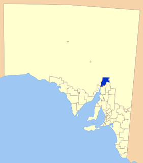
Flinders Ranges Council is a local government area (LGA) located in the Flinders Ranges of South Australia.

Marla is a town and locality in the Australian state of South Australia located in the state's north-west about 970 kilometres (600 mi) north-west of the state capital of Adelaide and about 402 kilometres (250 mi) south of the town of Alice Springs in the Northern Territory.

<span class="mw-page-title-main">Orroroo, South Australia</span> Town in South Australia

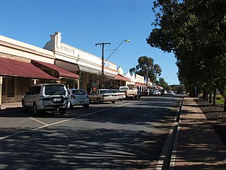
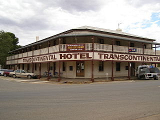
Orroroo is a town in the Yorke and Mid North region of South Australia. At the 2016 census, the locality of Orroroo had a population of 610 while its urban centre had a population of 537. The Wilmington-Ucolta Road passes through here, intersecting with the RM Williams Way which leads to the Birdsville and Oodnadatta Tracks. The Peterborough–Quorn railway line extended from Peterborough to Orroroo also in 1881 and Quorn in 1882, connecting with the new Central Australia Railway from Port Augusta. These railways have now been abandoned. Orroroo is situated near Goyder's Line, a line drawn up in 1865 by Surveyor General Goyder which he believed indicated the edge of the area suitable for agriculture.

<span class="mw-page-title-main">District Council of Orroroo Carrieton</span> Local government area in South Australia

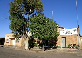
The District Council of Orroroo Carrieton is a local government area in the Yorke and Mid North region of South Australia. The principal towns are Orroroo and Carrieton; it also includes the localities of Belton, Black Rock, Coomooroo, Erskine, Eurelia, Johnburgh, Minburra, Pekina, Walloway, Yalpara and Yanyarrie, and part of Cradock, Hammond, Moockra, Morchard, Tarcowie and Yatina.

<span class="mw-page-title-main">Eurelia</span> Town in South Australia

Eurelia is a town and locality in the Australian state of South Australia located on the east side of the Flinders Ranges about 264 kilometres (164 mi) north of the state capital of Adelaide and about 20 kilometres (12 mi) from the municipal seat of Orroroo.

Bruce is a town and a locality in the Australian state of South Australia located about 278 kilometres (173 mi) north of the state capital of Adelaide.

<span class="mw-page-title-main">Black Rock, South Australia</span> Town in South Australia

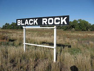
Black Rock is a hamlet in South Australia on the Black Rock Plains at the intersection of the south–north RM Williams Way (B80) between Jamestown and Orroroo and the west–east Wilmington–Ucolta Road (B56) to Peterborough, in the Mid North section of the state.

<span class="mw-page-title-main">Yatina</span> Town in South Australia

Yatina is a town and locality in the Australian state of South Australia located on the RM Williams Way about 222 kilometres (138 mi) north of the state capital of Adelaide and about 31 kilometres (19 mi) and 21 kilometres (13 mi) respectively from the municipal seats of Jamestown and Orroroo.

Pekina is a town and locality in the Mid North region of South Australia. The town is located in the District Council of Orroroo Carrieton local government area, 270 kilometres (170 mi) north of the state capital, Adelaide. At the 2006 census, Pekina and the surrounding area had a population of 172. The name of the town is thought to derive from the Aboriginal word for "creek water".

Hammond is a town and locality in the Australian state of South Australia located in the southern Flinders Ranges.

<span class="mw-page-title-main">District Council of Carrieton</span> Local government area in South Australia

The District Council of Carrieton was a local government area in South Australia, centred on the town of Carrieton from 1888 until 1997.

Belton is a rural locality in South Australia, located in the District Council of Orroroo Carrieton. It is traversed by the Carrieton-Barata Road, the Carrieton-Belton Road and the Weira Creek. The locality was established on 26 April 2013 in respect to “the long established local name.”

<span class="mw-page-title-main">Saltia, South Australia</span> Town in South Australia

Saltia is a locality in the Australian state of South Australia located on the western side of the Flinders Ranges about 279 kilometres (173 mi) north of the state capital of Adelaide and about 19 kilometres (12 mi) east of the city of Port Augusta.

Erskine is a locality in the Australian state of South Australia located about 250 kilometres (160 mi) north of the state capital of Adelaide and about 22 kilometres (14 mi) north-east of the municipal seat in Orroroo.

<span class="mw-page-title-main">Yalpara, South Australia</span> Suburb of District Council of Orroroo Carrieton, South Australia

Yalpara is a locality in the Australian state of South Australia located about 265 kilometres (165 mi) north of the state capital of Adelaide and about 29 kilometres (18 mi) north-east of the municipal seat in Orroroo.

Minburra is a locality in the Australian state of South Australia located about 265 kilometres (165 mi) north of the state capital of Adelaide and about 29 kilometres (18 mi) north-east of the municipal seat in Orroroo.

Moockra is a locality in the Australian state of South Australia located on the eastern side of the Flinders Ranges about 274 kilometres (170 mi) north of the state capital of Adelaide and about 47 kilometres (29 mi) north-east and 36 kilometres (22 mi) south-east respectively of the municipal seats of Melrose and Quorn.

<span class="mw-page-title-main">Johnburgh, South Australia</span> Suburb of District Council of Orroroo Carrieton, South Australia

Johnburgh is a town and a locality in the Australian state of South Australia located on the eastern side of the Flinders Ranges about 275 kilometres (171 mi) north of the state capital of Adelaide and about 32 kilometres (20 mi) north-east of the municipal seat of Orroroo.

Yanyarrie is a locality in the Australian state of South Australia located on the eastern side of the Flinders Ranges about 289 kilometres (180 mi) north of the state capital of Adelaide and about and 45 kilometres (28 mi) north of the municipal seat of Orroroo.

References

Notes
  1. For the 2016 census, the 'State Suburb of Carrieton' consisted of the locality of Carrieton and the part of the locality of Moockra which is located in the District Council of Orroroo Carrieton. [3]
Citations
  1. 1 2 3 4 5 "Search results for 'Carrieton, LOCB' with the following datasets selected – 'Suburbs and localities', 'Counties', 'Local Government Areas', 'SA Government Regions' and 'Gazetteer'". Location SA Map Viewer. Government of South Australia. Retrieved 28 October 2022.
  2. Australian Bureau of Statistics (27 June 2017). "State Suburb of Carrieton". 2016 Census QuickStats. Retrieved 14 February 2018. OOjs UI icon edit-ltr-progressive.svg
  3. "Search results for 'Moockra, LOCB' with the following datasets being selected - 'Suburbs and Localities', 'Local Government Areas' and 'Gazetteer'". Location SA Map Viewer. Government of South Australia. Retrieved 14 February 2018.
  4. "Untitled proclamation under the Crown Lands Consolidation Act re the Town of Carrieton" (PDF). The South Australian Government Gazette. South Australian Government. 10 April 1879. p. 1071. Retrieved 14 February 2018.
  5. "GEOGRAPHICAL NAMES ACT 1991, Notice to Assign Boundaries and Names to Places" (PDF), The South Australian Government Gazette: 3429, 16 December 1999, retrieved 14 February 2018
  6. Carrieton Postcode Australia Post
  7. "Electoral district of Stuart". Electoral Commission SA. Retrieved 12 February 2018.
  8. "Federal electoral division of Grey" (PDF). Australian Electoral Commission. Retrieved 12 February 2018.
  9. 1 2 3 "Climate statistics for HAWKER (nearest station)". Bureau of Meteorology. Retrieved 14 February 2018.
  10. Manning, G; 1990 Manning's Place Names of South Australia ISBN   05437687505
  11. Evans, J 2009; Proceed to Quorn Railmac Publications ISBN   978-1-86477-066-X
  12. Manning, Geoff. "Y" (PDF). South Australian Place names. State Library of South Australia. p. 6. Retrieved 11 December 2017.
  13. "Flood Event: January – February 2020". www.disasterassist.gov.au. Retrieved 23 October 2022.
  14. "Australian Professional Rodeo Association | Site Home". Archived from the original on 28 July 2013. Retrieved 8 July 2013.