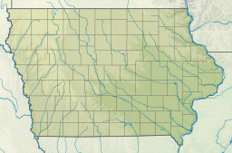
Council Bluffs is a city in and the county seat of Pottawattamie County, Iowa, United States. The population was 62,799 at the 2020 census, making it the state's tenth most populous city, and the most populous city in Southwest Iowa. The Omaha metropolitan region of which Council Bluffs is a part, is the 58th largest in the United States, with an estimated population of 983,969 (2023). It is located on the east bank of the Missouri River, across from Omaha, Nebraska. Until about 1853 Council Bluffs was known as Kanesville. Kanesville was the historic starting point of the Mormon Trail. Kanesville is also the northernmost anchor town of the other emigrant trails because there was a steam-powered boat which ferried the settlers' wagons and cattle across the Missouri River. In 1869, the first transcontinental railroad to California was connected to the existing U.S. rail network at Council Bluffs.

Carter Lake is a city in Pottawattamie County, Iowa, United States. A suburb of Omaha, Nebraska, it sits surrounding the south and west sides of the region's major airport, Eppley Airfield. It is separated from the rest of Iowa by the Missouri River, effectively making it an exclave. The population was 3,791 at the 2020 census.

North Omaha is a community area in Omaha, Nebraska, in the United States. It is bordered by Cuming and Dodge Streets on the south, Interstate 680 on the north, North 72nd Street on the west and the Missouri River and Carter Lake, Iowa on the east, as defined by the University of Nebraska at Omaha and the Omaha Chamber of Commerce.
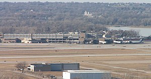
East Omaha is a geographically designated community located in Omaha, Nebraska. Located three miles (5 km) from downtown Omaha, East Omaha is the site of Eppley Airfield, Omaha's main airport, and Carter Lake. This area was Omaha's first annexation, joining the city in 1854. Originally separated from Omaha by the Missouri River, a large section of the area's land was dissected by a ruling from the U.S. Supreme Court in 1892. Today, 2,500 houses, a school, grocery stores and a church that made up the original town have been demolished and replaced by several government facilities, the Eppley Airfield, and more.
North Omaha, Nebraska has a recorded history spanning over 200 years, pre-dating the rest of Omaha, encompassing wildcat banks, ethnic enclaves, race riots and social change. North Omaha has roots back to 1812 and the founding of Fort Lisa. It includes the Mormon settlement of Cutler's Park and Winter Quarters in 1846, a lynching before the turn of the twentieth century, the thriving 24th Street community of the 1920s, the bustling development of its African-American community through the 1950s, a series of riots in the 1960s, and redevelopment in the late 20th and early 21st century.
Significant events in the history of North Omaha, Nebraska include the Pawnee, Otoe and Sioux nations; the African American community; Irish, Czech, and other European immigrants, and; several other populations. Several important settlements and towns were built in the area, as well as important social events that shaped the future of Omaha and the history of the nation. The timeline of North Omaha history extends to present, including recent controversy over schools.
Saratoga Springs, Nebraska Territory, or Saratoga, was a boom and bust town founded in 1856 that thrived for several years. During its short period of influence the town grew quickly, outpacing other local settlements in the area including Omaha and Florence, and briefly considered as a candidate for the Nebraska Territorial capitol. Saratoga was annexed into Omaha in 1887, and has been regarded a neighborhood in North Omaha since then.
The history of Omaha, Nebraska, began before the settlement of the city, with speculators from neighboring Council Bluffs, Iowa staking land across the Missouri River illegally as early as the 1840s. When it was legal to claim land in Indian Country, William D. Brown was operating the Lone Tree Ferry to bring settlers from Council Bluffs to Omaha. A treaty with the Omaha Tribe allowed the creation of the Nebraska Territory, and Omaha City was founded on July 4, 1854. With early settlement came claim jumpers and squatters, and the formation of a vigilante law group called the Omaha Claim Club, which was one of many claim clubs across the Midwest. During this period many of the city's founding fathers received lots in Scriptown, which was made possible by the actions of the Omaha Claim Club. The club's violent actions were challenged successfully in a case ultimately decided by the U.S. Supreme Court, Baker v. Morton, which led to the end of the organization.
The neighborhoods of Omaha are a diverse collection of community areas and specific enclaves. They are spread throughout the Omaha metro area, and are all on the Nebraska side of the Missouri River.
Scriptown was the name of the first subdivision in the history of Omaha, which at the time was located in Nebraska Territory. It was called "Scriptown" because scrip was used as payment, similar to how a company would pay employees when regular money was unavailable. Its original survey placed the location from the Missouri River to North 30th Street, Cuming to Fort Street.
The Lone Tree Ferry, later known as the Council Bluffs and Nebraska Ferry Company, was the crossing of the Missouri River at Council Bluffs, Iowa, and Omaha, Nebraska, US, that was established in 1850 by William D. Brown. Brown was the first pioneer to see the potential for a city on the site, and the landing became a popular gathering site for the first settlers of the Nebraska Territory. Named after a solitary tree on the Nebraska bank of the river, the Lone Tree Ferry became central to the founding and development of the City of Omaha.

Trails in Omaha, Nebraska include 80 miles (130 km) of paved trails as well as unpaved trails and paths for recreational usage throughout the city. Popular among bicyclists, runners, hikers and recreational walkers, these trails are included in comprehensive plans for the City of Omaha, the Omaha metro area, Douglas County, and long-distance coordinated plans between the municipalities of southeast Nebraska.

Transportation in Omaha, Nebraska, includes most major modes, such as pedestrian, bicycle, automobile, bus, train and airplane. While early transportation consisted of ferries, stagecoaches, steamboats, street railroads, and railroads, the city's transportation systems have evolved to include the Interstate Highway System, parklike boulevards and a variety of bicycle and pedestrian trails. The historic head of several important emigrant trails and the First transcontinental railroad, its center as a national transportation hub earned Omaha the nickname "Gate City of the West" as early as the 1860s.
Levi Carter Park is located at 3100 Abbott Drive in East Omaha, Nebraska. It was named after one of Omaha's original industrialists, Levi Carter, who ran a white lead smelter in the area.
The Great Flood of 1881 was along the Missouri River between April 1, 1881, and April 27, 1881. The flood began around Pierre, South Dakota and struck areas down river in Yankton, South Dakota, Omaha, Nebraska, Council Bluffs, Iowa, Nebraska City, Nebraska, Kansas City, Missouri, and farther south. This was the first detailed reporting of Missouri River flooding, and caused millions of dollars in damage.
Abbott Drive is a roadway mostly in Omaha, Nebraska, United States, but passes briefly through Carter Lake, Iowa. It is the easternmost link in Omaha's Park and Boulevard System that connects the eastern edge of Creighton University and North Downtown Omaha or NoDo to Carter Lake, Iowa, Eppley Airfield to John J Pershing Drive on the eastern end of Florence, Nebraska. Considered "Omaha's gateway", the drive includes a distinctive "string of pearls" lighting feature.
The Gibson Bend of the Missouri River is a meander located in Pottawattamie County, Iowa and Douglas County, Nebraska, located at 41°11′15″N95°55′15″W. The Gibson neighborhood is a community area in Omaha, Nebraska abutting the Gibson Bend.
Significant events in the history of Omaha, Nebraska, include social, political, cultural, and economic activities.

DeSoto Lake is a lake within DeSoto National Wildlife Refuge, Harrison and Pottawattamie counties, Iowa and Washington County, Nebraska. The 811 acres (328 ha) lake has a maximum depth of 26 feet (7.9 m). Though it has the appearance of a natural lake it is man-made, created from a channel leading from the Missouri River in 1958.

Lake Yankton, also called Cottonwood Lake, is an artificial lake that was originally part of the main channel of the Missouri River on the border of the U.S. States of Nebraska and South Dakota, near Yankton, South Dakota. The lake has an approximate surface area of 250 acres (100 ha) and has a maximum depth of 18 feet (5.5 m). The lake is located immediately downstream (east) of Gavins Point Dam and Lewis and Clark Lake, located just north of the current location of the main channel of the Missouri River.