
The Ashburnham Center Historic District is a historic district encompassing the core of the village center of Ashburnham, Massachusetts in the United States. It is a well-preserved industrial village that experienced its most significant period of growth in the mid-19th century. The district was added to the National Register of Historic Places in 1999.

The Universalist Society Meetinghouse is an historic Greek Revival meetinghouse at 3 River Road in Orleans, Massachusetts. Built in 1834, it was the only Universalist church built in Orleans, and is architecturally a well-preserved local example of Greek Revival architecture. The Meeting House is now the home of the Orleans Historical Society and is known as the Meeting House Museum. It was listed on the National Register of Historic Places in 1999.

The Lunenburg Historic District is a historic district encompassing the historic center of Lunenburg, Massachusetts. The district is centered on a stretch of Main Street which connects two triangular intersections. It includes many of the town's oldest buildings, including the c. 1724 Cushing House, and the c. 1730 Stillman Stone House. Three of the town's most significant institutional buildings were built before 1850: the town hall, the Congregational church, and the Methodist church. The district was added to the National Register of Historic Places in 1988.

Westminster Village–Academy Hill Historic District encompasses the historic first town center of Westminster, Massachusetts, as well as its later early-19th century commercial core. Centered at the junction Main and South Streets with Academy Hill Road, it contains fine examples of Colonial, Federal, and Greek Revival architecture, including the 1839 town hall. The district was listed on the National Register of Historic Places in 1983.

The Old Centre Historic District is a historic district encompassing the historic town center of Winchendon, Massachusetts. It includes the town's first cemetery, the First Congregational Church, and the oldest surviving house in town, and only one building constructed after 1850. The district was added to the National Register of Historic Places in 1987.

The Brewster Old King's Highway Historic District is a historic district encompassing much of Massachusetts Route 6A and portions of some adjacent roads in Brewster, Massachusetts, which was known as the Old King's Highway during colonial times. The center of Brewster grew around the junction of the Old King's Highway and Harwich Road, with its first church built there in 1700, and a nearby burying ground established in 1707. The civic and commercial functions of the town were spread along the Old King's Highway through the 19th and into the early 20th century. This concentration of historic resources extends about 1.5 miles (2.4 km) west of the main junction, and about 1.2 miles (1.9 km) eastward.

The Cotuit Historic District is a historic district encompassing the heart of the village of Cotuit in Barnstable, Massachusetts. It extends along Main Street from Lowell Street in the north to Sea Street in the south, and includes portions of Ocean View Avenue and properties on adjacent roads. The oldest properties date to the late 18th century, but saw its greatest development during the height of the area's maritime industry in the mid 19th century. In the late 19th and early 20th century the area saw new development as a summer resort area. The district was listed on the National Register of Historic Places in 1987.

The North Falmouth Village Historic District encompasses the historic 19th-century village of North Falmouth, Massachusetts, which is a village in the town of Falmouth, Massachusetts. It is a linear district, extending along Old Main Road south from its junction with Massachusetts Route 28A to Winslow Road. This area gradually developed over the 19th century, principally in support of maritime activities centered on Buzzards Bay to the west. The district contains a cross-section of architectural styles popular from the early 19th to early 20th centuries. It was listed on the National Register of Historic Places in 1998.

The Northside Historic District encompasses two of the earliest significant settlement areas of Yarmouth, Massachusetts. Stretching along Massachusetts Route 6A from the Barnstable line in the west to White Brook in the east, the district includes almost 300 buildings on 50 acres (20 ha). It includes the two villages of Yarmouth Center and Yarmouthport, which were important 18th and 19th century centers of civic and economic activity.

The Old King's Highway Historic District encompasses what was historically the principal east–west thoroughfare through Barnstable, Massachusetts. It encompasses Barnstable's entire length of what is now designated Massachusetts Route 6A and called Main Street, between the town lines of Sandwich and Yarmouth. It includes more than 1,000 acres (400 ha), and includes all of the buildings whose properties front on the road, nearly 500 in all. The area includes the main population centers of Barnstable from its founding in the late 1630s until the mid-19th century, when the southern parts of the community became more significant in economic prominence. The district was listed on the National Register of Historic Places in 1987.

The Pleasant–School Street Historic District is a predominantly residential historic district in the Hyannis village of Barnstable, Massachusetts. It includes 37 properties on Pleasant and School Streets, between Main and South Streets, near the center of Hyannis. Pleasant Street was laid out in the 18th century, and School Street was laid out c. 1850, and is distinctive for its cohesive collection of Greek Revival cottages, most of which were owned by mariners active in the coasting trade. The district was listed on the National Register of Historic Places in 1987.

The South Yarmouth/Bass River Historic District is a historic district in the southeastern part of Yarmouth, Massachusetts. It encompasses a predominantly residential area centered on a portion of Old Main Street and South Street between the villages of South Yarmouth and Bass River. The area's history is one of maritime-related industry from the late 18th to late 19th century, and then its growth as a tourist resort community. The district was listed on the National Register of Historic Places in 1990.
The Colrain Center Historic District encompasses the historic center of Colrain, Massachusetts, a rural hill town in north-western Franklin County. The 30-acre (12 ha) district was listed on the National Register of Historic Places in 2006.

The North Amherst Center Historic District encompasses the center of North Amherst, part of the town of Amherst, Massachusetts. It is a well-preserved example of a traditional farming village, centered at the five-way junction of Meadow, Pine, and North Pleasant Streets, and Sunderland and Montague Roads. The area developed as a village center in the early 19th century and has been relatively little changed since the late 19th century. The district was added to the National Register of Historic Places in 1991.

The Granville Village Historic District is a historic district encompassing the historic Granville Village area in eastern Granville, Massachusetts. The area was developed in the 19th century as an industrial village, centered on the drum factory of Noble & Cooley on Dickinson Brook. The predominantly residential district includes a number of Greek Revival houses; it also includes the Colonial Revival public library building. It is located roughly in the area around the junction of Maple St. and Main and Granby Rds., including part of Water Street. The district was listed on the National Register of Historic Places in 1991.
The Lyman Street Historic District is a historic district roughly encompassing Lyman Street between Church and Main Streets in Waltham, Massachusetts. Lyman Street was laid out in 1826 by Theodore Lyman, owner of The Vale, a country estate just to the north. Residential development took place along the street roughly between 1840 and 1900, resulting in a series of fashionable houses in a variety of 19th century architectural styles on the west side of the street. The district was listed on the National Register of Historic Places in 1989.

The Front Street Historic District in Exeter, New Hampshire, encompasses a portion of the town's historic center. The district extends from Swasey Pavilion, at the junction of Front and Water streets, southwesterly along Front Street to Gale Park, about five blocks. Front Street is one of Exeter's oldest roads, and is lined with a series of 18th and 19th-century civic, religious, and residential structures, many of which are well preserved. The district was listed on the National Register of Historic Places (NRHP) in 1973.
The Durham Historic District encompasses a portion of the original historic settlement area of Durham, New Hampshire. It extends along Newmarket Road from its northern junction with Laurel Lane to a three-way junction with Main Street and Dover Road. From there it extends along Main Street to Madbury Road. This area, known in early colonial days as the Oyster River Plantation, for the Oyster River which bisects it, was first settled in 1649. It was developed in the 18th century as a significant shipbuilding center. The district was listed on the National Register of Historic Places in 1980.
The Jericho Village Historic District encompasses the historic industrial and commercial center of the village of Jericho, Vermont. Stretched along Vermont Route 15 south of Browns River, which powered the village's industries for many years, the village center includes a well-preserved array of 19th and early 20th-century buildings. The district was listed on the National Register of Historic Places in 1992.

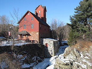
The Manchaug Village Historic District is a historic district encompassing the 19th century industrial village center of Manchaug in Sutton, Massachusetts. Developed in the 1820s around textile mills on the Mumford River, it was the largest industrial area in Sutton, with at least three mill complexes in operation. The district is centered on the junction of Main Street with Manchaug, Putnam Hill, and Whitins Roads.


