Chance, Maryland

Last updated

Chance, Maryland
CDP
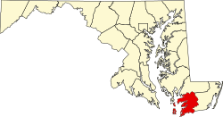
Somerset County Maryland Incorporated and Unincorporated areas Chance Highlighted.svg
Coordinates: 38°10′37″N75°56′21″W / 38.17694°N 75.93917°W / 38.17694; -75.93917
CountryFlag of the United States.svg United States
State Flag of Maryland.svg  Maryland
County Flag of Somerset County, Maryland.svg Somerset
Area
[1]
  Total2.58 sq mi (6.69 km2)
  Land1.67 sq mi (4.32 km2)
  Water0.91 sq mi (2.37 km2)
Elevation
3 ft (1 m)
Population
 (2020)
  Total330
  Density197.60/sq mi (76.31/km2)
Time zone UTC−5 (Eastern (EST))
  Summer (DST) UTC−4 (EDT)
ZIP code
21821
Area code 410
FIPS code 24-15075
GNIS feature ID0595203

Chance is a census-designated place (CDP) in Somerset County, Maryland, United States. The population was 377 at the 2000 census. It is included in the Salisbury, Maryland-Delaware Metropolitan Statistical Area.

Contents

History

The community took its name from the estate of the same name of an early settler. [2]

The Ida May and Rock Creek Methodist Episcopal Church are listed on the National Register of Historic Places. [3]

Geography

Chance is located at 38°10′37″N75°56′21″W / 38.17694°N 75.93917°W / 38.17694; -75.93917 (38.176818, 75.939272). [4]

According to the United States Census Bureau, the CDP has a total area of 2.6 square miles (6.7 km2), of which 1.7 square miles (4.4 km2) is land and 0.8 square miles (2.1 km2) (32.68%) is water.

Demographics

Historical population
CensusPop.Note
2020 330
U.S. Decennial Census [5]

As of the census [6] of 2000, there were 377 people, 161 households, and 113 families residing in the CDP. The population density was 218.1 inhabitants per square mile (84.2/km2). There were 254 housing units at an average density of 147.0 per square mile (56.8/km2). The racial makeup of the CDP was 75.60% White, 23.61% African American, 0.27% from other races, and 0.53% from two or more races. Hispanic or Latino of any race were 0.53% of the population.

There were 161 households, out of which 17.4% had children under the age of 18 living with them, 54.0% were married couples living together, 12.4% had a female householder with no husband present, and 29.2% were non-families. 23.6% of all households were made up of individuals, and 10.6% had someone living alone who was 65 years of age or older. The average household size was 2.34 and the average family size was 2.74.

In the CDP, the population was spread out, with 18.8% under the age of 18, 5.0% from 18 to 24, 24.1% from 25 to 44, 29.7% from 45 to 64, and 22.3% who were 65 years of age or older. The median age was 47 years. For every 100 females, there were 93.3 males. For every 100 females age 18 and over, there were 96.2 males.

The median income for a household in the CDP was $34,531, and the median income for a family was $37,969. Males had a median income of $25,469 versus $21,875 for females. The per capita income for the CDP was $15,706. About 16.8% of families and 23.2% of the population were below the poverty line, including 51.9% of those under age 18 and 14.3% of those age 65 or over.

Notable person

Related Research Articles

<span class="mw-page-title-main">Edgemoor, Delaware</span> CDP in Delaware, United States

Edgemoor is a census-designated place in New Castle County, Delaware, United States. The population was 5,677 at the 2010 census.

<span class="mw-page-title-main">Country Club, Florida</span> Census-designated place in Florida

Country Club is a suburban census-designated place located in northwest Miami-Dade County, Florida, United States. It is located in the Miami metropolitan area of South Florida. The CDP is named after the Country Club of Miami, which was established in 1961 in what was then an unpopulated and undeveloped section of the county. The population was 49,967 at the 2020 census, up from 3,408 in 1990.

<span class="mw-page-title-main">Oak Park, Indiana</span> CDP in Indiana, United States

Oak Park is a census-designated place (CDP) in Clark County, Indiana, United States. The population was 5,379 at the 2000 census.

<span class="mw-page-title-main">Grasonville, Maryland</span> CDP in Maryland, United States

Grasonville is a census-designated place (CDP) in Queen Anne's County, Maryland, United States. The population was 2,193 at the 2000 census.

<span class="mw-page-title-main">Dames Quarter, Maryland</span> CDP in Maryland, United States

Dames Quarter is a census-designated place (CDP) in Somerset County, Maryland, United States. The population was 188 at the 2000 census. It is included in the Salisbury, Maryland-Delaware Metropolitan Statistical Area.

<span class="mw-page-title-main">Fairmount, Maryland</span> CDP in Maryland, United States

Fairmount is a census-designated place (CDP) in Somerset County, Maryland, United States. The population was 537 at the 2000 census. It is included in the Salisbury, Maryland-Delaware Metropolitan Statistical Area.

<span class="mw-page-title-main">Frenchtown-Rumbly, Maryland</span> CDP in Maryland, United States

Frenchtown-Rumbly is a census-designated place in Somerset County, Maryland, United States. The population was 96 at the 2000 census. It is included in the Salisbury, Maryland-Delaware Metropolitan Statistical Area.

<span class="mw-page-title-main">Mount Vernon, Maryland</span> CDP in Maryland, United States

Mount Vernon is a census-designated place (CDP) in Somerset County, Maryland, United States. The population was 761 at the 2000 census. It is included in the Salisbury, Maryland-Delaware Metropolitan Statistical Area.

<span class="mw-page-title-main">West Pocomoke, Maryland</span> CDP in Maryland, United States

West Pocomoke is a census-designated place (CDP) in Somerset County, Maryland, United States. The population was 498 at the 2000 census. It is included in the Salisbury, Maryland-Delaware Metropolitan Statistical Area.

<span class="mw-page-title-main">North Woodbridge, California</span> Former census-designated place in California, United States

North Woodbridge was a former census-designated place (CDP) in San Joaquin County, California, United States. The population was 1,320 at the 2000 census. For the 2010 census, the CDP's of South Woodbridge and North Woodbridge were merged into Woodbridge.

<span class="mw-page-title-main">Pleasant Run, Ohio</span> Census-designated place in Ohio, United States

Pleasant Run is a census-designated place (CDP) in Colerain Township, Hamilton County, Ohio, United States. The population was 4,861 at the 2020 census.

<span class="mw-page-title-main">Kenilworth, Pennsylvania</span> Census-designated place in Pennsylvania, United States

Kenilworth is a census-designated place (CDP) in North Coventry Township, Chester County, Pennsylvania, United States. The population was 2,148 at the 2020 census.

Black Lick is a census-designated place (CDP) in Burrell Township, Indiana County, Pennsylvania, United States. The population was 1,462 at the 2010 census.

Ancient Oaks is a census-designated place (CDP) in Lower Macungie Township in Lehigh County, Pennsylvania, United States. It is named after the housing subdivision named Ancient Oaks, located off PA Route 100 just north of Macungie. The population of Ancient Oaks was 6,995 at the 2020 census.

Arlington Heights is a census-designated place (CDP) in Monroe County, Pennsylvania, United States. The population was 6,331 at the 2020 census. One notable location in Arlington Heights is the Stroud Mall.

<span class="mw-page-title-main">Brodheadsville, Pennsylvania</span> Census-designated place in Pennsylvania, United States

Brodheadsville is a census-designated place (CDP) in Monroe County, Pennsylvania, United States. The population was 1,700 at the 2020 census. The community is served by Pleasant Valley School District.

<span class="mw-page-title-main">Blessing, Texas</span> CDP in Texas, United States

Blessing is a census-designated place (CDP) in Matagorda County, Texas, United States. The population was 856 at the 2020 census.

<span class="mw-page-title-main">Huntington, Virginia</span> Census-designated place in Virginia, United States

Huntington is a census-designated place (CDP) in Fairfax County, Virginia, United States. The population was 11,267 at the 2010 census. It is located next to the southern border of the city of Alexandria and is part of the Washington metropolitan area. Its main component is the namesake Huntington subdivision, a late-1940s neighborhood of mainly duplex homes.

<span class="mw-page-title-main">Lakeside, Virginia</span> Census-designated area in Virginia

Lakeside is a census-designated place (CDP) in Henrico County, Virginia, United States. It is an inner suburb of Richmond, Virginia. The population was 12,203 at the 2020 census.

<span class="mw-page-title-main">Wild Rose, Wisconsin</span> Village in Wisconsin, United States

Wild Rose is a village in Waushara County, Wisconsin, United States. The population was 725 at the 2010 census.

References

  1. "2020 U.S. Gazetteer Files". United States Census Bureau. Retrieved April 26, 2022.
  2. Moyer, Armond; Moyer, Winifred (1958). The origins of unusual place-names. Keystone Pub. Associates. p. 21.
  3. "National Register Information System". National Register of Historic Places . National Park Service. July 9, 2010.
  4. "US Gazetteer files: 2010, 2000, and 1990". United States Census Bureau. February 12, 2011. Retrieved April 23, 2011.
  5. "Census of Population and Housing". Census.gov. Retrieved June 4, 2016.
  6. "U.S. Census website". United States Census Bureau . Retrieved January 31, 2008.