The South Central Falls Historic District is a historic district in Central Falls, Rhode Island. It is a predominantly residential area, densely populated, which was developed most heavily in the late 19th century. It is bounded roughly by Broad Street to the east, the Pawtucket city line to the south, Dexter Street to the west, and Rand Street and Jenks Park to the north. It has 377 contributing buildings, most of which were built before 1920. The district was added to the National Register of Historic Places in 1991.

The East Cambridge Historic District encompasses the historic center of East Cambridge, Massachusetts. It includes the major buildings that were built to house county services for Middlesex County beginning in the 1810s, and a cluster of largely vernacular Greek Revival worker housing located west of the county complex on Otis, Thorndike, Spring, and Sciarappa Streets. The district was listed on the National Register of Historic Places in 1983.

The Prospect Hill Historic District encompasses a large residential area in the Willimantic section of Windham, Connecticut. Located north of the Main Street commercial district, it was developed between about 1865 and 1930, and is one of the state's largest historic districts, with more than 800 contributing buildings. It is roughly bounded by Valley, Jackson, Bolivia, Washburn, Windham, and High Streets, and contains one of the state's largest single concentrations of Victorian-era residential architecture. It was listed on the National Register of Historic Places in 2003.

The Lower Highlands Historic District encompasses one of the oldest residential areas of Fall River, Massachusetts. The district is roughly bounded by Cherry, Main, Winter, and Bank Streets, and is located just east of the Downtown Fall River Historic District and directly south of the Highlands Historic District. This area was settled by 1810, has architecture tracing the city's growth as a major industrial center. The historic district was added to the National Register of Historic Places in 1984.

St. Mary's Roman Catholic Church Complex is a historic multi-building church complex at 133 School Street in Waltham, Massachusetts. Established as a parish in 1835, it is the city's oldest Roman Catholic establishment. Its 1858 Romanesque Revival church and 1872 Second Empire rectory are particularly fine architectural examples of their styles. The complex was listed on the National Register of Historic Places in 1989.

The Springfield Street Historic District is a predominantly residential historic district south of the downtown area of Chicopee, Massachusetts. It encompasses a significant number of Queen Anne style houses built in the second half of the 19th century by wealthy residents of Chicopee, as well as housing for skilled workers at the nearby textile mills. It is centered where Springfield Street and Fairview Avenue meet. The district was listed on the National Register of Historic Places in 1991.

The American Waltham Watch Company Historic District encompasses the former factory of the Waltham Watch Company, the leading American watch manufacturer of the 19th century and the city's largest employer. Located on Crescent Street and the banks of the Charles River, the surviving elements of its manufacturing facility date from the 1870s to the 1910s, and include particularly fine industrial Romanesque architecture. The buildings have been converted to a variety of commercial, industrial and residential uses since they ceased being used for watchmaking in the 1950s. The complex was listed on the National Register of Historic Places in 1989.

Boston Manufacturing Company Housing are historic residential housing blocks at 380-410 and 153-165 River Street in Waltham, Massachusetts. The housing was for the Boston Manufacturing Company (BMC), the earliest modern manufacturing facility in the United States. The housing was built in the nineteenth century and the two blocks of buildings were separately added to the National Register of Historic Places in 1989.

The Charles Baker House is a historic house at 107 Adams Street in Waltham, Massachusetts. Built about 1880, it is one of the city's best examples of Stick style architecture, and a good example of worker housing built for employees of the Waltham Watch Company. It was listed on the National Register of Historic Places in 1989.
The James Swasey House was a historic house at 30 Common Street in Waltham, Massachusetts. Built c. 1846, the 2-1/2 story wood frame house was a well-preserved example of vernacular Greek Revival architecture, of a sort that were typically built at the time as housing for local mill workers. James Swasey, the carpenter who built the house, and his wife occupied the house into the 20th century.

The North Lexington Street Historic District is a residential historic district at 508–536 North Lexington Street in Waltham, Massachusetts. It consists of a cluster of four houses and their associated outbuildings, built around the turn of the 20th century, and unusual for its state of cohesion and preservation given the busy nature of Lexington Street. Three houses are Colonial Revival in styling, and 528 Lexington is an 1873 Second Empire house. The house at 508 Lexington was built in 1865 and extensively restyled in 1905; it retains some Italianate styling. Particularly rare in Waltham is the converted barn at 526 Lexington Street. This cluster of buildings was traditionally associated with the Piety Corner area, but is now separated from it by a significant number of more modern buildings.

The Moody Street Historic District is a historic commercial district at Moody and Crescent Streets in Waltham, Massachusetts. It consists of eight commercial properties facing Moody Street as it runs south from the Charles River toward Newton. The area was developed between about 1880 and 1950, and is a reminder of the city's economic prosperity in that time. The district was listed on the National Register of Historic Places in 1990.

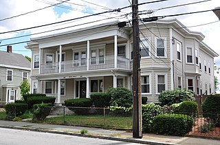
The Lawton Place Historic District is a historic district on Lawton Place between Amory Road and Jackson Street in Waltham, Massachusetts. The district preserves some of the nation's oldest textile mill worker housing. The duplex houses located on the south side of Lawton Place were built c. 1815-17 by the Boston Manufacturing Company (BMC), the first mill to process textiles entirely under one roof. They were originally located at what is now the Waltham Common, and were moved to Lawton Place in 1889. On the north side stands a rowhouse that was built in 1889; it is the last instance of a type of row housing that was once commonly built for mill workers. The district was listed on the National Register of Historic Places in 1989.

The Harrington Block is a historic commercial and retail building at 376–390 Moody Street in Waltham, Massachusetts. The three story brick building was built 1884-85 by Charles Harrington, a local real estate speculator who was also employed by the Boston Manufacturing Company. It is one of the city's few Queen Anne commercial building, and is the oldest commercial building on Moody Street to escape major alteration. The ground floor originally housed retail establishments, while the upper floors were residential.

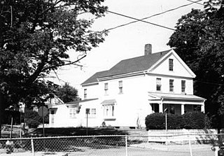
102 Staniford Street in the Auburndale section of Newton, Massachusetts, is a rare surviving element of Auburndale's agricultural past, including both a 19th-century house and barn. Built about 1869 and enlarged in 1915, it exhibits vernacular Italianate styling. It was listed on the National Register of Historic Places in 1986. As of 2014, it was still within the family of its original owner.

The Dwight Street Historic District is an irregularly shaped 135-acre (55 ha) historic district in New Haven, Connecticut. The district is located immediately west of the center of Downtown New Haven and is generally bounded by Elm Street on the north, Park Street on the east, North Frontage Road on the south, and Sherman Avenue on the west. It contains one of the city's highest concentrations of well-preserved 19th and early 20th-century residential architecture, much of which was developed for the working classes in the city's factories. It was listed on the National Register of Historic Places in 1983. The historic district includes most of the Dwight neighborhood and several blocks of the northeast corner of the West River neighborhood.

The Myrtle Baptist Church Neighborhood Historic District encompasses a historic center of the African-American community in West Newton, Massachusetts. The district includes all of Curve Street, where the Myrtle Baptist Church is located, as well as a few properties on adjacent Auburn and Prospect Streets. The district was listed on the National Register of Historic Places in 2008.

The Holden–Leonard Workers Housing Historic District encompasses a collection of mill-related tenement houses, plus a former mill store, in Bennington, Vermont. They are located on Benmont and Holden Avenues, near the former Holden–Leonard Mill Complex, Bennington's largest employer in the late 19th century. The district was listed on the National Register of Historic Places in 2011.

The Capen-Clark Historic District encompasses a residential neighborhood area in the North End of Hartford, Connecticut. Centered on Capen Street between Main and Enfield Streets, it contains a cross-section of post-Civil War Victorian vernacular housing styles, and shows in its development patterns the ebb and flow of the city's economy between about 1865 and 1910. The district was listed on the National Register of Historic Places in 1982.