Alaska is a U.S. state in the northwest extremity of North America, just across the Bering Strait from Asia. The Canadian province of British Columbia and territory of Yukon border the state to the east, its most extreme western part is Attu Island, and it has a maritime border with Russia to the west across the Bering Strait. To the north are the Chukchi and Beaufort seas—southern parts of the Arctic Ocean. The Pacific Ocean lies to the south and southwest. It is the largest U.S. state by area and the seventh largest subnational division in the world. In addition, it is the 3rd least populous and the most sparsely populated of the 50 United States; nevertheless, it is by far the most populous territory located mostly north of the 60th parallel in North America: its population—estimated at 738,432 by the United States Census Bureau in 2015— is more than quadruple the combined populations of Northern Canada and Greenland. Approximately half of Alaska's residents live within the Anchorage metropolitan area. Alaska's economy is dominated by the fishing, natural gas, and oil industries, resources which it has in abundance. Military bases and tourism are also a significant part of the economy.

Interior Alaska is the central region of Alaska's territory, roughly bounded by the Alaska Range to the south and the Brooks Range to the north. It is largely wilderness. Mountains include Denali in the Alaska Range, the Wrangell Mountains, and the Ray Mountains. The native people of the interior are Alaskan Athabaskans. The largest city in the interior is Fairbanks, Alaska's second-largest city, in the Tanana Valley. Other towns include North Pole, just southeast of Fairbanks, Eagle, Tok, Glennallen, Delta Junction, Nenana, Anderson, Healy and Cantwell. The interior region has an estimated population of 113,154.

North Pole is a small city in the Fairbanks North Star Borough, Alaska, United States. It is part of the Fairbanks, Alaska metropolitan statistical area. As of the 2016 United States Census, the city had a population of 2,232, up from 1,570 in 2000.

Nenana is a Home Rule City in the Yukon-Koyukuk Census Area of the Unorganized Borough in the Interior of the U.S. state of Alaska. Nenana developed as a Lower Tanana community at the confluence where the tributary Nenana River enters the Tanana. The population was 378 at the 2010 census, down from 402 in 2000.

Tanana is a city in the Yukon-Koyukuk Census Area in the U.S. state of Alaska. At the 2010 census the population was 246, down from 308 in 2000. It was formerly known as Clachotin, adopted by Canadian French.
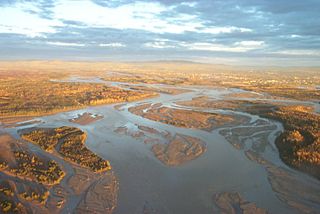
The Tanana River is a 584-mile (940 km) tributary of the Yukon River in the U.S. state of Alaska. According to linguist and anthropologist William Bright, the name is from the Koyukon (Athabaskan) tene no, tenene, literally "trail river".

The Nenana River is a tributary of the Tanana River, approximately 140 miles (230 km) long, in central Alaska in the United States. It drains an area on the north slope of the Alaska Range on the south edge of the Tanana Valley southwest of Fairbanks.

The Chena River is a 100-mile (160 km) tributary of the Tanana River in the Interior region of the U.S. state of Alaska. It flows generally west from the White Mountains to the Tanana River near the city of Fairbanks, which is built on both sides of the river. The Tanana empties into the 2,300-mile (3,700 km) long Yukon River.

The Elliott Highway is a highway in the U.S. state of Alaska that extends 152 miles (245 km) from Fox, about 10 miles (16 km) north of Fairbanks, to Manley Hot Springs. It was completed in 1959 and is part of Alaska Route 2.

The Yukon Quest 1,000-mile International Sled Dog Race, or simply Yukon Quest, is a sled dog race run every February between Fairbanks, Alaska, and Whitehorse, Yukon. Because of the harsh winter conditions, difficult trail, and the limited support that competitors are allowed, it is considered the "most difficult sled dog race in the world", or even the "toughest race in the world"—"even tougher, more selective and less attention-seeking than the Iditarod Trail Sled Dog Race." The originator envisioned it as "a race so rugged that only purists would participate."

Pioneer Park is a 44-acre (109-ha) city park in Fairbanks, Alaska, United States run by the Fairbanks North Star Borough Department of Parks and Recreation. The park commemorates early Alaskan history with multiple museums and historic displays on site. The park is located along the Chena River and is accessible from Peger and Airport Roads. A waterfront path connects the park to the Carlson Center, Growden Memorial Park and downtown Fairbanks. There is no admission fee to enter the park, though many of the museums and attractions do charge an entrance fee. Concessions are open from Memorial Day weekend through Labor Day, though the park is open year round and some events are held in the off-season. Free wi-fi is available.
Chena was a small town in interior Alaska near the confluence of the Chena and Tanana rivers whose heyday was in the first two decades of the 20th century, with a peak population of about 400 in 1907. By 1910 the population had fallen to 138.

Chatanika is a small unincorporated community located in the Fairbanks North Star Borough, Alaska, United States, north-northeast of the city of Fairbanks. The community runs along an approximately 20-mile (32 km) stretch of the Steese Highway, the majority of which sees the highway paralleled by the Chatanika River. The community consists of sparsely scattered residential subdivisions, several roadside businesses, a boat launch where the Steese Highway crosses the Chatanika River, relics of past gold mining operations in the area and the Poker Flat Research Range operated by the Geophysical Institute of the University of Alaska Fairbanks.
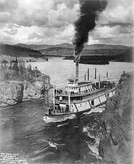
Steamboats on the Yukon River played a role in the development of Alaska and Yukon. Access to the interior of Alaska and Yukon was hindered by large mountains and distance, but the wide Yukon River provided a feasible route. The first steamers on the lower Yukon River were work boats for the Collins Overland Telegraph in 1866 or 1867, with a small steamer called Wilder. The mouth of the Yukon River is far to the west at St. Michael and a journey from Seattle or San Francisco covered some 4,000 miles (6,400 km).
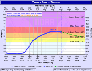
The 2008 Tanana Valley flood or the 2008 Fairbanks flood was a flood in late July and early August 2008 that affected several rivers in the central portion of the American state of Alaska. The city of Fairbanks, Alaska saw high water levels, while the towns of Nenana, Salcha, and Old Minto received heavy damage. The Salcha River and Tanana River reached their second-highest levels since record-keeping began, while the Chena River, which bisects Fairbanks, was kept below flood stage by the use of the Chena River Lakes Flood Control Project.
The Chatanika River is a 128-mile (206 km) tributary of the Tolovana River in the U.S. state of Alaska. The Chatanika River is a clear or lightly tannic stained rapid-runoff stream that has its headwaters in the mountains of the northeastern portion of the Alaska Range and flows westward through valleys between summits and uplands for about four-fifths of its length before it enters Minto Flats. Once in the flats—a marshy area in which multiple streams, rivers, and lakes are located— the Chatanika joins the Tolovana, which flows into the Tanana River and on to the Yukon River. The Chatanika is thus a portion of the Yukon River drainage basin.

The Fairbanks Gold Rush was a gold rush that took place in Fairbanks, Alaska in the early 1900s. Fairbanks was a city largely built on Gold Rush fervor at the beginning of the 20th century. Discovery and exploration continue to thrive in and around modern-day Fairbanks.
Elbridge Truman Barnette, Yukon riverboat captain, banker, and swindler, founded the city of Fairbanks, Alaska, and served as its first mayor.

The 2009 Alaska floods were a series of natural disasters taking place in the United States state of Alaska during April and May 2009. The floods are a result of heavier-than-typical winter snowfall and above-average spring temperatures that resulted in rapid melting of the winter snowfall. The resulting high water levels were aggravated in places by the development of ice dams that caused catastrophic flooding. The record-breaking flood that affected Eagle, Alaska in early May is the best example of an ice dam causing flooding beyond the norm.
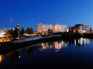
The history of Fairbanks, the second-largest city in Alaska, can be traced to the founding of a trading post by E.T. Barnette on the south bank of the Chena River on August 26, 1901. The area had seen human occupation since at least the last ice age, but a permanent settlement was not established at the site of Fairbanks until the 20th century.