The Loop is Chicago's central business district and one of the city's 77 municipally recognized community areas. Located at the center of downtown Chicago on the shores of Lake Michigan, it is the second-largest business district in North America after Midtown Manhattan. The headquarters and regional offices of several global and national businesses, retail establishments, restaurants, hotels, and theaters–as well as many of Chicago's most famous attractions–are located in the Loop. The neighborhood also hosts Chicago's City Hall, the seat of Cook County, offices of other levels of government, and several foreign consulates. The intersection of State Street and Madison Street in the Loop is the origin point for the address system on Chicago's street grid.

An underground city is a series of linked subterranean spaces that may provide a defensive refuge; a place for living, working or shopping; a transit system; mausolea; wine or storage cellars; cisterns or drainage channels; or several of these. Underground cities may be currently active modern creations or they may be historic including ancient sites, some of which may be entirely or partially open to the public.

Michigan Avenue is a north-south street in Chicago that runs at 100 east on the Chicago grid. The northern end of the street is at DuSable Lake Shore Drive on the shore of Lake Michigan in the Gold Coast Historic District. The street's southern terminus is at Sibley Boulevard in the southern suburb of Dolton, but like many other Chicago streets, it exists in several disjointed segments.
RÉSO, commonly referred to as the Underground City, is the name applied to a series of interconnected office towers, hotels, shopping centres, residential and commercial complexes, convention halls, universities and performing arts venues that form the heart of Montreal's central business district, colloquially referred to as Downtown Montreal. The name refers to the underground connections between the buildings that compose the network, in addition to the network's complete integration with the city's entirely underground rapid transit system, the Montreal Metro. Moreover, the first iteration of the Underground City was developed out of the open pit at the southern entrance to the Mount Royal Tunnel, where Place Ville Marie and Central Station stand today.

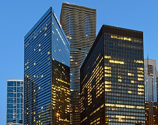
Chase Tower, located in the Chicago Loop area of Chicago, in the U.S. state of Illinois at 10 South Dearborn Street, is a 60-story skyscraper completed in 1969. At 850 feet tall, it is the fourteenth-tallest building in Chicago and the tallest building inside the Chicago 'L' Loop elevated tracks, and, as of May 2022, the 66th-tallest in the United States. JPMorgan Chase has its U.S. and Canada commercial and retail banking headquarters here. The building is also the headquarters of Exelon. The building and its plaza occupy the entire block bounded by Clark, Dearborn, Madison, and Monroe streets.

Path is a network of underground pedestrian tunnels, elevated walkways, and at-grade walkways connecting the office towers of Downtown Toronto, Ontario, Canada. It connects more than 70 buildings via 30 kilometres (19 mi) of tunnels, walkways, and shopping areas. According to Guinness World Records, Path is the largest underground shopping complex in the world, with 371,600 square metres (4,000,000 sq ft) of retail space which includes over 1,200 retail fronts (2016). As of 2016, over 200,000 residents and workers use the Path system daily with the number of private dwellings within walking distance at 30,115.

Wacker Drive is a major multilevel street in Chicago, Illinois, running along the south side of the main branch and the east side of the south branch of the Chicago River in the Loop. The vast majority of the street is double-decked; the upper level is intended for regular street-level traffic, and the lower level for service vehicles, deliveries, waste collection, utility access, and through traffic. It is sometimes cited as a precursor to the freeway, though when it was built, the idea was that pleasure vehicles would use the upper level. Since it follows the curving path of the Chicago River, Lower Wacker Drive is the only street in the city that adopts both North–South and East–West designations. In certain areas, there is a third level of Wacker Drive, often known as Lower Lower Wacker Drive or Sub-Lower Wacker Drive. This additional layer is primarily used for towing and impounding vehicles, utility infrastructure, and rail access in some areas. The street is named after early 20th-century Chicago businessman and city planner Charles H. Wacker.
Illinois Center is a mixed-use urban development in downtown Chicago, Illinois, USA, lying east of Michigan Avenue. It is notable in that the streets running through it have three levels. Elsewhere in Chicago, some streets have two levels, with the lower level for through traffic and service vehicles and the upper level for other local traffic. In Illinois Center, the lower level has been split, with a middle level for through traffic and a lower level for service vehicles.

Randolph Street is a street in Chicago running east–west through the Loop, carrying westbound traffic west from Michigan Avenue across the Chicago River on the Randolph Street Bridge, interchanging with the Kennedy Expressway (I-90/I-94), and continuing west. It serves as the northern boundary of Grant Park and the Chicago Landmark Historic Michigan Boulevard District. Several large theaters, as well as city and state government buildings are on and adjacent to Randolph. Metra's Millennium Station is located under Randolph Street.

Lakeshore East is a master-planned mixed use urban development being built by the Magellan Development Group in the Loop community area of Chicago in Cook County, Illinois, United States. It is located in the northeastern part of the Loop, which, along with Illinois Center, is called the New Eastside. The development is bordered by Wacker Drive to the north, Columbus Drive to the west, Lake Shore Drive to the east, and East Randolph Street to the south. Skidmore, Owings & Merrill created the master plan for the area. The development, which had been scheduled for completion in 2011, was set for completion in 2013 by 2008. Development continued with revised plans for more buildings in 2018 and continuing construction of the Vista Tower in 2019.

Millennium Station is a major commuter rail terminal in the Loop (downtown), Chicago. It is the northern terminus of the Metra Electric District to Chicago's southern suburbs, and the western terminus of the South Shore Line to Gary and South Bend, Indiana.
The Houston tunnel system is a network of subterranean, climate-controlled, pedestrian walkways that links 95 full city blocks 20 feet (6 m) below Houston's downtown streets. It is approximately six miles (9.7 km) long. There are similar systems in Chicago, Dallas, Oklahoma City, Montreal, and Toronto. Architectural historian Stephen Fox has stated that the idea for the tunnel system came when the Bank of the Southwest Building was "linked by tunnel to the 1010 Garage and the Mellie Esperson Building" in 1961.

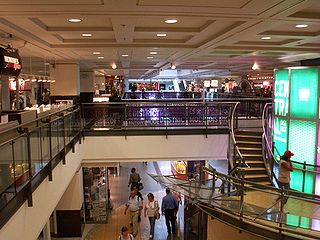
108 North State Street, also known as Block 37, is a development located in the Loop community area of downtown Chicago, Illinois. It is located on the square block bounded clockwise from the North by West Randolph Street, North State Street, West Washington Street and North Dearborn Street that is known as "Block 37", which was its designated number as one of the original 58 blocks of the city. Above-ground redevelopment is complete, but work stopped on an underground station, when the station was only partially complete.

The Blue Cross Blue Shield Tower (BCBS) is on the north end of Millennium Park along E. Randolph Street at the NE corner of Randolph and Columbus Drive, in Chicago, Illinois, United States. It is home to the headquarters of Health Care Service Corporation.

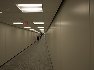
Lake is an "L" station on the CTA's Red Line in the Chicago Loop that is part of the State Street subway. Lake is a transfer station between the Red Line and the Brown, Green, Orange, Pink, and Purple Lines at the State/Lake station and the Blue Line at Washington via the Chicago Pedway. In 2019, Lake had an average of 19,364 weekday passenger entries, making it the busiest 'L' station.

Washington is an 'L' station on the CTA's Blue Line. It is situated between the Clark/Lake and Jackson stations in the Milwaukee-Dearborn subway and is near the Richard J. Daley Center.

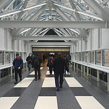
The Hyatt Regency Chicago is a 365-foot-tall (111 m) Hyatt hotel on East Wacker Drive in Chicago, Illinois. The hotel operates over 2,019 guest rooms in two different towers which were constructed in 1974 and 1980. The towers are connected by both an above-ground skyway and an underground concourse. This underground concourse is considered to be part of the Chicago Pedway. The hotel has a multi-level conference center which includes a 25,000-square-foot (2,300 m2) ballroom, and 85,000 square feet (7,900 m2) of meeting space. The conference center has been home to such events as the 40th, 49th, 58th, 70th and 80th World Science Fiction Conventions in 1982, 1991, 2000, 2012, and 2022 respectively.

The Exelon Pavilions are four buildings that generate electricity from solar energy and provide access to underground parking in Millennium Park in the Loop community area of Chicago in Cook County, Illinois, United States. The Northeast Exelon Pavilion and Northwest Exelon Pavilion are located on the northern edge of the park along Randolph Street, and flank the Harris Theater. The Southeast Exelon Pavilion and Southwest Exelon Pavilion are located on the southern edge of the park along Monroe Street, and flank the Lurie Garden. Together the pavilions generate 19,840 kilowatt-hours (71,400 MJ) of electricity annually, worth about $2,350 per year.

The Dallas Pedestrian Network or Dallas Pedway is a system of grade-separated walkways covering thirty-six city blocks of Downtown Dallas, Texas, United States. The system connects buildings, garages and parks through tunnels and above-ground skybridges. The network contains an underground city of shops, restaurants and offices during weekday business hours.