Chiquimula Department

Last updated
Chiquimula Department
Departmento de Chiquimula
Chiquimula.png
Collage of Chiquimula
Flag Of Chiquimula Department.jpg
Coat of Arms - Chiquimula Department, GT.gif
Chiquimula department and its neighbors.svg
Coordinates: 14°47′58″N89°32′37″W / 14.79944°N 89.54361°W / 14.79944; -89.54361
Country Flag of Guatemala.svg  Guatemala
Capital Chiquimula
Municipalities 11 [1]
Government
  Type Departmental
Area
   Department of Guatemala 2,376 km2 (917 sq mi)
Elevation
424 m (1,391 ft)
Population
 (2018) [2]
   Department of Guatemala 415,063
  Density170/km2 (450/sq mi)
   Urban
155,171
  Ethnicities
Chorti Ladino
  Languages
Chorti Spanish [3]
Time zone UTC-6
ISO 3166 code GT-CQ

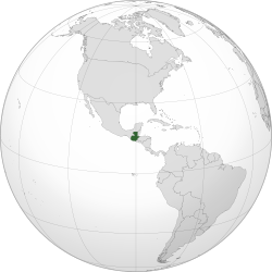
Chiquimula is one of the 22 departments of Guatemala, in Central America. [1] The departmental capital is also called Chiquimula. [3] The department was established by decree in 1871, and forms a part of the southeastern region of Guatemala. Physically, it is mountainous, with a climate that varies between tropical and temperate, depending on the location.

Contents

History

At the time of Spanish contact, Chiquimula was part of the indigenous kingdom of Chiquimulha, or Payaqui, governed from its capital at Copanti (now Copan, in Honduras). This kingdom also included portions of Honduras and El Salvador. [4] The name Chiquimula is derived from the Nahuatl chiquimoltlān, from chiquimolin meaning "finches" with the locative suffix -tlān, to mean "place of many finches". [5]

Chiquimula de la Sierra ("Chiquimula in the Highlands"), occupying the area of the modern department, was inhabited by Ch'orti' Maya at the time of the conquest. [6] The first Spanish reconnaissance of this region took place in 1524 by an expedition that included Hernando de Chávez, Juan Durán, Bartolomé Becerra and Cristóbal Salvatierra, amongst others. [7] In 1526 three Spanish captains, Juan Pérez Dardón, Sancho de Barahona and Bartolomé Becerra, invaded Chiquimula on the orders of Pedro de Alvarado. The indigenous population soon rebelled against excessive Spanish demands, but the rebellion was quickly put down in April 1530. [8] However, the region was not considered fully conquered until a campaign by Jorge de Bocanegra in 1531–1532 that also took in parts of Jalapa. [7] The afflictions of Old World diseases, war and overwork in the mines and encomiendas took a heavy toll on the inhabitants of eastern Guatemala, to the extent that indigenous population levels never recovered to their pre-conquest levels. [9]

The modern department was created by executive decree on 10 November 1871. The decree reduced the area covered by the administrative division of Chiquimula by removing that portion that now forms the modern department of Zacapa and part of the department of Izabal. [3]

Geography

Chiquimula is located in the southeastern region of Guatemala. It is bordered by the department of Zacapa to the north and the departments of Jalapa and Zacapa to the west. To the south, Chiqimula is bordered by the department of Jutiapa and the republic of El Salvador. To the east, the department is bordered by the republic of Honduras. [10]

The departmental capital is the city of Chiquimula, which is 170 kilometres (110 mi) from Guatemala City. [11]

Mountains cross the department from north to south, crossing from the border with Jalapa and joining the Sierra del Merendón range, which extends into neighbouring Honduras and El Salvador. Chiquimula possesses two drainage basins, one flowing towards the Atlantic Ocean, the other towards the Pacific Ocean. The principal river in the department is the Río Grande, or Camotán River, which flows in from Honduras, before becoming the Jocotán River, and flowing into the Motagua River to eventually drain into the Caribbean Sea. In the south of the department, the most important rivers are the Anguiatú and the Ostúa. [12]

The department has numerous mineral deposits, and silver has been mined there since the Spanish colonial period. [12]

Climate

Chiquimula is divided into two climatic zones; the municipalities of Concepción Las Minas, Esquipulas, Ipala, Olopa and Quetzaltepeque are temperate, while Camotán, Chiquimula, Jocotán, San Jacinto, San José La Arada and San Juan Ermita are tropical. [13] In the temperate areas, the average temperature is 27–28 °C (81–82 °F); in the tropical areas it reaches 36–38 °C (97–100 °F). Climate change has notably affected the department, with maximum temperatures reaching 42 °C (108 °F), and a decrease in rainfall contributing to scarcity of foodstuffs. [14] The lowest recorded temperature between 2009 and 2013 was 7.6 °C (45.7 °F) in 2010; during the same period, relative humidity varied between 74.5% and 76.6%. [15] Average annual precipitation is 1,036 millimetres (40.8 in). [14]

Population

At the 2018 census, the population of Chiquimula was 415,063. [2] In 2002, 83.33% of the population was non-indigenous and 16.67% was indigenous. [16] The majority of the indigenous population are Ch'orti' Maya, [17] with a very small number of Xinka and Garifuna. [18] In 2006, 59.5% of the population of the department was living in poverty, with 27.7% of the population living in extreme poverty (included within the former percentage). [16] Poverty levels tend to be higher in the northern portions of the department, and lower in the south. [19] In 2002, the department of Chiquimula contained 2.7% of the national population, [20] with a population density of 127 per square kilometre (329 per square mile), ranking it 10th of 22 departments for population density. [21] In 2013, 25.5% of the population were recorded as illiterate, demonstrating a year-on-year reduction in illiteracy rates over the previous five years. [22]

CensusPopulation [23]
1981168,863
1994230,767
2002302,485

In 2002, 26% of the population of the department lived in urban areas, and 74% in rural areas. [24] There were an average of 5.1 people per household; averaging 4.5 people per household in urban areas and rising to an average of 5.3 people per household in rural areas. [25]

Total population (2002)Aged 0–6Aged 7–14Aged 15–17Aged 18–59Aged 60–64Aged 65+ [23]
302,48563,81465,29721,020130,8416,55814,995
100%21.1%21.6%6.9%43.3%2.2%4.9%

Ethnicity and language

Breakdown of population by ethnicity for the whole departmental population, and first language in those aged three and above, as recorded in the 2002 census. [18]

CategoryGroupPopulation (2002)Ladino (Spanish)MayaXinkaGarifunaOther
EthnicityWhole population302,485255,92145,5587620910
Ethnicity%100%84.6%15.1%0.0%0.0%0.3%
First languageAged 3+275,222263,48611,5483139118
First language%91% of pop.95.7%4.2%0.0%0.0%0.0%

Mortality

In 2013, 2095 deaths were registered in the department, demonstrating a 1% drop on the previous year, and 2.9% of the national total: [26]

Mortality in 2013 [26]
Cause%
Pneumonia 19.7%
Myocardial infarction 18.9%
Gunshot wound 16.4%
Heart failure 10.7%
Diabetes mellitus 8.4%
Unspecified6.7%
Stroke 6.1%
Stomach cancer 5.3%
Knife wound4.1%
Diarrhoea 3.7%

Governance

The central park and Catholic church of Jocotan Iglesia de Jocotan.jpg
The central park and Catholic church of Jocotán

As with all Guatemalan departments, the regional government is headed by a governor appointed directly by the president of Guatemala. [27]

Municipalities

Since its establishment as a department in the late 19th century, Chiquimula has been divided into eleven municipalities. [3]

MunicipalityPopulation in 2002 [16] Indigenous % [16] Non-indigenous % [16] Extent [11]
Camotán 48,44083.16%16.84%231 square kilometres (89 sq mi)
Chiquimula 91,9512.63%97.37%353 square kilometres (136 sq mi)
Concepción Las Minas 12,8531.53%98.47%215 square kilometres (83 sq mi)
Esquipulas 53,2011.65%98.35%502 square kilometres (194 sq mi)
Ipala 19,8510.85%99.15%231 square kilometres (89 sq mi)
Jocotán 53,96081.25%18.75%252 square kilometres (97 sq mi)
Olopa 22,99334.08%65.92%112 square kilometres (43 sq mi)
Quezaltepeque 26,3821.57%98.43%245 square kilometres (95 sq mi)
San Jacinto 12,0052.20%97.80%71 square kilometres (27 sq mi)
San José La Arada 8,0812.70%97.30%116 square kilometres (45 sq mi)
San Juan Ermita 13,1088.92%91.08%90 square kilometres (35 sq mi)

Economy

Principle products of the department of Chiquimula are cattle, rice, maize, beans, potato, coffee, cacao, peanuts and tropical fruits, ceramics, rope, leather and palm products. [3] Palm handicrafts include the manufacture of a variety of baskets for different purposes. [28]

Tourism

The Black Christ of Esquipulas is the focus of international pilgrimage Cristo negro de Esquipulas.jpg
The Black Christ of Esquipulas is the focus of international pilgrimage

Esquipulas is one of the most important centres for religious pilgrimage in Central America, focused upon the Black Christ of Esquipulas contained in the basilica church, [29] which has been venerated due to miracles attributed to the image. [30]


In the news 2021

In January 2021, a caravan of between 7,000- 9,000 migrants from Honduras, who had departed from San Pedro Sula was heading towards the United States and broke through police lines at Vado Hondo, a village near the city of Chiquimula. [31]

Notes

  1. 1 2 INE 2002, p. 12.
  2. 1 2 Citypopulation.de Population of departments in Guatemala
  3. 1 2 3 4 5 Hernández and González 2004.
  4. SEGEPLAN 2001, p. 12.
  5. Carpio Rezzio 1999, p. 4.
  6. Castro Ramos 2003, p. 40
  7. 1 2 Dary Fuentes 2008, p. 59.
  8. Putzeys and Flores 2007, p. 1475.
  9. Dary Fuentes 2008, p. 60.
  10. SEGEPLAN 2001, p. 10.
  11. 1 2 SEGEPLAN 2001, p. 11.
  12. 1 2 Carpio Rezzio 1999, p. 5.
  13. SEGEPLAN 2001, pp. 18–19.
  14. 1 2 SEGEPLAN 2001, p. 19.
  15. INE 2014, p. 53.
  16. 1 2 3 4 5 SEGEPLAN 2001, p. 14.
  17. SEGEPLAN 2001, p. 13.
  18. 1 2 INE 2002, p. 75.
  19. INE 2014, p. 25.
  20. INE 2002, p. 15.
  21. INE 2002, p. 16.
  22. Ine 2014, p. 23.
  23. 1 2 INE 2002, p.14.
  24. INE 2002, p. 18.
  25. INE 2002, p. 57.
  26. 1 2 INE 2014, p. 18.
  27. Aguirre Barrera 2009, p. 28.
  28. Franco Sandoval 2003, p. 80.
  29. SEGEPLAN 2001, p. 18.
  30. Franco Sandoval 2003, p. 73.
  31. Welle (www.dw.com) (2021-01-17). "Guatemala cracks down on US-bound migrant caravan | DW | 17.01.2021". Deutsche Welle. Retrieved 2021-01-19.

Related Research Articles

<span class="mw-page-title-main">Esquipulas</span> Municipality and town in Chiquimula Department, Guatemala

Esquipulas, officially Municipality of Esquipulas, whose original name was Yzquipulas, is a town, with a population of 18,667, and a municipality located in the department of Chiquimula, in eastern Guatemala. Esquipulas' main attraction is the beautiful Black Christ located in the Basilica of Esquipulas, making the town an important place of Catholic pilgrimage for Central America. It is also one of the most important towns of the country and one that has had the most economic and cultural growth.

<span class="mw-page-title-main">Santa Bárbara Department, Honduras</span> Department in Honduras

Santa Bárbara is one of the 18 departments (departamentos) into which Honduras is divided. The departmental capital is Santa Bárbara.

<span class="mw-page-title-main">Yoro Department</span> Department in Honduras

Yoro is one of the 18 departments into which Honduras is divided. The department contains rich agricultural lands, concentrated mainly on the valley of the Aguan River and the Sula Valley, on opposite ends. The departmental capital is Yoro. The department covers a total surface area of 7,939 km² and, in 2005, had an estimated population of 503,886 people. It is famous for the Lluvia de Peces, a tradition by which fish fall from the sky during very heavy rains.

<span class="mw-page-title-main">Jutiapa Department</span> Department of Guatemala

Jutiapa Department is a department of Guatemala that borders along El Salvador and the Pacific Ocean. The capital is the city of Jutiapa. As of 2018, it has a population of 488,395. The department is divided into seventeen municipalities. Jutiapa is the country's southeasternmost department and officially the only department with no Mayan descendants native to the region. The main crops are sorghum, tobacco, onion and corn. The climate is dry. An important attraction is the cattle fair. It is at 405 m above sea level.

<span class="mw-page-title-main">El Progreso Department</span> Department of Guatemala

El Progreso is a department in Guatemala. The departmental capital is Guastatoya. The Spanish established themselves in the region by 1551, after the Spanish conquest of Guatemala. El Progreso was declared a department in 1908, but was dissolved in 1920 before being reestablished in 1934. Guastatoya was badly affected by the 1976 Guatemala earthquake.

<span class="mw-page-title-main">Totonicapán Department</span> Department of Guatemala

Totonicapán is one of the 22 departments of Guatemala. The capital is the city of Totonicapán.

<span class="mw-page-title-main">Zacapa Department</span> Department of Guatemala

Zacapa is one of the 22 departments of Guatemala. It lies in eastern Guatemala with its capital in the city of Zacapa, approximately 112 kilometers from Guatemala City.

<span class="mw-page-title-main">Doroteo Vasconcelos</span>

Doroteo Vasconcelos Vides y Ladrón de Guevara was President of El Salvador 7 February 1848 - 1 February 1850 and 4 February 1850 – 1 March 1851. Vasconcelos was close friend of Honduran general Francisco Morazán. He tried to invade Guatemala and defeat general Rafael Carrera on 2 February 1851 but he was defeated. After defeat, he retired from public life.

<span class="mw-page-title-main">Ocotepeque</span> Municipality in Honduras

Ocotepeque is a municipality in the Honduran department of Ocotepeque. The town of Nueva Ocotepeque is the municipal seat and the capital of the department.

Concepción Las Minas is a municipality in southern Chiquimula department of Guatemala in Central America. It has a population of 11,693 (2018) and cover an area of 222 km2.

Jocotán is a town and municipality in the Chiquimula department of Guatemala.

Olopa is a municipality in the Chiquimula department of Guatemala. The municipality comprises an area of 112 km2, distributed in 1 town (Olopa) and 29 villages, with a total population of 27,511.

<span class="mw-page-title-main">Mataquescuintla</span> Municipality in Jalapa, Guatemala

Mataquescuintla is a town and municipality in the Jalapa department of south-east Guatemala. It covers 262 square kilometres (101 sq mi).

The Chʼortiʼ people are one of the indigenous Maya peoples, who primarily reside in communities and towns of southeastern Guatemala, northwestern Honduras, and northern El Salvador. Their indigenous language, also known as Chʼortiʼ, is a survival of Classic Choltian, the language of the inscriptions in Copan. It is the first language of approximately 15,000 people, although the majority of present-day Chʼortiʼ speakers are bilingual in Spanish as well.

<span class="mw-page-title-main">Roman Catholic Archdiocese of Santiago de Guatemala</span> Roman Catholic archdiocese in Guatemala

The Archdiocese of Santiago de Guatemala is a Latin Church ecclesiastical territory or archdiocese of the Catholic Church in Guatemala. It is a primatial metropolitan see with six suffragan dioceses in its ecclesiastical province.

<span class="mw-page-title-main">Roman Catholic Diocese of Jalapa (Guatemala)</span> Roman Catholic diocese in Guatemala

The Diocese of Jalapa is a Latin Church ecclesiastical territory or diocese of the Catholic Church in southeastern Guatemala. It is a suffragan diocese in the ecclesiastical province of the metropolitan Archdiocese of Santiago de Guatemala.

<span class="mw-page-title-main">Roman Catholic Diocese of Zacapa y Santo Cristo de Esquipulas</span> Roman Catholic diocese in Guatemala

The Roman Catholic Diocese of Zacapa (y Santo Cristo de Esquipulas) is a Latin suffragan diocese in the ecclesiastical province of the Archdiocese of Guatemala.

<span class="mw-page-title-main">Intibucá, Intibucá</span> Municipality in Intibucá, Honduras

Intibucá is a city, with a population of 28,220, and a municipality in the department of Intibucá, Honduras. The urban area of Intibucá is an important transit and commercial site in the South-West region of Honduras. Located 1,850 meters above sea level, Intibucá has a cool and often foggy climate, hence the nickname "La ciudad del manto blanco". Potato production, celebrated by the annual Festival de la Papa, is the principal basis of the economy for the municipality.

San Jorge is a municipality in the Guatemalan department of Zacapa, located approximately 8 kilometres (5.0 mi) southwest of the departmental capital, also called Zacapa.

References