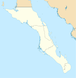
Baja California Sur, officially Estado Libre y Soberano de Baja California Sur, is the least populated state and the last state to be admitted to Mexico, in 1974. It is also the ninth-largest Mexican state in terms of area.

La Paz is the capital and largest city of the Mexican state of Baja California Sur, with a 2020 census population of 250,141 inhabitants, making it the most populous city in the state. La Paz City is located in La Paz Municipality—the fourth-largest municipality in Mexico, by area and populace, covering an area of 20,275 km2 (7,828 sq mi).
Baja California Sur is a state in Northwest Mexico divided into five municipalities. According to the 2020 Mexican census, Baja California Sur is the second least populous state with 798,447 inhabitants and the 11th largest by land area, spanning 73,909.4 square kilometres (28,536.6 sq mi).

Loreto is a city and municipal seat of Loreto Municipality, Baja California Sur, on the West Coast of Mexico. Located on the Gulf of California, the city had a population of 16,311 inhabitants in 2020. Loreto is a regional economic and cultural center, as well as a major tourist destination on the Baja California Peninsula.
Mulegé is a city in Mulegé Municipality, Baja California Sur, situated on the Gulf of California. Located on the Gulf of California, the population was 3,834 according to the Mexican census of 2020.

Federal Highway 1 is a free (libre) part of the federal highway corridors of Mexico, and the highway follows the length of the Baja California Peninsula from Tijuana, Baja California, in the north to Cabo San Lucas, Baja California Sur, in the south. The road connects with Via Rapida, which merges into the American Interstate 5 (I-5) at the San Ysidro Port of Entry, which crosses the international border south of San Ysidro, California.

Comondú is a municipality in the Mexican state of Baja California Sur. It had a population of 73,021 inhabitants in 2020. With a land area of 16,318.6 km2, it is the seventh-largest municipality in area in Mexico. The municipal seat is located in Ciudad Constitución.

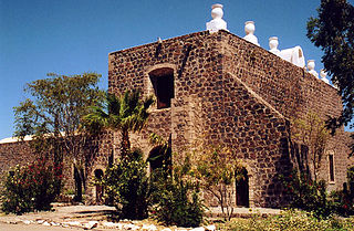
Loreto is a municipality in the Mexican state of Baja California Sur. It was created in 1992 from the partition of the neighboring Comondú Municipality. The municipal seat is in the town of Loreto, which was the former capital of Las Californias during Spanish colonial times.

The El Vizcaíno Biosphere Reserve, created in 1988, is located in Mulegé Municipality in northern Baja California Sur, at the center of the Baja California Peninsula between the Pacific Ocean and the Gulf of California. With an area of over 24,930 km2 (9,630 sq mi)), it is the largest wildlife refuge in Mexico and borders the northern edge of the Valle de los Cirios Protected Area of Flora and Fauna.
The Comondú Complex is an archaeological pattern dating from the late prehistoric period in northern Baja California Sur and southern Baja California. It is associated with the historic Cochimí people of the peninsula.

Calafia Airlines, legally Calafia Airlines S.A. de C.V. is a Mexican regional airline based in Cabo San Lucas, Baja California Sur, Mexico. It operates regular flights to the Baja California Peninsula, the Mexican Pacific coast and Northern Mexico, in addition to charter flights and tours. Its main hub is Cabo San Lucas Airport and has focus city operations in La Paz and Loreto. It operates a fleet consisting of Embraer regional jet aircraft. It is named after Calafia, the legendary warrior queen of the island of California.
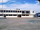
Ciudad Constitución National Airport (Spanish: Aeropuerto Nacional de Ciudad Constitución); officially Aeropuerto Nacional Capitán Jaime Emilio Real Cossio(Capitain Jaime Emilio Real Cossio National Airport) (IATA: CUA, ICAO: MMDA) is an airfield situated 6 kilometres (3.7 mi) east of Ciudad Constitución, Baja California Sur, Mexico. The airport primarily caters to regional flights and general aviation activities for Ciudad Constitución. Owned by the Municipality of Comondú Government, the airport has been operated by the regional airline Aereo Servicio Guerrero since 2007, providing commuter flights within the region. The airport is named after Jaime Emilio Real Cossio, a distinguished aviator pilot born in Villa Constitución.
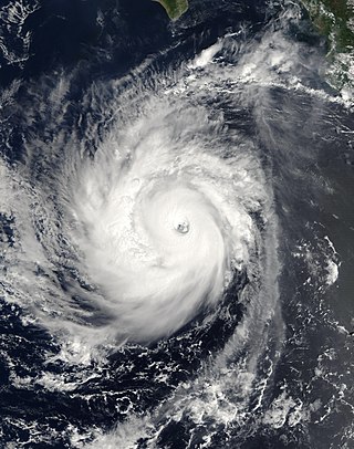
Hurricane Norbert is tied with Hurricane Jimena as the strongest tropical cyclone to strike the west coast of Baja California Sur in recorded history. The fifteenth named storm, seventh hurricane, and second major hurricane of the 2008 hurricane season, Norbert originated as a tropical depression from a tropical wave south of Acapulco on October 3. Strong wind shear initially prevented much development, but the cyclone encountered a more favorable environment as it moved westward. On October 5, the National Hurricane Center (NHC) upgraded the depression to Tropical Storm Norbert, and the system intensified further to attain hurricane intensity by October 6. After undergoing a period of rapid deepening, Norbert reached its peak intensity as a Category 4 on the Saffir–Simpson hurricane wind scale, with maximum sustained winds of 135 mph (217 km/h) and a minimum barometric pressure of 945 mbar. As the cyclone rounded the western periphery of a subtropical ridge over Mexico, it began an eyewall replacement cycle which led to steady weakening. Completing this cycle and briefly reintensifying into a major hurricane, a Category 3 or higher on the Saffir–Simpson hurricane wind scale, Norbert moved ashore Baja California Sur as a Category 2 hurricane late on October 11. After a second landfall at a weaker intensity the following day, the system quickly weakened over land and dissipated that afternoon.

Hurricane Jimena is tied with Hurricane Norbert as the strongest tropical cyclone to make landfall on western portion of the Baja California Peninsula. Jimena was the twelfth named storm, fifth hurricane, third major hurricane and overall second-strongest tropical cyclone of the 2009 Pacific hurricane season. Forming from a tropical wave late on August 28, 2009, off of Mexico's Pacific coast, the system rapidly intensified into a Category 2 hurricane on the next day. Two days after developing, Jimena strengthened into a Category 4 hurricane. After peaking close to Category 5 intensity on September 1, it encountered cold water and began to weaken. When the hurricane made landfall on the Baja California Peninsula on September 3, it was only a Category 2 hurricane. On the next day, the tropical cyclone entered the Gulf of California, though the storm weakened into a remnant low after looping back eastward towards Baja California. The storm's remnants drifted westward into the Pacific afterward, before dissipating on September 8.

Ciudad Insurgentes is a city in the Mexican state of Baja California Sur. It is the second-largest community in the municipality of Comondú and is located 250 kilometers north of La Paz, Baja California Sur, and 175 kilometers south of Loreto, Baja California Sur. Ciudad Insurgentes's population was 9,133 inhabitants in the 2020 census.

Hurricane Paul was a strong tropical cyclone that threatened the Baja California peninsula during October 2012. The sixteenth tropical cyclone, tenth hurricane, and fifth major hurricane of the season, Paul originated from a trough of low pressure west of the coastline of Mexico on October 13. While turning towards the north, the system quickly organized, reaching hurricane status in the morning of October 15. By that afternoon, Paul had reached its peak intensity as a Category 3 hurricane on the Saffir-Simpson hurricane wind scale (SSHWS) with maximum sustained winds of 120 mph (195 km/h), but began to weaken rapidly thereafter due to land interaction and strong wind shear. Late on October 17, Paul degenerated into a remnant low. The remnants of Paul later moved ashore along the central Baja California Peninsula, before dissipating on October 18.
The following television stations broadcast on digital channel 27 in Mexico:
Gil Cueva Tabardillo is a Mexican politician representing the National Action Party (PAN). He served in the XIII Legislature of the Congress of Baja California Sur from 2011 to 2015.
Rogelio Martínez Santillán was a Mexican educator, trade unionist and politician. He served in the XI Legislature of the Congress of Baja California Sur from 2005 to 2008 as a member of the Party of the Democratic Revolution (PRD).