
Northumberland is a county in Northern England, one of two counties in England which border with Scotland. Notable landmarks in the county include Alnwick Castle, Bamburgh Castle, Hadrian's Wall and Hexham Abbey.

Pity Me is a suburban village of Durham, England, located north of Framwellgate Moor and west of Newton Hall.

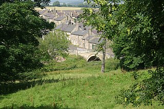
Morpeth is a historic market town in Northumberland, North East England, lying on the River Wansbeck. Nearby towns include Ashington and Bedlington. In the 2011 census, the population of Morpeth was given as 14,017, up from 13,833 in the 2001 census. The earliest evidence of settlement is believed to be from the Neolithic period, and some Roman artifacts have also been found. The first written mention of the town is from 1080, when the de Merlay family was granted the barony of Morpeth. The meaning of the town's name is uncertain, but it may refer to its position on the road to Scotland and a murder which occurred on that road. The de Merlay family built two castles in the town in the late 11th century and the 13th century. The town was granted its coat of arms in 1552. By the mid 1700s it had become one of the main markets in England, having been granted a market charter in 1200, but the opening of the railways in the 1800s led the market to decline. The town's history is celebrated in the annual Northumbrian Gathering.

The River Coquet runs through the county of Northumberland, England, discharging into the North Sea on the east coast at Amble. It rises in the Cheviot Hills on the border between England and Scotland, and follows a winding course across the landscape ("Coquetdale"). The upper reaches are bordered by the Otterburn Ranges military training ground, and are crossed by a number of bridges built in the 20th century. It passes a number of small villages and hamlets, and feeds one of the lakes created by extraction of gravel that form the Caistron Nature Reserve, before reaching the town of Rothbury, where it is crossed by a grade II listed bridge. Below the town is Thrum Mill, the restoration of which was featured on Channel 4 television.

Hexham is a constituency in Northumberland represented in the House of Commons of the UK Parliament since 2010 by Guy Opperman, a Conservative. As with all constituencies, the constituency elects one Member of Parliament (MP) by the first past the post system of election at least every five years.

Cambois is a village in south-east Northumberland, England. It is situated on the north side of the estuary of the River Blyth between Blyth and Ashington on the North Sea coast.
Thropton is a hamlet in Northumberland, England, located on the River Coquet, and its tributary Wreigh Burn. With a population of 458 it is situated 1.9 miles (3.1 km) west of the village of Rothbury connected by the B6431 near the junction of the Wreigh Burn and the River Coquet. In the hamlet is a stone bridge over the Wreigh Burn which was built in 1811. Thropton is on the edge of Northumberland National Park, and the surrounding area north and south of the hamlet consists of haughs, and also to the south on the opppisite side of the Coquet lies Simonside Hills, a hill range that has many crags dotted along it.

Bowden Housteads Woods are situated between Darnall and Handsworth, Sheffield, South Yorkshire, England. the woods are encircled by Sheffield Outer Ring Road, Sheffield Parkway and Handsworth Road. The woods are classified as ancient woodlands, having been in existence since the 17th century, the Car Brook flows through the wooded area. Spring brings a carpet of bluebells. The woods are a Local Nature Reserve.

The A1068 is a road in northern England that runs from Seaton Burn in North Tyneside to Alnwick in Northumberland. The section between Ellington and Alnmouth is signposted as part of the Northumberland Coastal Route.

Clifton is a village and civil parish in the English county of Bedfordshire. The original hundred of Clifton is named after it.
The NE postcode area, also known as the Newcastle upon Tyne postcode area, is a group of 61 postcode districts in north-east England covering 34 post towns. These cover most of Tyne and Wear and Northumberland, plus a very small part of northern County Durham.

Longframlington is a small village in Northumberland, England, located on the A697, 11 miles (18 km) north-west of Morpeth and 5 miles (8 km) south-east of Rothbury. Longframlington is a former pit village and on the site of the pit now stands Fram Park, a log cabin holiday park. The village was previously the site of the Longframlington Music Festival.

Ightenhill is a civil parish in the Borough of Burnley in Lancashire, England, with a population of 1,975.

County Hall is a municipal building in Morpeth, Northumberland, United Kingdom. It is the offices and meeting place of Northumberland County Council. The current building was completed in April 1981, after the county hall was moved from the old county hall in Newcastle. A statue of a Viking Warrior stands outside the building and was moved there from Doxford Hall.
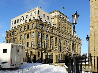
County Hall is a former municipal building, now a hotel, in Castle Garth, in Newcastle upon Tyne, England. The county hall, which was the meeting place of Northumberland County Council from 1910 to 1981, is a Grade II listed building.
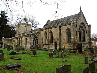
St Mary's, also known as St Mary the Virgin, is an ancient Grade I listed Church of England parish church located in Morpeth, Northumberland. The church is to the south of the River Wansbeck in Morpeth, which is an area known as High Church. The oldest remaining parts of the structure belong to the Transitional Early English style of the mid to late 12th century, but the church is mostly in the 14th century style. The church, which was the main Anglican place of worship in the area until the 1840s, has been restored several times after being destroyed by the Scandinavians, Scottish and Cromwellians in the 10th and later centuries.

Glororum is a hamlet in the civil parish of Stannington in Northumberland, England, about 0.6 miles (1 km) west of Clifton and the A1 road. The nearest railway station is Morpeth on the East Coast Main Line. An infrequent bus service operates between Morpeth and Stannington or St Mary's Park.
Hebron is a village and civil parish 2 miles (3.2 km) north of Morpeth, in the county of Northumberland, England. In 2011 the parish had a population of 422. The parish touches Longhirst, Meldon, Mitford, Morpeth, Netherwitton, Pegswood, Tritlington and West Chevington and Ulgham. Until April 2009 the parish was in Castle Morpeth district. The surname "Hebron" derives from Hebron.

Roddam is a village and civil parish about 24 miles from Morpeth, in the county of Northumberland, England. In 2001 the parish had a population of 77. The parish touches Bewick, Hedgeley, Ilderton, Ingram and Lilburn. It lies near the foot of the Cheviot Hills.

North Steads Wind Farm is an onshore electricity generating site west of Widdrington in Northumberland, England. The site was developed on old coal opencast workings and has nine turbines delivering over 18 megawatts of power per year.
