Collins Beach (Sauvie Island)

Last updated
Collins Beach
AUT5507-b.jpg
Collins Beach
USA Oregon relief location map.svg
Red pog.svg
Collins Beach
Coordinates: 45°47′35″N122°47′20″W / 45.793°N 122.789°W / 45.793; -122.789
LocationSauvie Island, Oregon, United States
Offshore water bodiesColumbia River
OperatorOregon Department of Fish and Wildlife
Dimensions
  Length1 mile

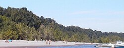
Collins Beach is a sandy beach on the Columbia River side of Sauvie Island in Oregon, United States, located north of Portland.

Part of it is a clothing-optional area. The beach is one mile (1.6 km) long and begins about 0.25 miles (400 m) after Reeder Road becomes gravel. Hours are 4:00 a.m. to 10:00 p.m. every day.

The beach has been popular for nude use since at least the 1970s. It is surrounded by a 12,000-acre (49 km2) fish and game reserve, except for a 10-acre (4.0 ha) parcel of privately owned land west of Reeder Road at the north boundary of Collins Beach. Nude beach users continue onto the non-nude North Unit Beach which is poorly delineated and ineffectively screened from view, which has led to a legal complaint by the property owners. [1]

Collins Beach is one of two official clothing-optional beaches in Oregon after Glass Bar Island's in Eugene, Oregon closed. The other is Rooster Rock State Park. It is administered by the Oregon Department of Fish and Wildlife in cooperation with the Columbia County Sheriff's Office. [2] [1]

Related Research Articles

<span class="mw-page-title-main">Sandy Hook</span> Peninsula in New Jersey

Sandy Hook is a barrier spit in Middletown Township, Monmouth County, New Jersey, United States. The barrier spit, approximately 6 miles (9.7 km) in length and varying from 0.1 to 1.0 mile wide, is located at the north end of the Jersey Shore. It encloses the southern entrance of Lower New York Bay south of New York City, protecting it from the open waters of the Atlantic Ocean to the east.

<span class="mw-page-title-main">Oregon Coast</span> Coastal region of the U.S. state of Oregon

The Oregon Coast is a coastal region of the U.S. state of Oregon. It is bordered by the Pacific Ocean to its west and the Oregon Coast Range to the east, and stretches approximately 362 miles (583 km) from the California state border in the south to the Columbia River in the north. The region is not a specific geological, environmental, or political entity, and includes the Columbia River Estuary.

<span class="mw-page-title-main">Sauvie Island</span> Island in the state of Oregon

Sauvie Island, in the U.S. state of Oregon, originally Wapato Island or Wappatoo Island, is the largest island along the Columbia River, at 26,000 acres (10,522 ha), and one of the largest river islands in the United States. It lies approximately ten miles northwest of downtown Portland, between the Columbia River to the east, the Multnomah Channel to the west, and the Willamette River to the south. A large portion of the island is designated as the Sauvie Island Wildlife Area. Sturgeon Lake, in the north central part of the island, is the most prominent water feature. The land area is 32.75 square miles (84.8 km2), or 20,959 acres (8,482 ha). Most of the island is in Multnomah County, but the northern third is in Columbia County. The Sauvie Island Bridge provides access across the Multnomah Channel from U.S. Route 30 and was completed in June 2008, replacing the first bridge to connect the island to the mainland which was opened on December 30, 1950.

<span class="mw-page-title-main">Forest Park (Portland, Oregon)</span> Public municipal park west of downtown Portland, Oregon

Forest Park is a public municipal park in the Tualatin Mountains west of downtown Portland, Oregon, United States. Stretching for more than 8 miles (13 km) on hillsides overlooking the Willamette River, it is one of the country's largest urban forest reserves. The park, a major component of a regional system of parks and trails, covers more than 5,100 acres (2,064 ha) of mostly second-growth forest with a few patches of old growth. About 70 miles (110 km) of recreational trails, including the Wildwood Trail segment of the city's 40-Mile Loop system, crisscross the park.

<span class="mw-page-title-main">Black's Beach</span> Nude beach near San Diego, California, United States

Black's Beach is a secluded section of beach beneath the bluffs of Torrey Pines on the Pacific Ocean in La Jolla, San Diego, California, United States. It is officially part of Torrey Pines State Beach. The northern portion of Black's Beach is owned and managed by the California Department of Parks and Recreation, while the southern portion of the beach, officially known as Torrey Pines City Beach, is jointly owned by the city of San Diego and the state park, but is managed by the city of San Diego. This distinction is important as Black's Beach is most known as a nude beach, a practice that is now prohibited in the southern portion managed by the city of San Diego.

<span class="mw-page-title-main">Rooster Rock State Park</span> State park in Oregon, United States

Rooster Rock State Park is a state park located east of Corbett, in the U.S. state of Oregon. One of the features of the park is Rooster Rock, a column of basalt forming a natural obelisk, which stands near the south side of the Columbia River Gorge, in the lee of Crown Point. The park is administered by the Oregon Parks and Recreation Department.

<span class="mw-page-title-main">Multnomah Channel</span> River in Oregon, United States

The Multnomah Channel is a 21.5-mile (34.6 km) distributary of the Willamette River. It diverges from the main stem a few miles upstream of the main stem's confluence with the Columbia River in Multnomah County in the U.S. state of Oregon. The channel flows northwest then north around Sauvie Island to meet the Columbia River near the city of St. Helens, in Columbia County.

<span class="mw-page-title-main">Grays Harbor</span>

Grays Harbor is an estuarine bay located 45 miles (72 km) north of the mouth of the Columbia River, on the southwest Pacific coast of Washington state, in the United States. It is a ria, which formed at the end of the last ice age, when sea levels flooded the Chehalis River. The bay is 17 miles (27 km) long and 12 miles (19 km) wide. The Chehalis River flows into its eastern end, where the city of Aberdeen stands at that river's mouth, on its north bank, with the somewhat smaller city of Hoquiam immediately to its northwest, along the bayshore. Besides the Chehalis, many lesser rivers and streams flow into Grays Harbor, such as Hoquiam River and Humptulips River. A pair of low peninsulas separate it from the Pacific Ocean, except for an opening about two miles (3 km) in width. The northern peninsula, which is largely covered by the community of Ocean Shores, ends in Point Brown. Facing that across the bay-mouth is Point Chehalis, at the end of the southern peninsula upon which stands the town of Westport.

<span class="mw-page-title-main">Johnson Creek (Willamette River tributary)</span> Creek in Oregon, USA

Johnson Creek is a 25-mile (40 km) tributary of the Willamette River in the Portland metropolitan area of the U.S. state of Oregon. Part of the drainage basin of the Columbia River, its catchment consists of 54 square miles (140 km2) of mostly urban land occupied by about 180,000 people as of 2012. Passing through the cities of Gresham, Portland, and Milwaukie, the creek flows generally west from the foothills of the Cascade Range through sediments deposited by glacial floods on a substrate of basalt. Though polluted, it is free-flowing along its main stem and provides habitat for salmon and other migrating fish.

<span class="mw-page-title-main">Tryon Creek</span> Tributary of the Willamette River in Oregon

Tryon Creek is a 4.85-mile (7.81 km) tributary of the Willamette River in the U.S. state of Oregon. Part of the drainage basin of the Columbia River, its watershed covers about 6.5 square miles (16.8 km2) in Multnomah and Clackamas counties. The stream flows southeast from the Tualatin Mountains through the Multnomah Village neighborhood of Portland and the Tryon Creek State Natural Area to the Willamette in the city of Lake Oswego. Parks and open spaces cover about 21 percent of the watershed, while single-family homes dominate most of the remainder. The largest of the parks is the state natural area, which straddles the border between the two cities and counties.

<span class="mw-page-title-main">Haulover Park</span> Public park in Florida, US

Haulover Park is a 177-acre (72 ha) urban park owned and operated by Miami-Dade County Parks, Recreation & Open Spaces Department, located in metropolitan Miami, just north of Bal Harbour, Florida. The park is located on a shoal between the Atlantic Ocean and Biscayne Bay, just north of the Broad Causeway and Collins Avenue.

<span class="mw-page-title-main">Warrior Rock Light</span> Lighthouse

Warrior Rock Light is a lighthouse on Sauvie Island in the U.S. state of Oregon, which helps guide river traffic on the Columbia River around the Portland, Oregon area. It once contained the Pacific Northwest's oldest fog bell. It is Oregon's smallest lighthouse, and the only lighthouse, or one of only two lighthouses, still operating in Oregon which are not on the Pacific Ocean, depending on whether the Umpqua River Lighthouse is considered to be on the coast or on the Umpqua River.

<span class="mw-page-title-main">Sauvie Island Wildlife Area</span>

The Sauvie Island Wildlife Area is a state game management area on Sauvie Island in the U.S. state of Oregon. It contains more than 12,000 acres (4,856 ha) for mixed use including hunting, fishing, canoeing, kayaking, birdwatching and hiking. Established in 1974, it is located in both Multnomah and Columbia counties.

<span class="mw-page-title-main">Columbia Slough</span> Narrow waterway in the floodplain of the Columbia River in the U.S. state of Oregon

The Columbia Slough is a narrow waterway, about 19 miles (31 km) long, in the floodplain of the Columbia River in the U.S. state of Oregon. From its source in the Portland suburb of Fairview, the Columbia Slough meanders west through Gresham and Portland to the Willamette River, about 1 mile (1.6 km) from the Willamette's confluence with the Columbia. It is a remnant of the historic wetlands between the mouths of the Sandy River to the east and the Willamette River to the west. Levees surround much of the main slough as well as many side sloughs, detached sloughs, and nearby lakes. Drainage district employees control water flows with pumps and floodgates. Tidal fluctuations cause reverse flow on the lower slough.

<span class="mw-page-title-main">Devils Punch Bowl State Natural Area</span> Park on the central Oregon coast

Devils Punch Bowl State Natural Area is a state day use park on the central Oregon Coast in the United States. It is centered on a large bowl naturally carved in a rock headland which is partially open to the Pacific Ocean. Waves enter the bowl and often violently churn, swirl, and foam. Outside the bowl, ocean conditions are attractive to surfers near a large offshore rock pinnacle named Gull Rock, located about 12 mile (800 m) west-northwest of Devils Punch Bowl, which funnels and concentrates waves easily seen from the park. There are at least seventeen large rocks, part of Oregon Islands National Wildlife Refuge, which provide interesting wave viewing, and attract and provide a home for wildlife.

<span class="mw-page-title-main">Blue Lake Regional Park</span>

Blue Lake Regional Park is a public park in Fairview, in the U.S. state of Oregon. The 101-acre (41 ha) park, near the south shore of the Columbia River in Multnomah County, includes many covered and uncovered picnic areas, playing fields for sports such as softball, a cross country course and infrastructure related to lake recreation including swimming, boating, and fishing. Encompassing wooded areas, three ponds, and a wetland in addition to the lake, the park is frequented by migrating birds and other wildlife. Paved paths run through the park, which is near the 40-Mile Loop hiking and biking trail. Park vegetation includes cottonwoods, willows, and other trees and shrubs as well as wetland plants such as cattails.

<span class="mw-page-title-main">Summer Lake Wildlife Area</span> Wildlife refuge in Oregon

The Summer Lake Wildlife Area is a 29.6-square-mile (77 km2) wildlife refuge located on the northwestern edge of the Great Basin drainage in south-central Oregon. It is administered by the Oregon Department of Fish and Wildlife. The refuge is an important stop for waterfowl traveling along the Pacific Flyway during their spring and fall migrations. The Summer Lake Wildlife Area also provides habitat for shorebirds and other bird species as well as wide variety of mammals and several fish species. The Ana River supplies the water for the refuge wetlands.

<span class="mw-page-title-main">Cottonwood Canyon State Park</span> State park in Oregon, United States

Cottonwood Canyon State Park, established in 2013, is the second largest state park in Oregon, encompassing 8,000 acres (3,200 ha) on the lower John Day River. The largest is Silver Falls State Park at 9,064 acres (3,668 ha).

References

  1. 1 2 Haselton; Wollheim & Brewer (January 28, 2004). "Oregon Court of Appeals, Glen D. Mark and Teri L. Powers (respondents) v. State of Oregon, Department of Fish and Wildlife; Division of State Lands (appellants), and Naturist Action Committee (intervenor), 96-2019; A114713". Oregon Department of Justice. Retrieved 2009-03-04.
  2. "Sauvie Island Wildlife Area Beach Use" (PDF). Oregon Department of Fish and Wildlife. Retrieved 2009-03-04.