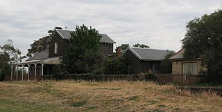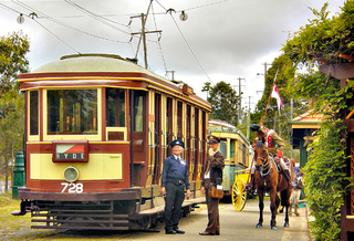
Melton is a suburb in metropolitan Melbourne, Australia. Melton is located 35 km west from the capital's central business district. It is the administrative centre of the City of Melton local government area and its most populous centre. At June 2019 Melton had an urban population of 72,177, and has grown steadily with an average annual rate of 5.01% year-on-year for the five years to 2019. It is considered part of the Greater Melbourne metropolitan area and is included in the capital's population statistical division.

Parkes is a town in the Central West region of New South Wales, Australia. It is the main settlement in the local government area of Parkes Shire. Parkes had a population of 11,224 as at 30 June 2018.

Waterfall is a small suburb in southern Sydney, in the state of New South Wales, Australia. It is 40 kilometres south of the Sydney central business district in the Sutherland Shire. It is the southernmost suburb of Sydney in the eastern corridor, bordering the Illawarra region.

Forbes is a town in the Central West region of New South Wales, Australia, located on the Newell Highway between Parkes and West Wyalong. At the 2016 census, Forbes had a population of 8,432. Forbes is probably named after Sir Francis Forbes, first Chief Justice of NSW.

Sunshine is a suburb of Melbourne, Australia, 12 km west of the CBD, located within the City of Brimbank local government area. Sunshine recorded a population of 9,768 at the 2016 census.

The Eastern Suburbs & Illawarra Line is a commuter railway line in the eastern and southern suburbs of Sydney and is a part of the Sydney Trains network. The line was constructed in the 1880s to Wollongong to take advantage of agricultural and mining potentials in the Illawarra area. In March 1926, it became the first railway in New South Wales to run electric train services.

Bannockburn is a rural township near Geelong, Victoria, Australia, 88 km southwest of Melbourne. It is located in Golden Plains Shire. In the 2016 census, Bannockburn had a population of 5,283.

Leongatha is a town in the foothills of the Strzelecki Ranges, South Gippsland Shire, Victoria, Australia, located 135 kilometres (84 mi) south-east of Melbourne. At the 2016 census, Leongatha had a population of 5,119.

Strathmerton is a town in Victoria, Australia.

Loftus is a suburb, in southern Sydney, in the state of New South Wales, Australia. Loftus is 29 kilometres south of the Sydney central business district, in the local government area of the Sutherland Shire.

Cowan is a small town and suburb near Sydney, in the state of New South Wales, Australia, approximately 40 kilometres (25 mi) north of the Sydney central business district, in the local government area of Hornsby Shire. Cowan shares the postcode of 2081 with Berowra. Brooklyn, which lies 6 kilometres (3.7 mi) to the north-east of Cowan, is considered the northernmost suburb of the Greater Sydney Metropolitan Area.

Korumburra is a heritage listed railway station on the former South Gippsland line in South Gippsland, Victoria, Australia. Passenger operations on the line ceased beyond Cranbourne station in July 1993. The station was part of the South Gippsland tourist railway between 1994 and 2015 but is no longer in use.

Leongatha is a railway station in the town of Leongatha, Victoria on the former South Gippsland railway line in South Gippsland, Victoria, Australia.

Bogan Gate is a small village in Parkes Shire of the Central West of New South Wales, Australia. At the 2011 census, Bogan Gate and the surrounding area had a population of 307. Bogan Gate is derived from the local Aboriginal word meaning "the birthplace of a notable headman of the local tribe".

The Piangil railway line is a 5 ft 3 in gauge (1600 mm) railway line in north-western Victoria, Australia. It branches off the Deniliquin line just north of Bendigo, and runs in a north-westerly direction through Pyramid Hill and Kerang to the border town of Swan Hill, then roughly parallels the New South Wales border to Piangil and Yungera. The line is now open only as far as Piangil, and passenger services only operate to Swan Hill.

Wunghnu is a town in the Goulburn Valley region of northern Victoria, Australia. The town is located in the Shire of Moira local government area, 204 kilometres (127 mi) north of the state capital, Melbourne. The local railway station was opened on the Goulburn Valley railway in 1881, but does not see any passenger services, being the site of a siding and grain silos.

Yuleba is a rural town and locality in the Maranoa Region, in the south-west of Queensland, Australia. In the 2016 census, Yuleba had a population of 207 people.

Jennings is a town on the Northern Tablelands region of New South Wales, Australia. The town is located in the Tenterfield Shire local government area, 718 kilometres (446 mi) from the state capital, Sydney and 256 kilometres (159 mi) from Brisbane. It is separated by the state border from its neighbouring town of Wallangarra in Queensland. At the 2011 census, Jennings had a population of 211. The New England Highway and the Main North railway line cross the state border at Jennings. The town was named for Sir Patrick Jennings, the first Roman Catholic Premier of New South Wales.

Koo Wee Rup is a town in Victoria, Australia, 63 km south-east of Melbourne's Central Business District, located within the Shire of Cardinia local government area. Koo Wee Rup recorded a population of 3,579 at the 2016 census.

Serviceton railway station is located on the Western standard gauge line in Victoria, Australia, in the small town of Serviceton, 461 kilometres by rail from Melbourne. Opened in 1889, and closed in 1986, today it is leased to West Wimmera Shire Council for community group use.


