State Route 120 is located in central California. It runs from the San Joaquin Valley near Lathrop through Yosemite National Park, to its end at U.S. Route 6 in Mono County, eastern California. While the route is signed as a contiguous route through Yosemite National Park, the portion in park boundaries is federally maintained, and is not included in the state route logs. The portion at Tioga Pass is the highest paved through road in the California State Route system. This part is not maintained in the winter and is usually closed during the winter season.

Monarch Pass, elevation 11,312 feet (3,448 m), is a high mountain pass in the Rocky Mountains of south-central Colorado in the United States.
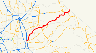
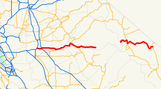
State Route 88, also known as the Carson Pass Highway, is a California State Highway that travels in an east–west direction, from Stockton, crossing the Sierra Nevada at Carson Pass, and ending at the border with Nevada, whereupon it becomes Nevada State Route 88, eventually terminating at U.S. Route 395.

Carson Hill is a ghost town in Calaveras County, California. It sits at an elevation of 1447 feet above sea level and is located at 38°01′42″N120°30′24″W, about 4 miles (6.4 km) south-southeast of Angels Camp. It was one of the most productive mining camps in the state, with nearly $26 million in gold and quartz found in the area. Carson Hill is registered as California Historical Landmark #274. The town was served by the Sierra Railway's branchline to Angels Camp until 1935.
El Dorado, not to be confused with the nearby El Dorado Hills, is an unincorporated community in El Dorado County, California. It is located 4 miles (6.4 km) southwest of Placerville, at an elevation of 1608 feet. The population was 4,096 at the 2000 census. The town is registered as California Historical Landmark #486. The ZIP code is 95623. The community is inside area code 530.
Pulga is an unincorporated community in Butte County, California. It is located along the west slope of the Feather River canyon, at an elevation of 1398 feet. A variant name for the community is Big Bar. Other nearby communities include Mayaro, Poe and Parkhill. The town hosts a Caltrans highway maintenance station along State Route 70 (SR70). The place is at the mouth of the Flea Valley Creek, which gives rise to the toponym.
Panamint Springs is an unincorporated community in Inyo County, California. It lies at an elevation of 1926 feet.
Twin Bridges is a small unincorporated community on U.S. Route 50 near the Desolation Wilderness in El Dorado County, California. It is located 5 miles (8 km) west of Echo Summit, at an elevation of 6,115 feet (1,864 m). It has a population of 14 people according to census figures, however, as of 2008 the road sign lists the population at 10. Right after the town, the U.S. 50 eastbound starts a steep ascent to Echo Summit passing Sierra-at-Tahoe ski resort shortly before the summit.
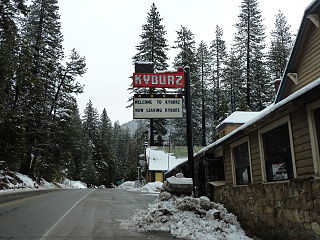
Kyburz is a small unincorporated community in El Dorado County, California. It is located along the South Fork of the American River and U.S. Route 50, and is surrounded by the Eldorado National Forest. Its elevation is 4058 feet above sea level.

Meyers is a small unincorporated community in El Dorado County, California, United States, along U.S. Route 50 in the northern Sierra Nevada mountains 6 miles south of South Lake Tahoe in the Lake Tahoe area. It lies at an elevation of 6,352 feet. Established in 1851, Meyers started out as a stagecoach stop, trading post and Pony Express station. The town is now registered as California Historical Landmark #708. It serves as a popular stop on the way into and out of the Tahoe Basin for travelers on Highways 50 and 89.
Riverton is a small unincorporated community in El Dorado County, California. It is located on the South Fork of the American River 8.5 miles (14 km) west of Kyburz, at an elevation of 3238 feet. The ZIP code is 95726. The community is inside area code 530.
Pacific is a small unincorporated community in El Dorado County, California. It is located 3.25 miles (5 km) east of Pollock Pines, at an elevation of 3396 feet. It lies along U.S. Highway 50 and is next to the town of Pacific House, California. The ZIP code is 95726. The community is inside area code 530.
Fresh Pond is a small unincorporated community in El Dorado County, California. It is located 3 miles (4.8 km) east of Pollock Pines, at an elevation of 3606 feet. The ZIP code is 95726. The community is inside area code 530. It is nestled along Highway 50 and offers a convenient gas station by the road.
Kit Carson is an unincorporated community in Amador County, California, United States. The town is named after famous explorer Kit Carson. It is located at the north end of Silver Lake in the Eldorado National Forest. It lies at an elevation of 7,287 feet. Kit Carson's first post office was established in 1951. It has the zip code of 95644.
Tragedy Spring is a small alpine freshwater spring and a former settlement in eastern Amador County, California adjacent to Highway 88 approximately two miles west of Silver Lake. It was named after an incident on June 27, 1848, in which three Mormon men were killed adjacent to the spring, allegedly by Native Americans, and their bodies burned and buried. The names of the men were carved on a large tree in this location.
Balderson Station is an unincorporated community in El Dorado County, California. It is located 5 miles (8 km) east-northeast of Georgetown, at an elevation of 3294 feet.
Melsons Corner is an unincorporated community in El Dorado County, California. It is located 4 miles (6.4 km) east-northeast of Aukum, at an elevation of 2087 feet.

Council Grove Lake is a reservoir on the Neosho River in east-central Kansas. Built and managed by the U.S. Army Corps of Engineers, it is used for flood control, recreation, and water supply.
Silver Fork American River is a tributary of the South Fork American River in the Sierra Nevada near Lake Tahoe in Northern California.


