
Lake Athabasca is in the north-west corner of Saskatchewan and the north-east corner of Alberta between 58° and 60° N in Canada. The lake is 26% in Alberta and 74% in Saskatchewan.

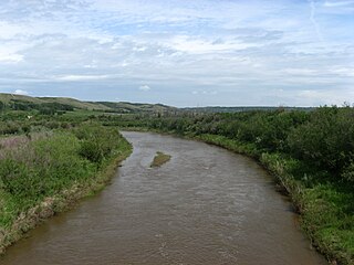
The Qu'Appelle River is a river in the Canadian provinces of Saskatchewan and Manitoba that flows 430 kilometres (270 mi) east from Lake Diefenbaker in south-western Saskatchewan to join the Assiniboine River in Manitoba, just south of Lake of the Prairies, near the village of St. Lazare. It is in a region called the Prairie Pothole Region of North America, which extends throughout three Canadian provinces and five U.S. states. It is also within Palliser's Triangle and the Great Plains ecoregion.

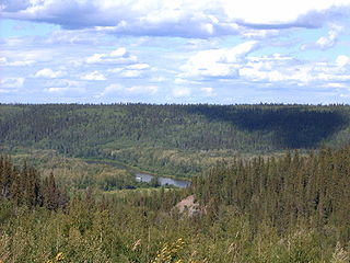
The Churchill River is a major river in Alberta, Saskatchewan and Manitoba, Canada. From the head of the Churchill Lake it is 1,609 kilometres (1,000 mi) long. It was named after John Churchill, 1st Duke of Marlborough and governor of the Hudson's Bay Company from 1685 to 1691. The Cree name for the river is Missinipi, meaning "big waters". The Denesuline name for the river is des nëdhë́, meaning "Great River".
The Clearwater River is located in the Canadian provinces of Saskatchewan and Alberta. It rises in the northern forest region of north-western Saskatchewan and joins the Athabasca River in north-eastern Alberta. It was part of an important trade route during the fur trade era and has been designated as a Canadian Heritage River.

The Red Deer River is a river in Alberta and a small portion of Saskatchewan, Canada. It is a major tributary of the South Saskatchewan River and is part of the larger Saskatchewan / Nelson system that empties into Hudson Bay.
Battle River is a river in central Alberta and western Saskatchewan, Canada. It is a major tributary of the North Saskatchewan River.

Wollaston Lake is a lake in the north-eastern part of the Canadian province of Saskatchewan. It is about 550 kilometres (340 mi) north-east of Prince Albert. With a surface area of 2,286 square kilometres (883 sq mi), it is the largest bifurcation lake in the world — that is, a lake that drains naturally in two directions.

The geography of Saskatchewan is unique among the provinces and territories of Canada in some respects. It is one of only two landlocked regions and it is the only region whose borders are not based on natural features like lakes, rivers, or drainage divides. The borders of Saskatchewan, which make it very nearly a trapezoid, were determined in 1905 when it became a Canadian province. Saskatchewan has a total area of 651,036 square kilometres (251,366 sq mi) of which 591,670 km2 (228,450 sq mi) is land and 59,366 km2 (22,921 sq mi) is water.
Highway 980 is a provincial highway in the east central region of the Canadian province of Saskatchewan. It runs from Highway 3 near Armit until it transitions into Range Road 1304 at its southern terminus but not before passing through the Woody River Recreation Site and the community of Elbow Lake. It also connects with Highway 981. It is about 53 kilometres (33 mi) long.
Highway 999 is a provincial highway in the far north region of the Canadian province of Saskatchewan. It is split in two sections and serves the small settlement of Camsell Portage and Charlot River Airport on the north side of Lake Athabasca. The western section of the highway is about 2 kilometres (1.2 mi) long and serves Camsell Portage, which is the northern-most settlement in Saskatchewan, and Camsell Portage Airport. The eastern section is about 12.3 kilometres (7.6 mi) long and runs from Charlot River Airport on the shore of Lake Athabasca east to Dam Lake. The highway provides access to the three Athabasca System Hydroelectric Stations.

Last Mountain Lake, also known as Long Lake, is a prairie lake formed from glaciation 11,000 years ago. It is located in south central Saskatchewan, Canada, about 40 kilometres (25 mi) north-west of the city of Regina. It flows into the Qu'Appelle River via Last Mountain Creek, which flows past Craven. It is approximately 93 km (58 mi) long, and 3 km (1.9 mi) wide at its widest point. It is the largest naturally occurring body of water in southern Saskatchewan. Only Lake Diefenbaker, which is man-made, is larger. The lake is a popular resort area for residents of south-eastern Saskatchewan.

Geikie River is a river in the northern part of the Canadian province of Saskatchewan. The river's source is Costigan Lake, which is near the uranium producing areas around the Key Lake mine in the Athabasca Basin. It flows in a north-easterly direction and flows into Wollaston Lake.
The Cochrane River is a river in Canadian provinces of Manitoba and Saskatchewan. Located in the boreal forest of the Canadian Shield, it flows from Wellbelove Bay on the northern end of Wollaston Lake in north-eastern Saskatchewan to the north-east end of Reindeer Lake in Manitoba. The river has a drainage basin of 28,400 square kilometres (11,000 sq mi) and is part of the Churchill River drainage basin.
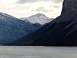
Mount Costigan is a 2,973-metre (9,754-foot) summit in Alberta, Canada.
Rivers Provincial Park is a provincial park in the Canadian province of Manitoba, designated by the Government of Manitoba in 1961. The park is .86 square kilometres (0.33 sq mi) in size and is considered to be a Class III protected area under the IUCN protected area management categories.
The Nemei River is a tributary of the Churchill River. It rises in Nemei Lake and flows northward to join Churchill River near Sandy Bay. It runs through low relief terrain of the Canadian Shield. The climate is sub-arctic.

English River 192H is an Indian reserve of the English River First Nation in Saskatchewan. It is an island in Porter Lake.

Flatstone Lake 192L is an Indian reserve of the English River First Nation in Saskatchewan.

