
Cookbury is a village and civil parish in the local government district of Torridge, Devon, England. The parish, which lies about five miles east of the town of Holsworthy, is surrounded clockwise from the north by the parishes of Thornbury, Bradford, Ashwater, Hollacombe, and Holsworthy Hamlets. In 2001 its population was 158, little changed from the 146 residents it had in 1901.
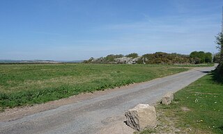
Kelly Rounds, or Castle Killibury is an Iron Age hill fort in Cornwall, England, United Kingdom. It is situated beside the A39 trunk road approximately two miles east of Wadebridge.

Ludgvan is a civil parish and village in Cornwall, England, UK, 2+1⁄2 miles (4.0 km) northeast of Penzance. Ludgvan village is split between Churchtown, on the hill, and Lower Quarter to the east, adjoining Crowlas. For the purposes of local government, Ludgvan elects a parish council every four years; the town elects a member to Cornwall Council under the Ludgvan division.

Advent is a civil parish on the north-western edge of Bodmin Moor in north Cornwall, England. The English name St Adwenna derives from the Cornish Adhwynn and lies in the Registration District of Camelford.

Gunwalloe is a coastal civil parish in Cornwall, England, United Kingdom. It is situated on the Lizard Peninsula three miles (4.8 km) south of Helston and partly contains The Loe, the largest natural freshwater lake in Cornwall. The parish population including Berepper at the 2011 census was 219. The hamlets in the parish are Chyanvounder, Berepper and Chyvarloe. To the east are the Halzephron cliffs and further east the parish church.

Pencarrow is a Grade II*-listed country house in the civil parish of Egloshayle, in north Cornwall, England, United Kingdom. It is situated three miles (5 km) east-southeast of Wadebridge and three miles (5 km) north-northwest of Bodmin.

Egloshayle is a civil parish and village in north Cornwall, England, United Kingdom. The village is beside the River Camel, southeast of Wadebridge. The civil parish stretches southeast from the village and includes Washaway and Sladesbridge.
St Tudy is a civil parish and village in north Cornwall, England, United Kingdom. The village is situated in the River Camel valley approximately five miles northeast of Wadebridge.

Mawnan is a village and civil parish in south Cornwall, England, United Kingdom. It is in the former administrative district of Kerrier and is bounded to the south by the Helford River, to the east by the sea, and to the west by Constantine parish. The population was 1,454 in the 2001 census, rising slightly to 1,476 at the 2011 census. The church town of the parish is Mawnan Church, also known simply as Mawnan, and the only large village in the parish is Mawnan Smith, approximately three miles south of Falmouth.

Grade–Ruan is a civil parish on the Lizard peninsula in Cornwall, England, United Kingdom, approximately ten miles (16 km) south of Falmouth.
St Anthony-in-Meneage is a coastal civil parish and village in Cornwall, England, United Kingdom. The parish is in the Meneage district of the Lizard peninsula. In the 2001 census the parish had a population of 171, decreasing to 168 at the 2011 census.

St Endellion is a civil parish and hamlet in north Cornwall, England, United Kingdom. The hamlet and parish church are situated four miles (6.5 km) north of Wadebridge.

Polbrock is a small hamlet in north Cornwall, England, United Kingdom. It is situated two miles southeast of Wadebridge at grid reference SX 014 695 and near Burlorne Pillow.

Bodgate is a farmstead in east Cornwall, England, United Kingdom. It is situated in North Petherwin civil parish about 0.5 miles (0.80 km) south of North Petherwin village, five miles (8 km) north-west of Launceston. The parish was transferred from Devon to Cornwall in 1966.

Burlawn is a hamlet in the parish of St Breock, Cornwall, England, UK.
Kelly is a hamlet in the parish of Egloshayle, Cornwall, England.
Lane-end is a hamlet in the parish of Egloshayle, Cornwall, England. It is in the civil parish of St Mabyn

Rosenannon is a hamlet in Cornwall, England, United Kingdom. It is within the civil parish of St Wenn, 4 miles (6.4 km) south-west of the town of Wadebridge.
Treveneague is an area near Goldsithney, Penzance, in the civil parish of St Hilary. It was originally composed of two places, North Treveneague and South Treveneague. The Grade II listed early 19th century North Treveneague Farmhouse and Farm Buildings North of Treveneague Farmhouse are located here. In the 1860s, an Iron Age fogou was discovered at Treveneague.

Arrallas was a manorial settlement recorded in the Domesday book, when in 1086 it had seven households and three ploughlands. It is located in the parish of St Enoder in Cornwall, England. Its name derives from the Cornish language words arghans and lys meaning "silver court", with the lys likely denoting a site of royal importance.
