Related Research Articles
Hensbarrow Beacon is a hill in Cornwall, England, United Kingdom. It is situated a mile north-west of Stenalees village at grid reference SW 996 575. It is the highest natural point of the Hensbarrow uplands, a natural region and national character area.

The River Allen in north Cornwall is one of two rivers in Cornwall which share this name. In this case the name is the result of a mistake made in 1888 by Ordnance Survey, replacing the name Layne with Allen which is the old name for the lower reaches of the Camel. The other River Allen runs through Truro.

Condolden is a hill in north Cornwall, England, UK. The summit is 308 metres above ordnance datum.

The De Lank River is a small river in north Cornwall, England. It is a tributary of the River Camel and is approximately nine miles (14.5 km) long from its source on Bodmin Moor to its confluence with the Camel two miles (3 km) south of St Breward.
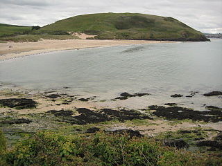
Brea Hill, pronounced "Bray Hill" is a round hill beside the River Camel estuary in north Cornwall, England, United Kingdom The hill is 62 metres (203 ft) high and there are Bronze Age tumuli at the summit. The underlying geology in this area of Cornwall is Devonian slates.

Brill is a village in south-west Cornwall, England, UK. It is located within the civil parish of Constantine, 1 kilometre (0.62 mi) north-west of the village of the same name.

Congdon's Shop is a hamlet in the parish of North Hill, Cornwall, England. It is at the junction of the B3254 Launceston to Liskeard road and the B3257 road from Plusha to Callington.

Higher Menadew is a farm west of Luxulyan in Cornwall, England.
Kelly is a hamlet in the parish of Egloshayle, Cornwall, England.

Kerthen Wood, or Kirthen Wood, is a hamlet near Townshend in Cornwall, England. It is in the civil parish of Crowan

Maders is a hamlet west of Kelly Bray in the parish of South Hill in east Cornwall, England.
Mornick is a hamlet in the parish of South Hill, Cornwall, England.
Muchlarnick is a hamlet in Cornwall, England. It is about two miles east of Lanreath in the civil parish of Pelynt.
Penelewey is a hamlet southeast of Playing Place in Cornwall, England, UK. Penelewey is on the B3289 road.
Pengegon is a residential area east of Camborne, Cornwall, England, which has a fish and chip shop, a playground and memorial to local teen Shakira Pellow. From 2013 to 2021, Pengegon was included in the Camborne Treslothan division on Cornwall Council. After boundary changes at the 2021 local elections, it was placed in the new Four Lanes, Beacon and Troon division.
Penrose Hill is a hamlet near Porthleven, Cornwall, England, UK.

Trefanny Hill is a hamlet in the parish of Duloe, Cornwall, England, United Kingdom. The hamlet was formerly called Hille or Hill.

Hawk's Tor is a hill and tor on Bodmin Moor in Cornwall, England, UK. Its summit is 307 metres (1,007 ft) above sea level.

Trevaunance Cove is a small bay on the north Cornish coast and a residential area of St Agnes, Cornwall, United Kingdom. In the 18th and 19th centuries it was a busy harbour despite storms often destroying the quay. The South West Coast Path passes over the coastal slope to the north.

The River Seaton is a river in east Cornwall, England, UK which flows southwards for 11 miles (17 km) into the English Channel.
References
- ↑ Ordnance Survey: Landranger map sheet 204 Truro & Falmouth (Map). Ordnance Survey. 2009. ISBN 978-0-319-23290-3.
- ↑ Cox Hill; Explore Britain
| Unitary authorities | |
|---|---|
| Major settlements |
|
| Rivers | |
| Topics | |
Coordinates: 50°15′03″N5°10′18″W / 50.2509°N 5.1718°W
| | This article about a location in the former district of Carrick, Cornwall is a stub. You can help Wikipedia by expanding it. |