Coxipi River

Last updated • 5 min readFrom Wikipedia, The Free Encyclopedia
Coxipi River
Rivière Coxipi
Canada Quebec relief location map.jpg
Red pog.svg
Native nameKak Sipi  (Innu)
Location
CountryCanada
ProvinceQuebec
Region Côte-Nord
RCM Le Golfe-du-Saint-Laurent
Physical characteristics
Mouth Gulf of Saint Lawrence
  coordinates
51°18′16″N58°28′51″W / 51.3044444°N 58.4808333°W / 51.3044444; -58.4808333 Coordinates: 51°18′16″N58°28′51″W / 51.3044444°N 58.4808333°W / 51.3044444; -58.4808333
  elevation
0 metres (0 ft)
Length128 kilometres (80 mi)
Basin size1,672 square kilometres (646 sq mi)

The Coxipi River (French : Rivière Coxipi) is a salmon river in the Côte-Nord region of Quebec, Canada. It flows south through Quebec from Labrador and empties into the Gulf of Saint Lawrence.

Contents

Location

The main channel of the river is about 128 kilometres (80 mi) long, of which 20 kilometres (12 mi) is in Labrador. The river has a Strahler number of 6. The headwaters of the river rise at about 405 metres (1,329 ft). The river drops by more than 240 metres (790 ft) in its first 30–40 kilometres (19–25 mi). [1] It is fed by Lake Poincarré. The 11 square kilometres (4.2 sq mi) Lake Coxipi is long and narrow, essentially a widening of the Coxipi River. [2] The mouth of the river is in the municipality of Saint-Augustin in Le Golfe-du-Saint-Laurent Regional County Municipality. [3] It is about 15 kilometres (9.3 mi) from the village of Saint-Augustin. [4]

Name

The 1914 and 1925 editions of the Dictionnaire des rivières et lacs de la province de Québec call the river Léandre River. [2] That name is said to come from a fisherman named Léandre who was based at its mouth for many years. [5] The 1921 Noms géographiques de la province de Québec gives Léandre River as the official name, and refers Coxipi River to Léandre River. In 1948 the Quebec Geography Commission accepted Coxipi as the official name. The name "Coxipi" comes from the Innu language name Kak Sipi, which means "porcupine river". Some sources say that coxipi means "sorcerer". [2]

Description

The Dictionnaire des rivières et lacs de la province de Québec (1914) says of the Léandre River,

Situated on the north coast of the Saint Lawrence, Saguenay County, 14 miles from Shecatica Bay, in the canton of Bougainville. Its name comes from a fisherman called Léandre who exploited this river at its mouth for many years. The savages used to call it Coxipi. This watercourse, about 60 miles long, flows into the sea in a rapid one mile long. According to the surveyor H. Bellanger (1912) the river is excellent for floating wood. The land in the area is unsuitable for cultivation and lightly wooded. This river contains trout and salmon in abundance. It is also excellent hunting territory and is frequently visited by the savages. The river Léandre receives the waters of several beautiful lakes enclosed in mountains with a height of 100 or 200 feet. Its main tributaries are the Est River and the Petite River. [5]

Basin

The Coxipi River basin covers 1,672 square kilometres (646 sq mi). [6] Of this 130 square kilometres (50 sq mi) is in Labrador. [1] It lies between the basins of the Saint-Augustin River to the west and the Chécatica River to the east. [6] The Quebec portion is partly in the unorganized territory of Petit-Mécatina and partly in the municipality of Saint-Augustin. [7] The average elevation of the watershed in 249 metres (817 ft), rising to a maximum of 503 metres (1,650 ft). The river basin include part of the proposed Basses Collines du Lac Guernesé Biodiversity Reserve. [8] This would protect the area from hydroelectric development. [9]

Environment

A map of the ecological regions of Quebec shows the Coxipi River in sub-regions 6o-T, 6n-T and 6m-T of the east spruce/moss subdomain. [10] About 80.6% of the watershed is forest covered, with just 3.1% covered in shrubs or grassland. [1] 9.6% of the watershed in water and 1.2% wetlands. Annual daily mean temperatures are 0–1.2 °C (32.0–34.2 °F), ranging from −16.5 to −12.8 °C (2.3 to 9.0 °F) in January to 13.9 to 15.2 °C (57.0 to 59.4 °F) in July. Average annual precipitation is 1,005.4 to 1,122.4 millimetres (39.58 to 44.19 in). [1] Land mammals include black bear, moose, boreal woodland caribou, wolf, lynx, beaver, North American porcupine, mink, hare and red fox. [4]

Fishing

The Coxipi River is recognized as an Atlantic salmon river. [11] There are several fishing holes in the rapids at the river mouth. The salmon mount the river for over 30 kilometres (19 mi). Brook trout are also common. The Pourvoirie Saint-Augustin, an outfitter accessible by boat or floatplane, provides fishing services over a 13 kilometres (8.1 mi) stretch. [4] The Pourvoirie Kecarpoui arranges fishing/camping expeditions that include the Véco, Kécarpoui, Saint-Augustin, Coxipi, Chécatica and Napetipi rivers. [12]

Notes

    1. 1 2 3 4 Hydrology of the Transboundary Rivers, p. 72.
    2. 1 2 3 Lac Coxipi, Commission.
    3. Rivière Coxipi, Natural Resources.
    4. 1 2 3 Rivière Coxipi, Saumon Québec.
    5. 1 2 Rouillard 1914, p. 85.
    6. 1 2 Bourdon et al. 2015, p. 20.
    7. Bourdon et al. 2015, p. 64.
    8. Bourdon et al. 2015, p. 90.
    9. Hydrology of the Transboundary Rivers, p. 73.
    10. Saucier et al. 2011.
    11. Liste des rivières à saumon.
    12. Pourvoirie Kecarpoui.

    Sources

    Related Research Articles

    Magpie River (Quebec)

    The Magpie River is a 200 kilometres (120 mi) river in the Côte-Nord region of Quebec which flows from the Labrador Plateau to empty into the north shore of the Saint Lawrence River east of Sept-Îles, Quebec.

    Little Watshishou River

    The Little Watshishou River is a salmon river in the east of the Côte-Nord region of Quebec, Canada.

    Nabisipi River

    The Nabisipi River is a salmon river in the Côte-Nord region of Quebec, Canada. It flows into the Gulf of Saint Lawrence

    Pigou River

    The Pigou River is a salmon river in the Côte-Nord region of Quebec, Canada. It empties into the Gulf of Saint Lawrence.

    Little Mecatina River

    The Little Mécatina River is a major river in the Côte-Nord region of the provinces of Labrador and Quebec, Canada. Studies have been made to exploit the hydroelectric potential of the river, which could be around 1,200 MW from three dams. The Little Mécatina River was driven first with kayaks by Rolf Theiß and Fritz Gottensrtöter from Guetersloh, Germany.

    Coacoachou River

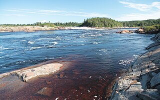
    The Coacoachou River is a river in the Côte-Nord region of Quebec, Canada.

    Véco River

    The Véco River is a salmon river in the Côte-Nord region of Quebec, Canada, that empties into the Gulf of Saint Lawrence. It has been dammed to supply a hydroelectric power plant. The shoreline around the mouth of the river is protected as part of a federal bird sanctuary.

    Saint-Jean River (Minganie)

    The Saint-Jean River is a major tributary of the north shore of the Gulf of St. Lawrence, flowing in the unorganized territory of Lac-Jérôme and in the municipality of Rivière-Saint-Jean, in the Minganie Regional County Municipality, in the administrative region of Côte-Nord, in the province of Quebec (Canada). It is considered one of the three salmon rivers on the North Shore.

    Piashti River

    The Piashti River is a salmon river in the Côte-Nord region of the province of Quebec, Canada. It empties into the Gulf of Saint Lawrence.

    Corneille River

    The Corneille River is a river in the Côte-Nord region of Quebec, Canada. It empties into the Gulf of Saint Lawrence opposite Anticosti Island.

    Sheldrake River (Minganie)

    The Sheldrake River is a river in the Côte-Nord region of Quebec, Canada. It flows into the Gulf of Saint Lawrence. There is a 25 MW hydroelectric power station on the river.

    Aguanish River

    The Aguanish River is a salmon river of the Côte-Nord region of Quebec. It flows from north to south and empties into the Gulf of Saint Lawrence.

    Kegaska River

    The Kegaska River is a salmon river flowing on North shore of Estuary of Saint Lawrence. It crosses the unorganized territory of Petit-Mécatina, in the Le Golfe-du-Saint-Laurent Regional County Municipality, in the administrative region in the Côte-Nord, in the province of Quebec, Canada.

    Saint-Paul River

    The Saint-Paul River is a salmon river in the Côte-Nord region of Quebec, Canada. It empties into the Gulf of Saint Lawrence.

    Saint-Augustin River

    The Saint-Augustin River is a salmon river in the Côte-Nord region of Quebec, Canada. It empties into the Gulf of Saint Lawrence.

    Napetipi River

    The Napetipi River is a salmon river in the Côte-Nord region of Quebec, Canada. It empties into the Gulf of Saint Lawrence.

    Kécarpoui River

    The Kécarpoui River is a salmon river in the Côte-Nord region of Quebec, Canada. It flows south and empties into the Gulf of Saint Lawrence.

    Musquanousse River

    The Musquanousse River is a salmon river in the Côte-Nord region of Quebec, Canada. It flows south and empties into the Gulf of Saint Lawrence.

    Washicoutai River

    The Washicoutai River is a salmon river in the Côte-Nord region of Quebec, Canada. It flows south and empties into the Gulf of Saint Lawrence.

    Lake Magpie

    Lake Magpie is a lake in the Côte-Nord region of the province of Quebec, Canada. It forms the middle part of the Magpie River.