
Surrey Wildlife Trust (SWT) was founded in 1959 as Surrey Naturalists' Trust and it is one of forty-six wildlife trusts covering Great Britain, Northern Ireland, Isle of Man and Alderney. SWT carries out conservation activities on a considerable area of Surrey County Council's large countryside estate and also manages land on behalf of the Ministry of Defence estate. As of 2022 the SWT manages more than 6,000 hectares of land for wildlife and employs more than 100 staff. It had an income of £5.1 million and expenditure of £5.7 million.

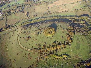
Puttenham and Crooksbury Commons is a 113.8-hectare (281-acre) biological Site of Special Scientific Interest between Farnham and Guildford in Surrey. Puttenham Common is owned by the Hampton Estate and managed on behalf of Surrey County Council. Hillbury Hillfort on Puttenham Common is a scheduled monument. It is a univallate hillfort which probably dates to the Iron Age.

Broadmoor to Bagshot Woods and Heaths is a 1,696.3-hectare (4,192-acre) biological Site of Special Scientific Interest (SSSI) in Berkshire and Surrey that extend from a minority of the parish of Crowthorne including around Broadmoor Hospital in the west to Bagshot south-east, Bracknell north-east, and Sandhurst, south. It is part of the Thames Basin Heaths Special Protection Area. Two nature reserves which are managed by the Surrey Wildlife Trust are in the SSSI, Barossa nature reserve and Poors Allotment. Broadmoor Bottom, which is part of Wildmoor Heath, also falls within the SSSI; this reserve is managed by the Berkshire, Buckinghamshire and Oxfordshire Wildlife Trust.

Colyers Hanger is a 26.6-hectare (66-acre) biological Site of Special Scientific Interest south-east of Guildford in Surrey. It is a Nature Conservation Review site, Grade 2 and is part of St Martha's Hill and Colyer's Hanger nature reserve, which is managed by the Surrey Wildlife Trust.

Combe Bottom is a 42.1-hectare (104-acre) biological Site of Special Scientific Interest north of Shere in Surrey. It is designated a Local Nature Reserve called Shere Woodlands, and is managed by the Surrey Wildlife Trust.
St. Catherine's Hill is a chalk downland hill and 43-hectare (110-acre) biological Site of Special Scientific Interest on the outskirts of Winchester in Hampshire. It is owned by Winchester College but open to the public. It is managed by Hampshire and Isle of Wight Wildlife Trust, and most of it is an Iron Age hillfort, which is a Scheduled Monument.

Ockham and Wisley Commons is a 266-hectare (660-acre) biological Site of Special Scientific Interest east of Woking in Surrey. It is also a Local Nature Reserve and part of the Thames Basin Heaths Special Protection Area. It is part of the slightly larger area of 297-hectare (730-acre) Wisley & Ockham Commons & Chatley Heath nature reserve, which is owned by Surrey County Council and managed by the Surrey Wildlife Trust.

Grangelands and Pulpit Hill is a 25.5-hectare (63-acre) biological Site of Special Scientific Interest in Cadsden in Buckinghamshire. It lies within the Chilterns Area of Outstanding Natural Beauty, and the planning authorities are Wycombe District Council and Buckinghamshire County Council.

Underdown is a 1-hectare (2.5-acre) nature reserve in Farnham in Surrey. It is owned and managed by the Surrey Wildlife Trust.

Bisley and West End Commons is a 37.2-hectare (92-acre) Local Nature Reserve west of Woking in Surrey. It is part of the 46-hectare (110-acre) Bisley & West End Commons and Reidon Hill nature reserve, which is owned by Surrey County Council and managed by Surrey Wildlife Trust. The site is also part of the Colony Bog and Bagshot Heath Site of Special Scientific Interest, the Thursley, Ash, Pirbright & Chobham Special Area of Conservation and the Thames Basin Heaths Special Protection Area,

Chinthurst Hill is a 17.2-hectare (43-acre) Local Nature Reserve south of Guildford in Surrey. It is owned by Surrey County Council and managed by Surrey Wildlife Trust. Chinthurst Hill Tower is a Grade II Scheduled Monument.

Hill Park, Tatsfield is a 24.5-hectare (61-acre) Local Nature Reserve south of Tatsfield in Surrey. It is owned by Surrey County Council and managed by Surrey Wildlife Trust.
Barossa is a 498-hectare (1,230-acre) nature reserve north of Camberley in Surrey. It is owned by the Ministry of Defence and managed by the Surrey Wildlife Trust. It is part of the Thames Basin Heaths Special Protection Area and the Broadmoor to Bagshot Woods and Heaths Site of Special Scientific Interest

Chitty's Common is a 5-hectare (12-acre) nature reserve in Guildford in Surrey. It is owned by Surrey County Council and managed by the Surrey Wildlife Trust.
Deepdene Terrace is a 4-hectare (9.9-acre) nature reserve south-east of Dorking in Surrey. It is owned by Mole Valley District Council and managed by the Surrey Wildlife Trust.

Dollypers Hill is a 12-hectare (30-acre) nature reserve south east of Coulsdon in the London Borough of Croydon. It is managed by the Surrey Wildlife Trust.

Elstead Group of Commons is a 180-hectare (440-acre) nature reserve east of Elstead in Surrey. It is composed of Royal, Elstead and Ockley Commons, which are owned by the Ministry of Defence and managed by the Surrey Wildlife Trust, and Bagmoor Common, which is owned and managed by the Trust. The site is part of Thursley, Hankley and Frensham Commons Special Protection Area and Site of Special Scientific Interest.

Runfold Wood is a 12-hectare (30-acre) nature reserve east of Farnham in Surrey. It is managed by the Surrey Wildlife Trust.

Stringer's Common is a 30-hectare (74-acre) nature reserve east of Worplesdon in Surrey. It is owned by Surrey County Council and managed by the Surrey Wildlife Trust.

Wotton and Abinger Commons is a 324-hectare (800-acre) nature reserve south-west of Dorking in Surrey. It is managed by the Surrey Wildlife Trust. Part of it is in Leith Hill Site of Special Scientific Interest

