Cheam is a suburb of London, England, 10.9 miles (17.5 km) southwest of Charing Cross. It is divided into North Cheam, Cheam Village and South Cheam. Cheam Village contains the listed buildings Lumley Chapel and the 16th-century Whitehall. It is adjacent to two large parks, Nonsuch Park and Cheam Park. Nonsuch Park contains the listed Nonsuch Mansion. Parts of Cheam Park and Cheam Village are in a conservation area. Cheam is bordered by Worcester Park to the northwest, Morden to the northeast, Sutton to the east, Epsom, Ewell and Stoneleigh to the west and Banstead and Belmont to the south.

The London Borough of Sutton is an Outer London borough in south-west London, England. It covers an area of 43 km2 (17 sq mi) and is the 80th largest local authority in England by population. It borders the London Borough of Croydon to the east, the London Borough of Merton to the north and the Royal Borough of Kingston upon Thames to the north-west; it also borders the Surrey boroughs of Epsom and Ewell to the west and Reigate and Banstead to the south. The local authority is Sutton London Borough Council. Its principal town is the eponymous Sutton.

Reigate and Banstead is a local government district with borough status in east Surrey, England. It includes the towns of Reigate, Redhill, Horley and Banstead. The borough borders the Borough of Crawley to the south, the Borough of Epsom and Ewell and District of Mole Valley to the west, Tandridge District to the east and the London Boroughs of Sutton and Croydon to the north.

Epsom is a town in the Borough of Epsom and Ewell in Surrey, England, about 14 miles south of central London. The town is first recorded as Ebesham in the 10th century and its name probably derives from that of a Saxon landowner. The earliest evidence of human activity is from the mid-Bronze Age, but the modern settlement probably grew up in the area surrounding St Martin's Church in the 6th or 7th centuries and the street pattern is thought to have become established in the Middle Ages. Today the High Street is dominated by the clock tower, which was erected in 1847–8.

Epsom and Ewell is a local government district with borough status in Surrey, England, covering the towns of Epsom and Ewell. The borough was formed as an urban district in 1894, and was known simply as Epsom until 1934. It was made a municipal borough in 1937. The district was considered for inclusion in Greater London in 1965 but was left unaltered by the London Government Act 1963 and the Local Government Act 1972 in 1974. However, despite being outside modern Greater London the borough was in the Metropolitan Police District until it was transferred to Surrey Police in 2000. In the May 2019 elections, the borough was held by the Epsom and Ewell Residents Association with 32 seats, Labour with 3 seats, Liberal Democrats with 2 seats, and Conservatives with 1 seat. On March 20, 2023, the borough was held by the Epsom and Ewell Residents Association with 31 seats, Labour with 3 seats, Liberal Democrats with 2 seats, Conservatives with 1 seat and 1 seat vacant.

The A24 is a major road in England that runs for 53.2 miles (85.6 km) from Clapham in south-west London to Worthing on the English Channel in West Sussex via the suburbs of south-west London, as well as through the counties of Surrey and West Sussex.

Surrey Wildlife Trust (SWT) was founded in 1959 as Surrey Naturalists' Trust and it is one of forty-six wildlife trusts covering Great Britain, Northern Ireland, Isle of Man and Alderney. SWT carries out conservation activities on a considerable area of Surrey County Council's large countryside estate and also manages land on behalf of the Ministry of Defence estate. As of 2022 the SWT manages more than 6,000 hectares of land for wildlife and employs more than 100 staff. It had an income of £5.1 million and expenditure of £5.7 million.
Epsom was a borough constituency represented in the House of Commons of the Parliament of the United Kingdom. It elected one Member of Parliament (MP) by the first past the post system of election. From its creation in 1885 until its abolition in 1974, it was won by eight Conservatives. The winner took less than 50% of the votes in its contested elections once, in 1945, receiving 49.9% of the vote in a three-party contest. Six elections, the last being a by-election in 1912, were uncontested.

Ewell is a town in the Borough of Epsom and Ewell in Surrey, England. It is approximately 12 miles (19 km) south of central London and 2 miles (3.2 km) northeast of Epsom. In the 2011 Census, the town had a population of 34,872. The majority of which (73%) is in the ABC1 social class, except the Ruxley Ward that is C2DE.

Worcester Park is a suburban town in South West London, England. It lies in the London boroughs of Sutton and Kingston, and partly in the Surrey borough of Epsom and Ewell. The area is 10.1 miles (16.3 km) southwest of Charing Cross. The suburb's population was 16,031 at the time of the 2001 census. The suburb comprises the Worcester Park ward, an electoral area of the London Borough of Sutton with a population in 2011 of 11,655, as well as the Cuddington ward, an electoral area of Epsom and Ewell, which had a population of 5,791 at the time of the 2001 census.
Stoneleigh is a suburban area southwest of London, situated in the north of the Epsom and Ewell borough in the county of Surrey, England. It is situated approximately 11 miles (18 km) from central London. In the 2011 Census, the population was 8,741.

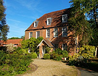
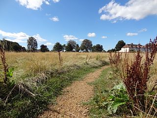
Nonsuch Park is a public park between Stoneleigh, Cheam, and Ewell in the borough of Epsom and Ewell in Surrey, England. It borders the London Borough of Sutton. It is the last surviving part of the Little Park of Nonsuch, a deer hunting park established by Henry VIII surrounding the former Nonsuch Palace.
Horton is a semi-rural area with a village centre in the west of the borough of Epsom and Ewell, in the English county of Surrey. It is situated between the settlements of Epsom, West Ewell, Chessington and Malden Rushett. Its principal road is Horton Lane, which runs the length of the area between West Ewell and Epsom Common. Horton covers the west part of the KT19 postcode which comes under part of the Epsom postal area. Horton Country Park also runs along the length of the area, between Epsom Common and West Ewell.

Horton Country Park is a 152.3-hectare (376-acre) Local Nature Reserve north-west of Epsom in Surrey. It is owned and managed by Epsom and Ewell Borough Council.

Epsom Common is a 177.4-hectare (438-acre) Local Nature Reserve in Epsom in Surrey. It is owned and managed by Epsom and Ewell Borough Council. It is part of Epsom and Ashtead Commons, a Site of Special Scientific Interest.
Sutton Common is the name of former common land and a district and neighbourhood located in Sutton, London. The area is mostly located within the London Borough of Sutton, with some of the streets to the north and west of Sutton Common Park adjoining Lower Morden and Morden within the London Borough of Merton. Much of the area is taken up by the large Kimpton Park commercial and industrial estate, adjoining the A217. It is served by Sutton Common railway station. The area to the south and east of Oldfields Road uses an SM1 postcode and the area to the north and west uses SM3.

Howell Hill is a 5-hectare (12-acre) nature reserve east of Ewell in Surrey. It is owned by Surrey County Council and managed by the Surrey Wildlife Trust.

Nower Wood is a 33-hectare (81-acre) nature reserve south-west of Leatherhead in Surrey. It is owned and managed by Surrey Wildlife Trust.


