
Surrey Wildlife Trust (SWT) was founded in 1959 as Surrey Naturalists' Trust and it is one of forty-six wildlife trusts covering Great Britain, Northern Ireland, Isle of Man and Alderney. SWT carries out conservation activities on a considerable area of Surrey County Council's large countryside estate and also manages land on behalf of the Ministry of Defence estate. As of 2022 the SWT manages more than 6,000 hectares of land for wildlife and employs more than 100 staff. It had an income of £5.1 million and expenditure of £5.7 million.

Colyers Hanger is a 26.6-hectare (66-acre) biological Site of Special Scientific Interest south-east of Guildford in Surrey. It is a Nature Conservation Review site, Grade 2 and is part of St Martha's Hill and Colyer's Hanger nature reserve, which is managed by the Surrey Wildlife Trust.

Epsom Common is a 177.4-hectare (438-acre) Local Nature Reserve in Epsom in Surrey. It is owned and managed by Epsom and Ewell Borough Council. It is part of Epsom and Ashtead Commons, a Site of Special Scientific Interest.

Totternhoe Knolls is a 13.1-hectare (32-acre) Site of Special Scientific Interest (SSSI) in Totternhoe in Bedfordshire. It is also a local nature reserve, and part of the Chilterns Area of Outstanding Natural Beauty. The site is owned by Central Bedfordshire Council and leased to the National Trust. Most of the site is maintained jointly by the National Trust and the Wildlife Trust for Bedfordshire, Cambridgeshire and Northamptonshire (WTBCN), and is part of the WTBCN Totternhoe nature reserve, which also includes Totternhoe Chalk Quarry and Totternhoe Stone Pit. The SSSI also includes Totternhoe Castle, the earthworks of a Norman motte-and-bailey castle which is a Scheduled monument.
Deacon Hill SSSI is a 35.4-hectare (87-acre) biological Site of Special Scientific Interest in Pegsdon in Bedfordshire. It is in the Chilterns Area of Outstanding Natural Beauty, and it is part of the Pegsdon Hills and Hoo Bit nature reserve, managed by Wildlife Trust for Bedfordshire, Cambridgeshire and Northamptonshire.

Grangelands and Pulpit Hill is a 25.5-hectare (63-acre) biological Site of Special Scientific Interest in Cadsden in Buckinghamshire. It lies within the Chilterns Area of Outstanding Natural Beauty, and the planning authorities are Wycombe District Council and Buckinghamshire County Council.

Hollowhill and Pullingshill Woods is a 23-hectare biological Site of Special Scientific Interest near Marlow in Buckinghamshire. It is in the Chilterns Area of Outstanding Natural Beauty, and the Chilterns Beechwoods Special Area of Conservation. The local planning authorities are Wycombe District Council and Buckinghamshire County Council. Pullingshill Wood is owned by the Woodland Trust, and Hollowhill Wood was formerly owned by Buckinghamshire County Council, but was transferred to the Berkshire, Buckinghamshire and Oxfordshire Wildlife Trust. Since November 2015 the 7.8-hectare site has been managed by the Trust as "Hog and Hollowhill Woods".

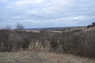
Pewley Down is a 9.5-hectare (23-acre) Local Nature Reserve on the southern outskirts of Guildford in Surrey, adjacent to Pewley Hill. It is owned and managed by Guildford Borough Council. The site is on a hill offering views south to St Martha's Hill, Chantry Wood, and beyond.

Bisley and West End Commons is a 37.2-hectare (92-acre) Local Nature Reserve west of Woking in Surrey. It is part of the 46-hectare (110-acre) Bisley & West End Commons and Reidon Hill nature reserve, which is owned by Surrey County Council and managed by Surrey Wildlife Trust. The site is also part of the Colony Bog and Bagshot Heath Site of Special Scientific Interest, the Thursley, Ash, Pirbright & Chobham Special Area of Conservation and the Thames Basin Heaths Special Protection Area,

Chinthurst Hill is a 17.2-hectare (43-acre) Local Nature Reserve south of Guildford in Surrey. It is owned by Surrey County Council and managed by Surrey Wildlife Trust. Chinthurst Hill Tower is a Grade II Scheduled Monument.

Hill Park, Tatsfield is a 24.5-hectare (61-acre) Local Nature Reserve south of Tatsfield in Surrey. It is owned by Surrey County Council and managed by Surrey Wildlife Trust.

Ash Ranges is a 1,392-hectare (3,440-acre) nature reserve west of Pirbright in Surrey. It is owned by the Ministry of Defence and managed by the Surrey Wildlife Trust. It is part of the Thames Basin Heaths Special Protection Area and the Ash to Brookwood Heaths Site of Special Scientific Interest

Betchworth Quarry and Lime Kilns is a 27-hectare (67-acre) nature reserve north of Betchworth in Surrey. Betchworth Quarry only is managed by Surrey Wildlife Trust. It is part of the Mole Gap to Reigate Escarpment Site of Special Scientific Interest and Special Area of Conservation.

Chitty's Common is a 5-hectare (12-acre) nature reserve in Guildford in Surrey. It is owned by Surrey County Council and managed by the Surrey Wildlife Trust.

Crooksbury Hill is a 17.2-hectare (43-acre) nature reserve within Puttenham and Crooksbury Commons east of Farnham in Surrey. It is owned by Surrey County Council and managed by the Surrey Wildlife Trust. Soldier's Ring on the north side of the hill is a Scheduled Monument. It is a hillfort dating to the late Bronze Age or early Iron Age.

Dawcombe is a 23-hectare (57-acre) nature reserve north-west of Reigate in Surrey. It is managed by the Surrey Wildlife Trust. It is part of the Mole Gap to Reigate Escarpment Site of Special Scientific Interest and Special Area of Conservation.

Inholms Clay Pit is a 8.4-hectare (21-acre) Local Nature Reserve south of Dorking in Surrey. It is owned by Mole Valley District Council and from 2009 - 2019 was managed by Surrey Wildlife Trust and since then by Mole Valley District Council.

Littlefield Common is a 17-hectare (42-acre) nature reserve south-west of Worplesdon in Surrey. It is owned by Surrey County Council and managed by the Surrey Wildlife Trust.

Wallis Wood is a 14-hectare (35-acre) nature reserve south-east of Ewhurst in Surrey. It is managed by the Surrey Wildlife Trust.

Wotton and Abinger Commons is a 324-hectare (800-acre) nature reserve south-west of Dorking in Surrey. It is managed by the Surrey Wildlife Trust. Part of it is in Leith Hill Site of Special Scientific Interest

