
Kelly Bray is a village in east Cornwall, England, United Kingdom. It is situated one mile (1.6 km) north of Callington, immediately west of Kit Hill in a former mining area. Kelly Bray is in the parish of Callington and lies within the St Dominick, Harrowbarrow and Kelly Bray division on Cornwall Council. The population was 3,949 at the 2011 census. Kelly Bray is first recorded ca. 1286 as Kellibregh.

Indian Queens is a village in Cornwall, England, United Kingdom. The village, which is on the A30 trunk road, is in the civil parish of St Enoder. It is situated west of Goss Moor and north of Fraddon, approximately 10 mi (16 km) west-southwest of Bodmin. Black Cross is a nearby hamlet.

St Day is a civil parish and village in Cornwall, England, United Kingdom. It is positioned between the village of Chacewater and the town of Redruth. The electoral ward St Day and Lanner had a population of 4,473 according to the 2011 census.

Crowlas is a village in Cornwall, England, on the A30 about three miles east of Penzance. It forms a small conurbation with Ludgvan within the parish of the same name. The hamlet of Whitecross lies to the north. Details of the crosses at Crowlas and Whitecross are included in the article Ludgvan. There are many small businesses, Chinese Takeway, shop, and the Star Inn pub has a good reputation for local beers. The Methodist Chapel in Chapel square is a modern friendly place that hosts many community activities. The local community radio station Coast FM broadcasts on 96.5 and 97.2 FM.

St Goran is a coastal civil parish in Cornwall, England, UK, six miles (10 km) south-southwest of St Austell. The largest settlement in the parish is the coastal village of Gorran Haven, a mile to the east with a further cluster of homes at Trevarrick. The population at the 2011 census was 1,411.
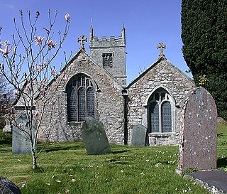
Colan is a village and civil parish in mid-Cornwall, England, United Kingdom. It is situated approximately three miles (5 km) east of Newquay. The electoral ward is called Colan and Mawgan. The population of this ward at the 2011 census was 4,256 The hamlets of Bosoughan, Chapel, Gwills, Kestle Mill, Lane, Mountjoy, Quintrell Downs, Trebarber and Trencreek are in the parish. The Fir Hill, and Firhill Woods near Nanswhyden, contains the ruins of Fir Hill Manor. Colan Church dates back to the thirteenth century.

Sithney is a village and civil parish in the West of Cornwall, England, United Kingdom. Sithney is north of Porthleven. The population including Boscadjack and Crowntown at the 2011 census was 841.

Lanivet is a village and civil parish in Cornwall, England, United Kingdom. The village is situated approximately 2+1⁄2 miles (4.0 km) southwest of Bodmin, and before the Bodmin by-pass was built, the A30 road between London and Land's End passed through the village. The Saints' Way long-distance footpath passes Lanivet near its half-way point.

Godolphin Cross is a village in the civil parish of Breage, in west Cornwall, England. It is midway between the towns of Hayle and Helston. From 1974 until 2009 it was in Kerrier district.
Blue Anchor is a hamlet in mid Cornwall, England, United Kingdom. It is in the civil parish of St Enoder It is situated on the old course of the A30 road between the villages of Fraddon and Penhale.

Portscatho is a coastal village on the Roseland Peninsula in Cornwall, England, United Kingdom. The village adjoins Gerrans on the east side of the peninsula, about seven miles (11 km) south-southeast of Truro. It has an estimated population of 1,500 people.

Carnon Downs is a village in Cornwall, England, United Kingdom. It is about three miles southwest of Truro on the A39 Truro to Falmouth road.

Frogpool is a hamlet in the parish of Gwennap, Cornwall, England. Frogpool is situated 6 miles (9.7 km) south-west of Truro and 1.2 miles (1.9 km) from the nearest railway station at Perranwell Station. It has a local public house called the Cornish Arms and up until a few years ago also had a local convenience store which has since closed.
Vogue is a hamlet in the parish of St Day, Cornwall, England.

Idless is a hamlet north of Truro in Cornwall, England. The River Allen rises north of St Allen and flows southwards through the Idless Valley into Truro. It is in the civil parish of Kenwyn.
Higher Condurrow is a hamlet in the parish of Camborne, Cornwall, England.

Lelant Downs is a hamlet in the parish of Ludgvan, Cornwall, England.

Lower Porthpean is a coastal hamlet in Cornwall, England, UK. It is close to Higher Porthpean and one mile (1.6 km) south of St Austell.

Mellangoose is a hamlet in the parish of Mawgan-in-Meneage, Cornwall, England.
Penstraze is a hamlet north of Chacewater in west Cornwall, England.

