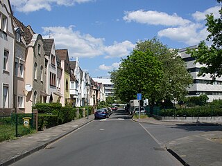
Holthausen is an urban borough of Düsseldorf. It is located south of Oberbilk, west of Reisholz, north of Benrath and east of Itter and Himmelgeist. A natural border is the river Rhine.

Grodowiec is a village in the administrative district of Gmina Grębocice, within Polkowice County, Lower Silesian Voivodeship, in south-western Poland.
Trzcinica Wołowska is a village in the administrative district of Gmina Wińsko, within Wołów County, Lower Silesian Voivodeship, in south-western Poland. Prior to 1945 it was in Germany.

Gyuzeychirkin is a village in the Kalbajar Rayon of Azerbaijan.
Kövdadıq is a village in the Tartar Rayon of Azerbaijan. The village forms part of the municipality of Rəcəbli.
Łąki is a village in the administrative district of Gmina Wąwolnica, within Puławy County, Lublin Voivodeship, in eastern Poland.
Wiązowiec is a village in the administrative district of Gmina Urszulin, within Włodawa County, Lublin Voivodeship, in eastern Poland. It lies approximately 31 kilometres (19 mi) south-west of Włodawa and 46 km (29 mi) north-east of the regional capital Lublin.

The Fushui River (富水) is a river flowing through Tongshan and Yangxin Counties in the south-eastern part of Hubei province, People's Republic of China.
Kisielany-Żmichy is a village in the administrative district of Gmina Mokobody, within Siedlce County, Masovian Voivodeship, in east-central Poland.
Czarnolas-Kolonia is a village in the administrative district of Gmina Policzna, within Zwoleń County, Masovian Voivodeship, in east-central Poland. It lies approximately 12 kilometres (7 mi) north-east of Zwoleń and 99 km (62 mi) south-east of Warsaw.
Ningshan County is a county in the south of Shaanxi province, China. It is the northernmost county-level division of Ankang City.
Piotrówka is a village in the administrative district of Gmina Trzcinica, within Kępno County, Greater Poland Voivodeship, in west-central Poland. It lies approximately 13 kilometres (8 mi) south of Kępno and 154 km (96 mi) south-east of the regional capital Poznań.
Kozie Laski is a village in the administrative district of Gmina Nowy Tomyśl, within Nowy Tomyśl County, Greater Poland Voivodeship, in west-central Poland. It lies approximately 6 kilometres (4 mi) north-east of Nowy Tomyśl and 51 km (32 mi) west of the regional capital Poznań.
Nowy Kraków is a village in the administrative district of Gmina Wronki, within Szamotuły County, Greater Poland Voivodeship, in west-central Poland.
Kaźmierki is a village in the administrative district of Gmina Krzykosy, within Środa Wielkopolska County, Greater Poland Voivodeship, in west-central Poland. It lies approximately 10 kilometres (6 mi) north-west of Krzykosy, 7 km (4 mi) south of Środa Wielkopolska, and 36 km (22 mi) south-east of the regional capital Poznań.
Piaszczyna is a village in Gmina Miastko, Bytów County, Pomeranian Voivodeship, in northern Poland. It lies approximately 16 kilometres (10 mi) south-west of Bytów and 63 km (39 mi) south-west of Gdańsk.
Nowoszów is an abandoned Market town in the administrative district of Gmina Iłowa, within Żagań County, Lubusz Voivodeship, in western Poland. It lies approximately 9 kilometres (6 mi) south-east of Iłowa, 20 km (12 mi) south of Żagań, and 58 km (36 mi) south of Zielona Góra.
Warzeńska Huta is a village in the administrative district of Gmina Przodkowo, within Kartuzy County, Pomeranian Voivodeship, in northern Poland. It lies approximately 8 kilometres (5 mi) north of Przodkowo, 15 km (9 mi) north-east of Kartuzy, and 22 km (14 mi) west of the regional capital Gdańsk.

Stanjinac is a village in the municipality of Knjaževac, Serbia. According to the 2002 census, the village has a population of 95 people.
Palase is a village in Märjamaa Parish, Rapla County in western Estonia.


