
The Groeningemuseum is a municipal museum in Bruges, Belgium, built on the site of the medieval Eekhout Abbey.
Eulate is a town and municipality located in the province and autonomous community of Navarre, northern Spain.
Sedir Island, also known as Cleopatra Island, is a small island in the Gulf of Gökova of southeastern Aegean Sea off the coast of Ula, part of Muğla Province of Turkey. It is famous for its beach made from seashells. It is said that this organic sand was brought by ships from the Red Sea especially for Cleopatra. Each grain of sand is a perfect sphere, for this reason the beach is heavily protected by the government to prevent any sand being removed from the beach. According to legend, Anthony and Cleopatra swam here and the sands were brought by ships from North Africa. It has been said that this type of sand can only be found in Egypt.

Zovk, is a village in the Kotayk Province of Armenia.

Antoniówka is a village in the administrative district of Gmina Kleszczów, within Bełchatów County, Łódź Voivodeship, in central Poland. It lies approximately 4 kilometres (2 mi) west of Kleszczów, 20 km (12 mi) south-west of Bełchatów, and 66 km (41 mi) south of the regional capital Łódź.

Gyulamli is a village in the Davachi Rayon of Azerbaijan.
Alırzalar is a village in the Kalbajar Rayon of Azerbaijan.
Brudzewice-Kolonia is a village in the administrative district of Gmina Poświętne, within Opoczno County, Łódź Voivodeship, in central Poland. It lies approximately 4 kilometres (2 mi) east of Poświętne, 20 km (12 mi) north-east of Opoczno, and 71 km (44 mi) south-east of the regional capital Łódź.
Huta is a village in the administrative district of Gmina Baranów, within Puławy County, Lublin Voivodeship, in eastern Poland.
Piasek is a village in the administrative district of Gmina Stąporków, within Końskie County, Świętokrzyskie Voivodeship, in south-central Poland. It lies approximately 7 kilometres (4 mi) north of Stąporków, 9 km (6 mi) east of Końskie, and 37 km (23 mi) north of the regional capital Kielce.
Kobierno is a village in the administrative district of Gmina Opatówek, within Kalisz County, Greater Poland Voivodeship, in west-central Poland.
Konstantynowo is a village in the administrative district of Gmina Ślesin, within Konin County, Greater Poland Voivodeship, in west-central Poland. It lies approximately 6 kilometres (4 mi) north of Ślesin, 22 km (14 mi) north of Konin, and 96 km (60 mi) east of the regional capital Poznań.
Aleksandrów is a village in the administrative district of Gmina Nowe Miasto nad Wartą, within Środa Wielkopolska County, Greater Poland Voivodeship, in west-central Poland. It lies approximately 21 kilometres (13 mi) south-east of Środa Wielkopolska and 51 km (32 mi) south-east of the regional capital Poznań.
Nowa Wieś Oleska is a village in the administrative district of Gmina Gorzów Śląski, within Olesno County, Opole Voivodeship, in south-western Poland. It lies approximately 3 kilometres (2 mi) north-west of Gorzów Śląski, 20 km (12 mi) north of Olesno, and 55 km (34 mi) north-east of the regional capital Opole.
Kamionki is a settlement in the administrative district of Gmina Nowa Karczma, within Kościerzyna County, Pomeranian Voivodeship, in northern Poland. It lies approximately 4 kilometres (2 mi) north of Nowa Karczma, 16 km (10 mi) east of Kościerzyna, and 36 km (22 mi) south-west of the regional capital Gdańsk.
Silginy is a village in the administrative district of Gmina Barciany, within Kętrzyn County, Warmian-Masurian Voivodeship, in northern Poland, close to the border with the Kaliningrad Oblast of Russia. It lies approximately 11 kilometres (7 mi) north-west of Barciany, 23 km (14 mi) north-west of Kętrzyn, and 71 km (44 mi) north-east of the regional capital Olsztyn.
Lubiechów Dolny is a village in the administrative district of Gmina Cedynia, within Gryfino County, West Pomeranian Voivodeship, in north-western Poland, close to the German border. It lies approximately 4 kilometres (2 mi) north of Cedynia, 42 km (26 mi) south-west of Gryfino, and 62 km (39 mi) south-west of the regional capital Szczecin.
Theater in Cronenberg is a theatre in Wuppertal, North Rhine-Westphalia, Germany.
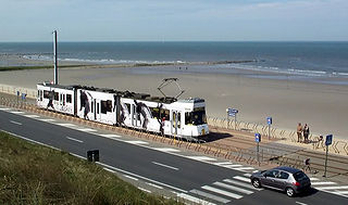
Raversijde is in Flanders a village that's a parish of Ostend and adjacent to Middelkerke which is located on the North Sea coast. Raversijde is located on the Kusttram, which is the coastal tramway.

The Île Rousseau is an island and park in Geneva, situated in the middle of the Rhone. It was named after the philosopher Jean-Jacques Rousseau. On the island is a statue of Rousseau.


