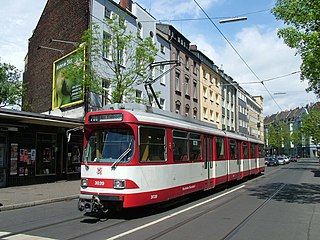
Flingern is a former blue-collar borough of Düsseldorf. Located northeast of Düsseldorf (proper), it is divided into two boroughs today: Flingern-Nord and Flingern-Süd. While Flingern-Nord has a younger population and is more attractive to middle-class families, Flingern-Süd is still mostly home to working-class people.

The Pacific motorcycle Grand Prix was a round of the FIM Grand Prix motorcycle racing championship between 2000 and 2003.

Zagroda is a village in the administrative district of Gmina Chełm, within Chełm County, Lublin Voivodeship, in eastern Poland. It lies approximately 5 kilometres (3 mi) west of Pokrówka, 11 km (7 mi) south-west of Chełm, and 60 km (37 mi) east of the regional capital Lublin.
Kolonia Łopiennik is a village in the administrative district of Gmina Borzechów, within Lublin County, Lublin Voivodeship, in eastern Poland.

Qərvənd is a village in the Fizuli Rayon of Azerbaijan.

Qərchə is a village in the Ismailli Rayon of Azerbaijan.

Koziołek is a village in the administrative district of Gmina Bolesławiec, within Wieruszów County, Łódź Voivodeship, in central Poland. It lies approximately 5 kilometres (3 mi) north-east of Bolesławiec, 11 km (7 mi) south-east of Wieruszów, and 106 km (66 mi) south-west of the regional capital Łódź.

Janusz is a village in the administrative district of Gmina Lututów, within Wieruszów County, Łódź Voivodeship, in central Poland. It lies approximately 3 kilometres (2 mi) north-east of Lututów, 24 km (15 mi) north-east of Wieruszów, and 83 km (52 mi) south-west of the regional capital Łódź.

Rosanów is a village in the administrative district of Gmina Zgierz, within Zgierz County, Łódź Voivodeship, in central Poland. It lies approximately 8 kilometres (5 mi) north of Zgierz and 16 km (10 mi) north of the regional capital Łódź.

Malcanów is a village in the administrative district of Gmina Łuków, within Łuków County, Lublin Voivodeship, in eastern Poland. It lies approximately 5 kilometres (3 mi) south of Łuków and 71 km (44 mi) north of the regional capital Lublin.
Kaleń is a village in the administrative district of Gmina Markuszów, within Puławy County, Lublin Voivodeship, in eastern Poland.

Paruchy is a village in the administrative district of Gmina Końskie, within Końskie County, Świętokrzyskie Voivodeship, in south-central Poland. It lies approximately 10 kilometres (6 mi) east of Końskie and 39 km (24 mi) north of the regional capital Kielce.

Węchadłów is a village in the administrative district of Gmina Michałów, within Pińczów County, Świętokrzyskie Voivodeship, in south-central Poland. It lies approximately 8 kilometres (5 mi) south-west of Michałów, 14 km (9 mi) south-west of Pińczów, and 51 km (32 mi) south of the regional capital Kielce.

Siu Lun is an MTR Light Rail stop located at ground level at Tuen Mun Heung Sze Wui Road between Siu Lun Court and Tsui Ning Garden in Tuen Mun District. It began service on 17 November 1991 and belongs to Zone 1.

Poświątno is a village in the administrative district of Gmina Dominowo, within Środa Wielkopolska County, Greater Poland Voivodeship, in west-central Poland. It lies approximately 4 kilometres (2 mi) north-east of Dominowo, 11 km (7 mi) north-east of Środa Wielkopolska, and 34 km (21 mi) east of the regional capital Poznań.
This is a list of the extreme points of Colombia, the points that are farther north, south, east or west than any other location.
Scarlets Mill is an unincorporated community in Robeson Township, Berks County, Pennsylvania. The Twin Valley School District serves the village, whose zip code is 19508. Scarlets Mill is also located up Haycreek Road from the nearby village of Geigertown.
The Bilstein is a hill in the county of Schwalm-Eder-Kreis, Hesse, Germany. It lies within the Langenberge range.
The Al Tawheed Mosque is a mosque in Sana'a, Yemen. It lies in the eastern part of the city, southeast of Revolution Hospital and Alemaan Mosque, along the E Ring Road.


