
Milików is a village in the administrative district of Gmina Nowogrodziec, within Bolesławiec County, Lower Silesian Voivodeship, in south-western Poland.
Dąbrowa is a village in the administrative district of Gmina Twardogóra, within Oleśnica County, Lower Silesian Voivodeship, in south-western Poland. Prior to 1945 it was in Germany.
Dobryłówka is a village in the administrative district of Gmina Dorohusk, within Chełm County, Lublin Voivodeship, in eastern Poland, close to the border with Ukraine.
Kamionka is a village in the administrative district of Gmina Siedliszcze, within Chełm County, Lublin Voivodeship, in eastern Poland.
Łoje-Gręzko is a village in the administrative district of Gmina Radziłów, within Grajewo County, Podlaskie Voivodeship, in north-eastern Poland.
Borzymy is a village in the administrative district of Gmina Grabowo, within Kolno County, Podlaskie Voivodeship, in north-eastern Poland. It lies approximately 18 kilometres (11 mi) east of Kolno and 76 km (47 mi) north-west of the regional capital Białystok.
Radawczyk Drugi is a village in the administrative district of Gmina Konopnica, within Lublin County, Lublin Voivodeship, in eastern Poland.

Sultan is a village in the Lachin Rayon of Azerbaijan.
Nowy Świat is a village in the administrative district of Gmina Wieluń, within Wieluń County, Łódź Voivodeship, in central Poland. It lies approximately 5 kilometres (3 mi) south of Wieluń and 90 km (56 mi) south-west of the regional capital Łódź.
Krzyworzeka is a village in the administrative district of Gmina Mokrsko, within Wieluń County, Łódź Voivodeship, in central Poland. It lies approximately 6 kilometres (4 mi) south-west of Wieluń and 94 km (58 mi) south-west of the regional capital Łódź.
Żurawiec is a village in the administrative district of Gmina Adamów, within Łuków County, Lublin Voivodeship, in eastern Poland. It lies approximately 9 kilometres (6 mi) south-west of Adamów, 30 km (19 mi) south-west of Łuków, and 56 km (35 mi) north-west of the regional capital Lublin.
Henrysin is a village in the administrative district of Gmina Kosów Lacki, within Sokołów County, Masovian Voivodeship, in east-central Poland.
Kupientyn-Kolonia is a village in the administrative district of Gmina Sabnie, within Sokołów County, Masovian Voivodeship, in east-central Poland.
Różyczka is a village in the administrative district of Gmina Trzcinica, within Kępno County, Greater Poland Voivodeship, in west-central Poland.
Myje is a village in the administrative district of Gmina Ostrzeszów, within Ostrzeszów County, Greater Poland Voivodeship, in west-central Poland. It lies approximately 8 kilometres (5 mi) north-west of Ostrzeszów and 127 km (79 mi) south-east of the regional capital Poznań.
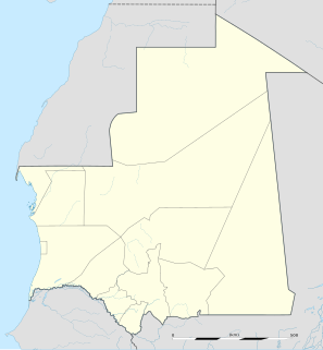
Aioun or El Aioun is a town and commune in the Assaba Region of southern Mauritania near the border with Mali. It has a population of 22,796.

Nachtegalen Park is a park located in the Antwerp, Belgium municipality of Wilrijk. It served as the archery venue for the 1920 Summer Olympics.
Goris Airport, also known as Shinuyar Airport or Shinuhayr Airport is located to the south of Goris, near the village of Shinuhayr, Syunik Province, Armenia. It has been closed since the collapse of the USSR in 1991. However, the Armenian government plans on reconstructing the airport and opening it to public and private service by 2019.
The Knole Academy is a secondary school in Sevenoaks, Kent, England that was opened in September 2010, as a result of the amalgamation of the Wildernesse School and Bradbourne School. The two sites for each of the previous schools was used for the construction of the new Academy buildings which were completed in 2015. When the two schools merged not all of the students from Wildernesse moved over, the merging of all students was only completed in September 2011. Since then the site at Knole East has been used the construction of Trinity School, Sevenoaks and Weald of Kent Grammar School.

Berceni Stadium is a football stadium in Berceni, Romania. The stadium holds 2,700 people.


