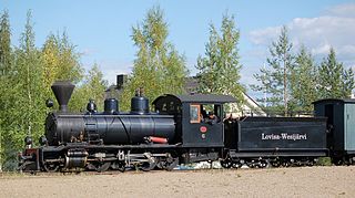
The Jokioinen Museum Railway is located in Jokioinen, Finland. It is located on the last operating commercial narrow gauge railway in Finland, the 750 mm gauge Jokioinen Railway.

Sõrve Peninsula is a peninsula which forms the southernmost section of the Estonian island Saaremaa. Its length is 32 km, and its maximum width 10 km. South of it lies Irbe Strait, the main entrance to the Gulf of Riga of the Baltic Sea.

Wabienice is a village in the administrative district of Gmina Bierutów, within Oleśnica County, Lower Silesian Voivodeship, in south-western Poland. Prior to 1945 it was in Germany.

Krzelów is a village in the administrative district of Gmina Wińsko, within Wołów County, Lower Silesian Voivodeship, in south-western Poland. Prior to 1945 it was in Germany. It lies approximately 10 kilometres (6 mi) west of Wińsko, 14 km (9 mi) north-west of Wołów, and 51 km (32 mi) north-west of the regional capital Wrocław.
Gotówka is a village in the administrative district of Gmina Ruda-Huta, within Chełm County, Lublin Voivodeship, in eastern Poland, close to the border with Ukraine.
Downary is a village in the administrative district of Gmina Goniądz, within Mońki County, Podlaskie Voivodeship, in north-eastern Poland. It lies approximately 6 kilometres (4 mi) south-west of Goniądz, 9 km (6 mi) north-west of Mońki, and 49 km (30 mi) north-west of the regional capital Białystok.

Danayeri is a village in the Goygol Rayon of Azerbaijan. The village forms part of the municipality of Qızılca.
Krosno-Bugaj is a settlement in the administrative district of Gmina Gorzkowice, within Piotrków County, Łódź Voivodeship, in central Poland.
Gowarczów is a village in Końskie County, Świętokrzyskie Voivodeship, in south-central Poland. It is the seat of the gmina called Gmina Gowarczów. It lies in historic Lesser Poland, approximately 9 kilometres (6 mi) north of Końskie and 46 km (29 mi) north of the regional capital Kielce. The village has a population of 1,400.
Koliszowy is a village in the administrative district of Gmina Ruda Maleniecka, within Końskie County, Świętokrzyskie Voivodeship, in south-central Poland. It lies approximately 4 kilometres (2 mi) north of Ruda Maleniecka, 14 km (9 mi) west of Końskie, and 43 km (27 mi) north-west of the regional capital Kielce.
Zdunówek is a village in the administrative district of Gmina Raciąż, within Płońsk County, Masovian Voivodeship, in east-central Poland.
Stary Młyn is a settlement in the administrative district of Gmina Przytyk, within Radom County, Masovian Voivodeship, in east-central Poland.
Zakrzew-Las is a village in the administrative district of Gmina Zakrzew, within Radom County, Masovian Voivodeship, in east-central Poland.
The Rural Municipality of Gilbert Plains is a former rural municipality (RM) in the Canadian province of Manitoba. It was originally incorporated as a rural municipality on March 30, 1897. It ceased on January 1, 2015 as a result of its provincially mandated amalgamation with the Town of Gilbert Plains to form the Gilbert Plains Municipality.
Cebalet, formerly named Cebbala Ouled Asker, is a town and commune in the Sidi Bou Zid Governorate, Tunisia. As of 2004 it had a population of 2,506.
Soosalu is a village in Järva Parish, Järva County in northern-central Estonia.
Lehtisaari is an island and part of Munkkiniemi, a neighborhood in western Helsinki, Finland.

Opetci is a village in the municipality of Srebrenica, Bosnia and Herzegovina.
Gangavalli is a state assembly constituency in Tamil Nadu, India, that was formed after constituency delimitations in 2007. Located in Salem district, it comprises Gangavalli taluk and a portion of Attur taluk. It is a part of the Kallakurichi constituency for national elections to the Parliament of India. The seat is reserved for candidates from the Scheduled Castes.

Largo do Machado is a square located on the border of the Catete, Flamengo and Laranjeiras neighborhoods in the city of Rio de Janeiro, Brazil.


