Gmina Uścimów is a rural gmina in Lubartów County, Lublin Voivodeship, in eastern Poland. Its seat is the village of Uścimów, which lies approximately 24 kilometres (15 mi) east of Lubartów and 36 km (22 mi) north-east of the regional capital Lublin.
Gmina Zalesie is a rural gmina in Biała Podlaska County, Lublin Voivodeship, in eastern Poland. Its seat is the village of Zalesie, which lies approximately 18 kilometres (11 mi) east of Biała Podlaska and 104 km (65 mi) north-east of the regional capital Lublin.
Gmina Milejów is a rural gmina in Łęczna County, Lublin Voivodeship, in eastern Poland. Its seat is the village of Milejów-Osada, which lies approximately 10 kilometres (6 mi) south of Łęczna and 26 km (16 mi) east of the regional capital Lublin.
Gmina Trzebieszów is a rural gmina in Łuków County, Lublin Voivodeship, in eastern Poland. Its seat is the village of Trzebieszów, which lies approximately 14 kilometres (9 mi) north-east of Łuków and 82 km (51 mi) north of the regional capital Lublin.
Gmina Janowiec is a rural gmina in Puławy County, Lublin Voivodeship, in eastern Poland. Its seat is the village of Janowiec, which lies approximately 12 kilometres (7 mi) south-west of Puławy and 49 km (30 mi) west of the regional capital Lublin.
Gmina Kazimierz Dolny is an urban-rural gmina in Puławy County, Lublin Voivodeship, in eastern Poland. Its seat is the town of Kazimierz Dolny, which lies approximately 11 kilometres (7 mi) south of Puławy and 45 km (28 mi) west of the regional capital Lublin.
Gmina Nałęczów is an urban-rural gmina in Puławy County, Lublin Voivodeship, in eastern Poland. Its seat is the town of Nałęczów, which lies approximately 23 kilometres (14 mi) south-east of Puławy and 25 km (16 mi) west of the regional capital Lublin.
Gmina Wąwolnica is a rural gmina in Puławy County, Lublin Voivodeship, in eastern Poland. Its seat is the village of Wąwolnica, which lies approximately 19 kilometres (12 mi) south-east of Puławy and 31 km (19 mi) west of the regional capital Lublin.
Gmina Żyrzyn is a rural gmina in Puławy County, Lublin Voivodeship, in eastern Poland. Its seat is the village of Żyrzyn, which lies approximately 14 kilometres (9 mi) north-east of Puławy and 44 km (27 mi) north-west of the regional capital Lublin.
Gmina Wyryki is a rural gmina in Włodawa County, Lublin Voivodeship, in eastern Poland. Its seat is the village of Wyryki, which lies approximately 12 kilometres (7 mi) west of Włodawa and 67 km (42 mi) north-east of the regional capital Lublin.
Gmina Nielisz is a rural gmina in Zamość County, Lublin Voivodeship, in eastern Poland. Its seat is the village of Nielisz, which lies approximately 18 kilometres (11 mi) north-west of Zamość and 60 km (37 mi) south-east of the regional capital Lublin.
Gmina Szydłowo is a rural gmina in Piła County, Greater Poland Voivodeship, in west-central Poland. Its seat is the village of Szydłowo, which lies approximately 8 kilometres (5 mi) west of Piła and 87 km (54 mi) north of the regional capital Poznań.

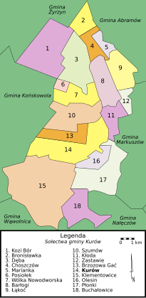
Klementowice is a village in the administrative district of Gmina Kurów, within Puławy County, Lublin Voivodeship, in eastern Poland. It lies approximately 7 kilometres (4 mi) south-west of Kurów, 15 km (9 mi) south-east of Puławy, and 32 km (20 mi) west of the regional capital Lublin.
Kolonia Klementowice is a village in the administrative district of Gmina Kurów, within Puławy County, Lublin Voivodeship, in eastern Poland. It lies approximately 4 kilometres (2 mi) south-west of Kurów, 13 km (8 mi) east of Puławy, and 34 km (21 mi) north-west of the regional capital Lublin.
Kolonia Płonki is a village in the administrative district of Gmina Kurów, within Puławy County, Lublin Voivodeship, in eastern Poland.
Mała Dęba is a village in the administrative district of Gmina Kurów, within Puławy County, Lublin Voivodeship, in eastern Poland.
Mała Kłoda is a village in the administrative district of Gmina Kurów, within Puławy County, Lublin Voivodeship, in eastern Poland.
Płonki is a village in the administrative district of Gmina Kurów, within Puławy County, Lublin Voivodeship, in eastern Poland. It lies approximately 3 kilometres (2 mi) south-east of Kurów, 17 km (11 mi) east of Puławy, and 30 km (19 mi) north-west of the regional capital Lublin.