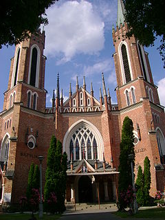
Parczew is a town in eastern Poland, with a population of 10,281 (2006). Situated in the Lublin Voivodeship, previously in Biała Podlaska Voivodeship (1975–1998). It is the capital of Parczew County.

Opole Lubelskie is a town in eastern Poland. As of 2004, it had 8,879 inhabitants. The town is situated in Lublin Voivodeship, some 10 kilometers east of the Vistula River, and is the capital of Opole Lubelskie County. It was founded in the 14th century, and historically belongs to Lublin Land, which is part of Lesser Poland.

Szamotuły is a town in Poland, in Greater Poland Voivodeship, about 35 kilometres northwest of the centre of Poznań. It is the seat of Szamotuły County and of the smaller administrative district Gmina Szamotuły. The population was 19,090 in 2011.

Kimmerikón was an ancient Greek city in Crimea, on the southern shore of the Kerch Peninsula, at the western slope of Mount Opuk, roughly 40 kilometres southwest of modern Kerch. It was situated with its acropolis on the hills on the west side of the mountain. The town was founded by the Milesian colonists in the 5th century BC and flourished at the beginning of the Christian era. Its name may refer to an earlier Cimmerian settlement on the site.

Tân Phú is a district (huyện) of Đồng Nai Province in the Southeast region of Vietnam.
92.5 ABC Central Coast is an ABC Local Radio station based in Gosford and broadcasting to the Central Coast region in New South Wales. The transmission area of the station stretches from Woy Woy to The Entrance. The signal is notoriously weak in many valley areas of the region.

Thwaite St Mary is a rural hamlet in the English county of Norfolk, it sits just a few miles north of the Suffolk border. Thwaite – sometimes pronounced ‘twayt’ by locals – has approximately thirty-five dwellings and a population of around seventy-nine. The population is included in the civil parish of Hedenham.
Łuh is a village in the administrative district of Gmina Cisna, within Lesko County, Subcarpathian Voivodeship, in south-eastern Poland, close to the border with Slovakia.

Głogówko is a settlement in the administrative district of Gmina Piaski, within Gostyń County, Greater Poland Voivodeship, in west-central Poland. It lies approximately 3 kilometres (2 mi) west of Piaski, 2 km (1 mi) north-east of Gostyń, and 58 km (36 mi) south of the regional capital Poznań.

Phong Hóa is a commune (xã) and village in Tuyên Hóa District, Quảng Bình Province, in Vietnam.

Kurgan State University is a university in Kurgan, Kurgan Oblast of Russia. It was established in 1951 in accordance with presidential decree by the merger of engineering and public teaching institutions. University prepares specialists humanitarian, socio-economic and technical specialties.

The Funbo Church is a medieval church in Funbo village, Uppsala Municipality in Uppsala County Sweden. It is located in the parish of Danmark-Funbo, in the Archdiocese of Uppsala.

The equestrian statue of Charles I at Charing Cross, London, is a work by the French sculptor Hubert Le Sueur, probably cast in 1633.

Khandpara State was one of the princely states of India during the period of the British Raj. It was located in present-day Nayagarh district, Odisha.

Gessate is a suburban station on Line 2 of the Milan Metro in the town of the same name.
Palilula is a village in Boychinovtsi Municipality, Montana Province, north-western Bulgaria.
Kniset Nakhleh is a Syrian village located in Jisr al-Shughur Nahiyah in Jisr al-Shughur District, Idlib. According to the Syria Central Bureau of Statistics (CBS), Kniset Nakhleh had a population of 1675 in the 2004 census.
The Armenian Catholic Archeparchy of Lviv is a former, non-Metropolitan archeparchy of the Armenian Catholic Church sui iuris. It existed in 1630 to 1944.

The Museum of Natural and Environmental History,Shizuoka is a prefectural museum in Shizuoka City, Japan.

Krishnanagar is a village in Chanditala I community development block of Srirampore subdivision in Hooghly district in the Indian state of West Bengal.


