Deer's Mill, Indiana

Last updated
Deer's Mill, Indiana
Deers-mill-bridge2.jpg
Deer's Mill Covered Bridge
Location map of Montgomery County, Indiana.svg
Red pog.svg
Deer's Mill
Location in Montgomery County
Coordinates: 39°56′46″N87°03′33″W / 39.94611°N 87.05917°W / 39.94611; -87.05917 Coordinates: 39°56′46″N87°03′33″W / 39.94611°N 87.05917°W / 39.94611; -87.05917
Country United States
State Indiana
County Montgomery
Township Ripley
Elevation
[1]
591 ft (180 m)
Time zone UTC-5 (Eastern (EST))
  Summer (DST) UTC-4 (EDT)
ZIP code
47933
Area code 765
FIPS code 18-17336 [2]
GNIS feature ID 433435

Deer's Mill is an unincorporated community in Ripley Township, Montgomery County, in the U.S. state of Indiana. [3]

Contents

History

Deer's Mill was built by Joel Deer in 1829.

A year after arriving in Montgomery County, in 1829, Joel built the township's first grist and saw mill along the banks of Sugar Creek. [4] It was called Deer's Mill, and that small corner of Montgomery County retains that name to this day. The original millhouse was of log construction with common stones, and primarily ground wheat and corn.

In 1833, Joel platted a small village adjacent to the mill. It was at various times known as Deer's Mill, Deerfield, Deerford, and Bluff Mill. The community, however, never quite developed, and any remnants have long since vanished. Deer's Mill, however, did a thriving business, and in 1839, Joel replaced the original log structure with one made of frame construction. Over time, a woolen mill and general store were added to the Deer's Mill enterprise. [5]

Bridge

The Deer's Mill bridge was built in 1878 by J. J. Daniels and spans 275 feet (84 m) across Sugar Creek. [5] It was documented by the Historic American Engineering Record in 1974. [6]

Deer's Mill Covered Bridge Deers-mill-bridge.jpg
Deer's Mill Covered Bridge

Geography

Deer's Mill is located at 39°56′46″N87°03′33″W / 39.94611°N 87.05917°W / 39.94611; -87.05917 .

Related Research Articles

<span class="mw-page-title-main">Montgomery County, Indiana</span> County in Indiana, United States

Montgomery County is a county in the U.S. state of Indiana. As of the 2020 United States census, it had a population of 37,936. Its county seat is Crawfordsville. The county is divided into eleven townships which provide local services.

<span class="mw-page-title-main">Alamo, Indiana</span> Town in Indiana, United States

Alamo is a town in Ripley Township, Montgomery County, in the U.S. state of Indiana. The population was 66 at the 2010 census.

<span class="mw-page-title-main">Adams Township, Parke County, Indiana</span> Township in Indiana, United States

Adams Township is one of thirteen townships in Parke County, Indiana, United States. As of the 2010 census, its population was 5,825 and it contained 2,062 housing units.

<span class="mw-page-title-main">Pennypack Creek</span>

Pennypack Creek is a 22.6-mile-long (36.4 km) creek in southeastern Pennsylvania in the United States. It runs southeast through lower Bucks County, eastern Montgomery County and the northeast section of Philadelphia, before emptying into the Delaware River.

<span class="mw-page-title-main">Deer Creek (Maryland)</span> River

Deer Creek is a 52.9-mile-long (85.1 km) river in Maryland and Pennsylvania that flows through the scenic areas of Harford County and empties into the Susquehanna River, roughly halfway between the Interstate 95 bridge and Conowingo Dam. Its watershed area is 171 square miles (440 km2). Its watershed area in MD is 145 square miles (380 km2), with 3% impervious surface in 1994. It serves as a divider between the agricultural and urban/suburban areas of Harford County.

<span class="mw-page-title-main">Beeson Covered Bridge</span> Bridge in Parke County, Indiana

The Beeson Covered Bridge originally crossed Roaring Creek, one mile (1.6 km) northwest of Marshall, Indiana, on County Road 216, in Washington Township, Parke County. The bridge was moved to its current location in Billie Creek Village in December 1979.

<span class="mw-page-title-main">Portland Mills Covered Bridge</span> Bridge in Indiana, United States

The Portland Mills Covered Bridge is the second oldest covered bridge in Parke County, Indiana, being built the same year as the Crooks Covered Bridge. It is a single span Burr Arch Truss covered bridge that was built by Henry Wolf in 1856.

<span class="mw-page-title-main">Lodi, Indiana</span> Unincorporated community in Indiana, United States

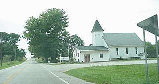
Lodi is an unincorporated community in Liberty Township, Parke County, Indiana. Located on Indiana State Road 234, the most prominent feature is Waterman Baptist Church, which occupies a red brick building in the north-east corner of town. Just south of the town is one of the first round barns, the W. H. York Round Barn, which was built in 1895.

<span class="mw-page-title-main">Jackson Township, Parke County, Indiana</span> Township in Indiana, United States

Jackson Township is one of thirteen townships in Parke County, Indiana, United States. As of the 2010 census, its population was 737 and it contained 475 housing units.

<span class="mw-page-title-main">Liberty Township, Parke County, Indiana</span> Township in Indiana, United States

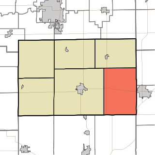
Liberty Township is one of thirteen townships in Parke County, Indiana, United States. As of the 2010 census, its population was 739 and it contained 324 housing units.

<span class="mw-page-title-main">Raccoon Township, Parke County, Indiana</span> Township in Indiana, United States

Raccoon Township is one of thirteen townships in Parke County, Indiana, United States. At the 2010 census, its population was 659 and it had 345 housing units.

<span class="mw-page-title-main">Sugar Creek Township, Parke County, Indiana</span> Township in Indiana, United States

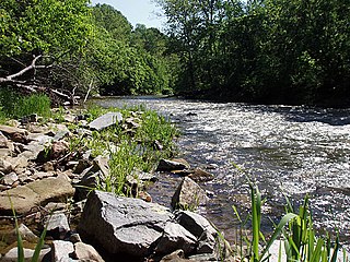
Sugar Creek Township is one of thirteen townships in Parke County, Indiana, United States. As of the 2010 census, its population was 322 and it contained 154 housing units. The township includes the north half of Turkey Run State Park.

<span class="mw-page-title-main">Madison Township, Tipton County, Indiana</span> Township in Indiana, United States

Madison Township is one of six townships in Tipton County, Indiana, United States. As of the 2010 census, its population was 1,396 and it contained 596 housing units.

<span class="mw-page-title-main">Coal Creek Township, Montgomery County, Indiana</span> Township in Indiana, United States

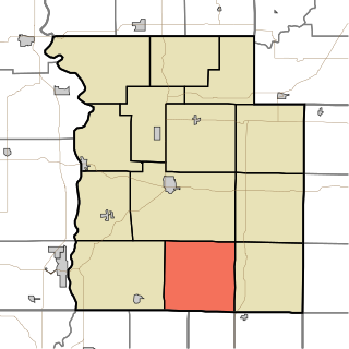
Coal Creek Township is one of eleven townships in Montgomery County, Indiana, United States. As of the 2010 census, its population was 1,544 and it contained 655 housing units.

<span class="mw-page-title-main">Ripley Township, Montgomery County, Indiana</span> Township in Indiana, United States

Ripley Township is one of eleven townships in Montgomery County, Indiana, United States. As of the 2010 census, its population was 977 and it contained 456 housing units.

<span class="mw-page-title-main">Sugar Creek Township, Montgomery County, Indiana</span> Township in Indiana, United States

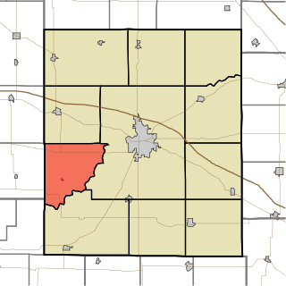
Sugar Creek Township is one of eleven townships in Montgomery County, Indiana, United States. As of the 2010 census, its population was 448 and it contained 167 housing units.

<span class="mw-page-title-main">Union Mills, Indiana</span> Unincorporated community in Indiana, United States

Union Mills is an unincorporated community in Noble Township, LaPorte County, Indiana.

<span class="mw-page-title-main">Yountsville, Indiana</span> Unincorporated community in Indiana, United States

Yountsville is an unincorporated community in Ripley Township, Montgomery County, in the U.S. state of Indiana.

<span class="mw-page-title-main">Crooked Creek (Allegheny River tributary)</span> River in the United States

Crooked Creek is a tributary of the Allegheny River in both Armstrong and Indiana counties in the U.S. state of Pennsylvania.

<span class="mw-page-title-main">Lusks Mills, Indiana</span> Unincorporated community in Indiana, United States

Lusks Mills is an unincorporated community in Sugar Creek Township, Parke County, in the U.S. state of Indiana.

References

  1. "US Board on Geographic Names". United States Geological Survey. October 25, 2007. Retrieved 2017-05-09.
  2. "U.S. Census website". United States Census Bureau . Retrieved 2008-01-31.
  3. "Deer's Mill, Indiana". Geographic Names Information System . United States Geological Survey . Retrieved July 17, 2017.
  4. Beckwith, Hiram Williams; Kennedy, P. S. (1881). History of Montgomery County, Together with Historic Notes on the Wabash Valley. H. H. Hill and N. Iddings. p.  350.
  5. 1 2 Montgomery County, Indiana USGenWeb Project
  6. Historic American Engineering Record (HAER) No. IN-28, " Deer's Mill Covered Bridge, Spanning Sugar Creek at Highway 234, Alamo, Montgomery County, IN "