
Norman Clyde was a mountaineer, mountain guide, freelance writer, nature photographer, and self-trained naturalist. He is well known for achieving over 130 first ascents, many in California's Sierra Nevada and Montana's Glacier National Park. He also set a speed climbing record on California's Mount Shasta in 1923. The Bancroft Library at the University of California, Berkeley has 1467 articles written by Clyde in its archives.

North Palisade is the third-highest mountain in the Sierra Nevada range of California, and one of the state's small number of peaks over 14,000 feet, known as fourteeners. It is the highest peak of the Palisades group of peaks in the central part of the Sierra range. It sports a small glacier and several highly prized rock climbing routes on its northeast side.

Jules Marquard Eichorn was an American mountaineer, environmentalist, and music teacher.

Glen Dawson was an American rock climber, mountaineer, antiquarian bookseller, publisher and environmentalist.

Robert K. Brinton was a pioneer American rock climber and ski mountaineer. Along with his frequent climbing partner, Glen Dawson, he made numerous first ascents in California, British Columbia, and Utah in the 1930s and named a number of well-known routes.
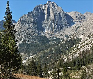
The Citadel is an 11,738-foot-elevation (3,578-meter) mountain summit located in the Sierra Nevada mountain range, in Fresno County of central California, United States. It is situated in northern Kings Canyon National Park, 20 miles (32 km) west-southwest of the community of Big Pine, and 2.4 miles (3.9 km) south of Langille Peak. Topographic relief is significant as it rises 3,400 feet above Le Conte Canyon in approximately one mile. The long approach to this remote peak is made via the John Muir Trail. The Northeast Arête, also known as Edge of Time Arête, is considered one of the classic climbing routes in the Sierra Nevada.

Recess Peak is a 12,813-foot-elevation mountain summit located west of the crest of the Sierra Nevada mountain range in Fresno County of northern California, United States. It is situated on Mono Divide in the John Muir Wilderness, on land managed by Sierra National Forest, and approximately six miles east of Lake Thomas A Edison. The nearest higher neighbor is Mount Hilgard, 2.2 miles (3.5 km) to the southeast. The John Muir Trail follows Bear Creek below the western slope of this remote peak. The summit is surrounded by arêtes and cirques, which were formed by glaciers in the past, most recently ending 13,000 years ago in the late Pleistocene.

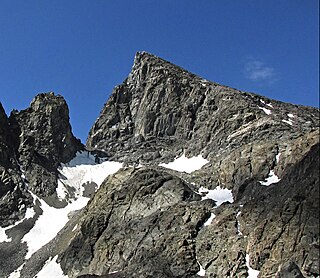
North Guard is a remote 13,327-foot-elevation (4,062-meter) mountain summit located near the northern end of the Great Western Divide of the Sierra Nevada mountain range, in Tulare County of northern California. It is situated in Kings Canyon National Park, 0.9 miles (1.4 km) southeast of Mount Farquhar, and 0.6 miles (0.97 km) north-northwest of Mount Brewer, which is the nearest higher neighbor. Topographic relief is significant as the east aspect rises 3,858 feet above East Lake in three miles. North Guard ranks as the 87th highest summit in California, and the second highest point of the northern Great Western Divide. It's not as high as Mount Brewer, but offers better climbing and is considered one of the classic climbing routes in the Sierra Nevada.
Center Peak is a 12,760-foot-elevation (3,890-meter) mountain summit located one mile west of the crest of the Sierra Nevada mountain range, in the northeast corner of Tulare County in northern California. It is situated in eastern Kings Canyon National Park, 11 miles (18 km) southwest of the community of Independence, 1.8 miles (2.9 km) south of University Peak, and two miles north of Forester Pass. Topographic relief is significant as the north aspect rises 2,230 feet above Bubbs Creek in one mile. The John Muir Trail which traverses below the west slope of this remote peak provides an approach.

Mount McGee is a 12,944-foot-elevation (3,945-meter) mountain summit located west of the crest of the Sierra Nevada mountain range, in Fresno County of central California, United States. It is situated in northern Kings Canyon National Park, 0.6 miles (0.97 km) southeast of Peter Peak, 2 miles (3.2 km) southwest of The Hermit, and 2.6 miles (4.2 km) north-northwest of Mount Goddard, the nearest higher neighbor. Topographic relief is significant as the west aspect rises 3,100 feet above Goddard Canyon in two miles. This geographical feature was named for William John McGee (1853–1912), well-known American geologist and anthropologist. This mountain's name has been officially adopted by the United States Board on Geographic Names. The first ascent of the summit was made in July 1923 by Roger N. Burnham, Robert E. Brownlee, Ralph H. Brandt, and Leonard Keeler.

Mount Genevra is a remote 13,054-foot-elevation (3,979-meter) mountain summit located on the Kings–Kern Divide of the Sierra Nevada mountain range, in Tulare County of northern California. It is situated on the shared boundary of Kings Canyon National Park with Sequoia National Park, 3.5 miles (5.6 km) southeast of Mount Brewer, and 0.86 miles (1.38 km) east of Mount Jordan, which is the nearest higher neighbor. Topographic relief is significant as the north aspect rises 3,025 feet above Lake Reflection in 1.5 mile. Mount Genevra ranks as the 138th highest summit in California, and the eighth highest peak on the Kings–Kern Divide.
South Guard is a remote 13,232-foot-elevation (4,033-meter) mountain summit located near the northern end of the Great Western Divide of the Sierra Nevada mountain range, in Tulare County of northern California. It is situated in Kings Canyon National Park, 1.63 miles (2.62 km) south of North Guard, and one mile south of Mount Brewer, which is the nearest higher neighbor. Topographic relief is significant as the west aspect rises 4,600 feet above Cloud Canyon in 3.5 miles, and the east aspect rises 3,200 feet above Lake Reflection in two miles. South Guard ranks as the 103rd highest summit in California, and the third-highest point of the northern Great Western Divide.

Giraud Peak is a 12,608-foot-elevation (3,843-meter) mountain summit located west of the crest of the Sierra Nevada mountain range, in Fresno County of northern California, United States. It is situated in the Palisades area of northern Kings Canyon National Park, 3.0 miles (4.8 km) southwest of North Palisade, and 1.5 miles (2.4 km) southwest of Columbine Peak, the nearest higher neighbor. Giraud Peak ranks as the 258th-highest summit in California. Topographic relief is significant as the west aspect rises 4,400 feet above LeConte Canyon in less than two miles. On the direct opposite side of the canyon The Citadel stands guard. The first ascent of the summit was made September 1, 1925, by Norman Clyde via the east arête.

The Thumb is a 13,356-foot-elevation (4,071-meter) mountain summit located on the crest of the Sierra Nevada mountain range, in Inyo County of northern California. It is situated in the Palisades area of the John Muir Wilderness, on land managed by Inyo National Forest. It is 1.3 miles (2.1 km) east of Middle Palisade, 1.6 miles (2.6 km) west-northwest of Birch Mountain, and 1.8 miles (2.9 km) north of Mount Bolton Brown. The Thumb ranks as the 83rd-highest summit in California. Topographic relief is significant as the east aspect rises over 2,500 feet above Birch Lake in approximately one mile. The John Muir Trail traverses below the southwest aspect of the mountain, providing an optional approach access.

Wheel Mountain is a 12,774-foot-elevation (3,894-meter) mountain summit located west of the crest of the Sierra Nevada mountain range, in Fresno County of central California, United States. This mountain is situated on the Black Divide in northern Kings Canyon National Park, one mile northwest of Devils Crags, and two miles south-southeast of Mount McDuffie, which is the nearest higher neighbor. Wheel Mountain ranks as the 216th-highest summit in California, and the fifth-highest on Black Divide. Topographic relief is significant as the west aspect rises 4,500 feet above Enchanted Gorge in approximately 1.5 mile, and the east aspect rises 4,500 feet above Le Conte Canyon in 2.5 miles. An approach to this remote peak is made possible via the John Muir Trail.

Mount Johnson is a 12,871-foot-elevation mountain summit located on the crest of the Sierra Nevada mountain range in California, United States. It is situated on the boundary between Kings Canyon National Park and John Muir Wilderness, and along the county line between Fresno County and Inyo County. It is also 18 miles (29 km) west of the community of Big Pine, 0.9 miles (1.4 km) southeast of Mount Gilbert, and one mile (1.6 km) west-northwest of Mount Goode. Mount Johnson ranks as the 187th-highest summit in California. Topographic relief is significant as the southwest aspect rises 3,670 feet above LeConte Canyon in 1.5 mile, and the north aspect rises 3,100 feet above South Lake in 2.5 miles.

Observation Peak is a 12,362-foot-elevation summit located in Fresno County, California, United States.
Muriel Peak is a 12,937-foot-elevation (3,943 meter) double summit mountain located in the Sierra Nevada mountain range in Fresno County, California, United States. The true summit is set within the John Muir Wilderness on land managed by Sierra National Forest, whereas the slightly lower south summit is on the boundary shared with Kings Canyon National Park. It is situated one mile northeast of Mount Goethe and one mile south of Muriel Lake. Muriel Peak is the 167th-highest peak in California, and topographic relief is significant as the summit rises 1,600 feet above Muriel Lake.
Scylla is a 12,956-foot-elevation (3,949 meter) mountain summit located west of the crest of the Sierra Nevada mountain range, in Fresno County, California, United States. This peak is situated in Kings Canyon National Park, 1.27 miles (2.04 km) southwest of Charybdis, 2.3 miles (3.7 km) southeast of Mount Goddard, and 2.57 miles (4.14 km) west of Mount McDuffie. Topographic relief is significant as the summit rises 3,150 feet above Enchanted Gorge in approximately one mile. The John Muir Trail provides one possible approach option to this remote peak. An ascent of the peak is non-technical via the northwest slope, and inclusion on the Sierra Peaks Section peakbagging list generates climbing interest in this peak.

Clyde Spires is a 13,267-foot-elevation (4,044 meter) mountain summit located on the crest of the Sierra Nevada mountain range in California, United States. It is situated on the boundary shared by Kings Canyon National Park with John Muir Wilderness, and along the common border of Fresno County with Inyo County. It is 20 miles (32 km) west of the community of Big Pine, and 0.5 miles (0.80 km) southeast of Mount Wallace, which is the nearest higher neighbor. The west spire is slightly higher than the east spire. Topographic relief is significant as the spires rise 1,665 feet above Echo Lake in 0.38 miles (0.61 km).


