
Black Giant is a 13,330-foot-elevation (4,060-meter) mountain summit located west of the crest of the Sierra Nevada mountain range, in Fresno County of central California, United States. Black Giant ranks as the 86th highest summit in California. It is the northernmost and highest summit on its namesake ridge, the Black Divide in northern Kings Canyon National Park. The peak is situated 3.9 miles (6.3 km) east of Mount Goddard, and 2.6 miles (4.2 km) south-southeast of Mount Fiske, which is the nearest higher neighbor. Topographic relief is significant as it rises 4,000 feet above Le Conte Canyon in approximately two miles. Muir Pass is 1.4 miles (2.3 km) to the northwest, and the approach to this remote peak is made via the John Muir Trail.

Crater Mountain is a 12,874-foot-elevation (3,924-meter) mountain summit located west of the crest of the Sierra Nevada mountain range, in Fresno County of northern California, United States. It is situated in eastern Kings Canyon National Park, 15.5 miles (24.9 km) northwest of the community of Independence, one mile immediately southwest of Pinchot Pass, and 1.3 miles (2.1 km) southeast of Mount Ickes, which is the nearest higher neighbor. Other nearby peaks include Mount Wynne, 1.5 miles (2.4 km) to the northeast, and Mount Cedric Wright, 2.2 miles (3.5 km) to the southeast. Crater Mountain ranks as the 186th highest summit in California. Topographic relief is significant as the west aspect rises 2,000 feet in less than one mile. The approach to this remote peak is made via the John Muir Trail which passes below the east aspect of the mountain. The first ascent of the summit was made July 19, 1922, by W. H. Ink, Meyers Butte, Frank Baxter, and Captain Wallace. This mountain has no crater as the name implies.
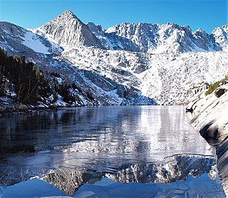
Mount Lamarck is a 13,417-foot-elevation (4,090-meter) mountain summit located on the crest of the Sierra Nevada mountain range in northern California, United States. It is situated on the shared boundary of Kings Canyon National Park with John Muir Wilderness, and along the common border of Fresno County with Inyo County. It is 20 miles (32 km) southwest of the community of Bishop, and 1.9 miles (3.1 km) north of Mount Darwin. Subsidiary peak Mount Lamarck North (13,464 feet ranks as the 67th highest summit in California, and the sixth highest in the Evolution Region. Topographic relief is significant as the east aspect rises 4,290 feet above Lake Sabrina in three miles, and the west aspect rises 3,600 feet above Evolution Valley in three miles.

The Sphinx is a 9,143-foot-elevation (2,787-meter) double summit granitic pillar located west of the crest of the Sierra Nevada mountain range, in Kings Canyon National Park, in Fresno County of northern California. This landmark is situated at the northern end of the Great Western Divide, two miles southeast of Kanawyers, five miles northwest of North Guard, and immediately south of the confluence of Bubbs Creek and South Fork Kings River. Topographic relief is significant as the north aspect rises 4,000 feet above the canyon in one mile. This geographical feature was named in 1891 by John Muir. This feature's name has been officially adopted by the United States Board on Geographic Names. The Sphinx formation is the further north and slightly lower of the two peaks, and was the first rock climb done in the Kings Canyon region. The first ascent of the summit was made July 26, 1940, by Art Argiewicz and Bob Jacobs. The North Buttress was first climbed October 18, 1970, by Fred Beckey, Greg Donaldson, and Walt Vennum.

Whaleback is a remote 11,717-foot-elevation (3,571-meter) three-mile-long ridge located in the Sierra Nevada mountain range, in Tulare County of northern California. It is situated in Kings Canyon National Park, extending north from the Great Western Divide. This geographical feature has significant topographic relief as it rises 2,900 feet above Shortys Cabin in Cloud Canyon in approximately one mile. Whaleback ranks as the 488th highest peak in California. The first ascent of the summit was made August 5, 1936, by May Pridham and Adele van Loben Sels.
Devils Crags is a 12,424-foot-elevation (3,787-meter) mountain summit located west of the crest of the Sierra Nevada mountain range, in Fresno County of central California, United States. This jagged line of 11 pinnacles is situated at the southern end of the Black Divide in northern Kings Canyon National Park, 1.88 miles (3.03 km) south of The Citadel, and one mile southeast of Wheel Mountain, which is the nearest higher neighbor. Devils Crags ranks as the 299th highest summit in California. Topographic relief is significant as it rises 4,200 feet above Le Conte Canyon in approximately two miles. An approach to this remote peak is made possible via the John Muir Trail which passes through Le Conte Canyon, below to the east. The class 5 Northwest Arête is considered one of the classic climbing routes in the Sierra Nevada.
South Guard is a remote 13,232-foot-elevation (4,033-meter) mountain summit located near the northern end of the Great Western Divide of the Sierra Nevada mountain range, in Tulare County of northern California. It is situated in Kings Canyon National Park, 1.63 miles (2.62 km) south of North Guard, and one mile south of Mount Brewer, which is the nearest higher neighbor. Topographic relief is significant as the west aspect rises 4,600 feet above Cloud Canyon in 3.5 miles, and the east aspect rises 3,200 feet above Lake Reflection in two miles. South Guard ranks as the 103rd highest summit in California, and the third-highest point of the northern Great Western Divide.

Mount McDuffie is a 13,291-foot-elevation (4,051-meter) mountain summit located west of the crest of the Sierra Nevada mountain range, in Fresno County of central California, United States. This peak is situated in northern Kings Canyon National Park, 1.9 miles (3.1 km) northwest of The Citadel, and two miles south of Black Giant, which is the nearest higher neighbor. McDuffie ranks as the 93rd highest summit in California, and the second-highest point on Black Divide. Topographic relief is significant as it rises nearly 4,900 feet above Le Conte Canyon in approximately 2.5 miles. An approach to this remote peak is made possible via the John Muir Trail.

Giraud Peak is a 12,608-foot-elevation (3,843-meter) mountain summit located west of the crest of the Sierra Nevada mountain range, in Fresno County of northern California, United States. It is situated in the Palisades area of northern Kings Canyon National Park, 3.0 miles (4.8 km) southwest of North Palisade, and 1.5 miles (2.4 km) southwest of Columbine Peak, the nearest higher neighbor. Giraud Peak ranks as the 258th-highest summit in California. Topographic relief is significant as the west aspect rises 4,400 feet above LeConte Canyon in less than two miles. On the direct opposite side of the canyon The Citadel stands guard. The first ascent of the summit was made September 1, 1925, by Norman Clyde via the east arête.

Mount Baldwin is a 12,614-foot-elevation (3,845-meter) mountain summit located in the Sierra Nevada mountain range in Mono County of northern California, United States. It is situated in the John Muir Wilderness on land managed by Inyo National Forest. It is four miles north of Red and White Mountain, and approximately 10.5 miles (16.9 km) southeast of the community of Mammoth Lakes. The nearest higher neighbor is Red Slate Mountain, 2 miles (3.2 km) to the south-southwest. Baldwin ranks as the 257th highest summit in California. Topographic relief is significant as the east aspect rises 3,775 feet above McGee Canyon in 1.5 mile. The first ascent of the summit was made July 2, 1928, by Norman Clyde, who is credited with 130 first ascents, most of which were in the Sierra Nevada.

Mount Gilbert is a 13,106-foot (3,995 m) mountain located on the crest of the Sierra Nevada range in California, United States. It is situated on the shared boundary of Kings Canyon National Park and John Muir Wilderness, and along the common border of Fresno County and Inyo County. It is 18 miles (29 km) west of the community of Big Pine, 0.8 mile northwest of Mount Johnson, and one mile southeast of Mount Thompson, which is its nearest higher neighbor. Mount Gilbert ranks as the 127th-highest summit in California. Topographic relief is significant as the south aspect rises 3,900 feet (1,189 m) above LeConte Canyon in less than two miles, and the northern aspect rises 3,340 feet above South Lake in 2.5 miles.
Mount Johnson is a 12,871-foot-elevation mountain summit located on the crest of the Sierra Nevada mountain range in California, United States. It is situated on the boundary between Kings Canyon National Park and John Muir Wilderness, and along the county line between Fresno County and Inyo County. It is also 18 miles (29 km) west of the community of Big Pine, 0.9 miles (1.4 km) southeast of Mount Gilbert, and one mile (1.6 km) west-northwest of Mount Goode. Mount Johnson ranks as the 187th-highest summit in California. Topographic relief is significant as the southwest aspect rises 3,670 feet above LeConte Canyon in 1.5 mile, and the north aspect rises 3,100 feet above South Lake in 2.5 miles.

Midway Mountain is a remote 13,665-foot-elevation (4,165-meter) mountain summit located on the Great Western Divide of the Sierra Nevada mountain range, in Tulare County of northern California. It is set on the common boundary that Kings Canyon National Park shares with Sequoia National Park, and is situated 0.6 miles (0.97 km) southwest of Table Mountain, and 0.6 mile north of Milestone Mountain. Midway Mountain ranks as the 39th-highest summit in California, and the highest point on the central Great Western Divide. It would be the highest of the entire Great Western Divide if the Kaweah Peaks were excluded. Topographic relief is significant as the west aspect rises over 4,800 feet above Cloud Canyon in three miles, and the east aspect rises over 3,800 feet above the Kern River in three miles.

Mount Wallace is a 13,377-foot-elevation mountain summit located on the crest of the Sierra Nevada mountain range in northern California, United States. It is situated on the shared boundary of Kings Canyon National Park with John Muir Wilderness, and along the common border of Fresno County with Inyo County. It is 21 miles (34 km) west of the community of Big Pine, 1.38 miles (2.22 km) northwest of Mount Powell, 0.5 miles (0.80 km) southwest of Picture Peak, and 0.37 miles (0.60 km) southeast of Mount Haeckel, which is the nearest higher neighbor. Mount Wallace ranks as the 79th-highest summit in California, and the ninth-highest in the Evolution Region.

Observation Peak is a 12,362-foot-elevation summit located in Fresno County, California, United States.

Dragon Peak is a 12,955-foot-elevation (3,949 meter) mountain summit located on the crest of the Sierra Nevada mountain range in northern California. It is situated on the common border of Fresno County with Inyo County, as well as the boundary shared by John Muir Wilderness and Kings Canyon National Park. It is 10 miles (16 km) west of the community of Independence, and 1.3 miles (2.1 km) south of Black Mountain. Dragon Peak ranks as the 161st-highest summit in California. Topographic relief is significant as the north aspect rises 1,900 feet above Dragon Lake in less than one mile. This mountain is habitat for the endangered Sierra Nevada bighorn sheep, which restricts climbing from July through December, so most ascents are made in the spring. The first ascent of the summit was made in 1920 by either Norman Clyde, or Fred Parker and J. E. Rother. The John Muir Trail traverses two miles west of this peak, providing an approach option. The mountain is so named because of the shape of its outline as seen from Rae Lakes.

Kennedy Mountain is an 11,433-foot-elevation (3,485 meter) summit located in Fresno County, California, United States. It is situated in Kings Canyon National Park, on Monarch Divide which is west of the crest of the Sierra Nevada mountain range. Mount Harrington is four miles to the west along the divide, and Kennedy Pass less than a mile east. Kennedy Mountain ranks as the 569th-highest summit in California, and topographic relief is significant as the northeast aspect rises 2,000 feet above Kennedy Canyon in approximately one mile. The first ascent of the summit was made by a 1903 USGS survey party, and likely named for one of the agency's employees. Inclusion on the Sierra Peaks Section peakbagging list generates climbing interest. This landform's toponym has been officially adopted by the U.S. Board on Geographic Names.

Mount Bolton Brown is a 13,491-foot-elevation (4,112 meter) mountain summit located on the shared border of Fresno County and Inyo County in California, United States.
Kern Point is a 12,763-foot-elevation (3,890 meter) mountain summit located west of the crest of the Sierra Nevada mountain range in Tulare County, California. It is situated in Sequoia National Park, two miles northeast of Picket Guard Peak, and seven miles east of Mount Whitney. Kern Point ranks as the 220th-highest summit in California, and topographic relief is significant as the summit rises over 4,700 feet above Kern River in two miles. Kern Point is the southernmost peak on Kern Ridge, and precipitation runoff from this mountain drains to the Kern River. The river was named by John C. Frémont for Edward Kern, the artist and topographer of Frémont's third expedition in 1845. The Kern Point toponym was officially adopted in 1928 by the U.S. Board on Geographic Names.

Mount Reinstein is a 12,586-foot-elevation (3,836 meter) mountain summit located west of the crest of the Sierra Nevada mountain range, in Fresno County, California, United States. This peak is situated on the common boundary shared by Kings Canyon National Park with John Muir Wilderness, and it is the highest point on LeConte Divide. Reinstein ranks as the 260th-highest summit in California. It is set 2.7 miles (4.3 km) west of Scylla and 2.0 miles (3.2 km) southwest of Mount Goddard. Topographic relief is significant as the summit rises nearly 1,600 feet above Martha Lake in less than one mile. An ascent of the peak is non-technical, and inclusion on the Sierra Peaks Section peakbagging list generates climbing interest in this remote peak.


