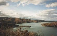
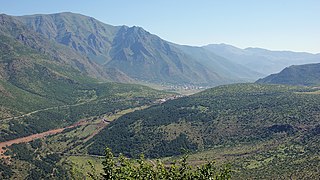
The high-altitude valley is surrounded by even higher mountains on all sides: to the north is the Korab range, containing Mount Korab which, at 2764 metres, is the highest point in both countries; the mountains on the other sides also exceed 2000 metres. The Black Drin flows from the south through a narrow canyon into the valley and leaves it through a similarly steep canyon. Previously the river was notorious for annual floods, as a result of which there are no settlements near the river itself. Since the construction of a reservoir on the Macedonian side, the Debar Lake, the level of the river is regulated.
Little DibërReservoir on the Macedonian side (1986)
The Dibër Valley is fertile. Wolves and bears are still found in the large forests of the valley. A large portion of the inhabitants work in agriculture.
After the collapse of the Ottoman Empire in Europe, the European great powers established the borders of the new Balkan states at the London Conference of 1912–13. As a result, the Dibër Valley was cut in half. The northwestern part, also known as the Little Dibër, was assigned to Albania. The Big Dibër (Albanian: Dibra e Madhe), around the city of Debar, went to the Kingdom of Serbia. The city thus lost a large part of its hinterland. Families were separated and the inhabitants of the Albanian state were no longer able to visit the market in Debar. On the Albanian side, the city of Peshkopi became the new regional centre, the capital of the modern Dibër County and Dibër municipality.
The majority of Dibër's inhabitants are Albanians, who speak a Gheg dialect and are traditionally Muslim. There is a Macedonian Slav minority on both sides of the border.
Albania is a small country in Southern, Southeastern Europe and Western Balkans strategically positioned on the Adriatic and Ionian Sea inside the Mediterranean Sea, with a coastline of about 476 km (296 mi). It is bounded by Montenegro to the northwest, Kosovo to the northeast, North Macedonia to the east and Greece to the southeast and south.
Korab is the highest peak of the eponymous mountain range and the fourth-highest mountain located entirely in the Balkan Peninsula, standing at 2,764 metres.
Tourism in Albania has been a key element to the country's economic activity and is constantly developing. It is characterized by its rich archaeological and cultural heritage dating back to the classical period when Illyrians and Ancient Greeks inhabited the region. Over the course of history, the territory of Albania was occupied and populated by Romans, Byzantines, Venetians and Ottomans. Notably the country features unspoiled beaches, mountainous landscapes, traditional cuisine, archaeological artifacts, unique traditions, low prices and the wild atmosphere of the countryside.
Peshkopi is a town in Dibër County, northeastern Albania. At the 2015 local government reform it became a subdivision of the municipality Dibër. The population at the 2011 census was 13,251.
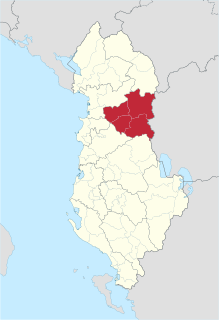
Dibër County is one of the 12 counties of the Republic of Albania, spanning a surface area of 2,586 square kilometres (998 sq mi) with the capital in Peshkopi. The county borders on the counties of Durrës, Elbasan, Kukës, Lezhë, Tirana and the country of North Macedonia. It is divided into the four municipalities of Bulqizë, Dibër, Klos and Mat. The municipalities are further subdivided into 290 towns and villages in total.
Kukës County is a landlocked county in northeastern Albania, with the capital in Kukës. The county spans 2,374 square kilometres (917 sq mi) and had a total population of 74,388 people as of 2021. The county borders on the counties of Dibër, Lezhë and Shkodër and the countries of Montenegro, Kosovo and North Macedonia. It is divided into three municipalities: Has, Kukës and Tropojë. The municipalities are further subdivided into 290 towns and villages in total.
Debar is a city in the western part of North Macedonia, near the border with Albania, off the road from Struga to Gostivar. It is the seat of Debar Municipality. Debar has an ethnic Albanian majority of 74% and is North Macedonia's only city in which ethnic Macedonians do not rank first or second demographically. The official languages are Macedonian and Albanian.
Dibër may refer to:
The Accursed Mountains also known as the Albanian Alps are a mountain group in the western part of the Balkans. It is the southernmost subrange of the 1,000-kilometre-long (621 mi) Dinaric Alps range (Dinarides), extending from northern Albania to southern Kosovo and northeastern Montenegro. Maja Jezercë, standing at 2,694 m (8,839 ft), is the highest point of the Accursed Mountains and of all Dinaric Alps, and the fifth highest peak in Albania. The highest peak in Montenegro, Zla Kolata at 2,534 m (8,314 ft) and the second-highest in Kosovo, Gjeravica at 2,656 m (8,714 ft) are also part of the range. One of the southernmost glacial masses in Europe was discovered in the Albanian part of the range in 2009.
The Radika is a river in southern Kosovo and western North Macedonia, a 70 km (43 mi)-long right tributary to the Black Drin river.
The 41st Infantry Division "Firenze" was an infantry division of the Royal Italian Army during World War II. The Firenze was formed on 15 September 1939 in Florence and named for the city. The division recruited primarily in Tuscany. After the announcement of the Armistice of Cassibile on 8 September 1943 the division resisted German attempts to disbanded it and on 28 September 1943 the division dissolved itself and formed partisan formations, which joined the Albanian National Liberation Army.
Korab is a mountain range in the eastern corner of Albania and the western part of North Macedonia, running along the border between both countries. It forms also the European Green Belt. In Albania, it is also called Vargu lindor, but this term encompasses mountains further north, such as the Koritnik and Gjallica. The highest peak is Mount Korab at 2,751 m (9,026 ft) above sea level. With a prominence of 2,169 m (7,116 ft), Korab is the 18th most prominent mountain peak in the European continent. The mountains are composed of sedimentary rock, including shale, sandstone, dolomite and limestone. The name refers to a Paleochristian sea god.
The Central Mountain Range is a physiogeographical region encompassing the central and eastern edge of Albania. It comprises the mountainous inland extending all the way from the valley of Drin and the mountains of Sharr, Skanderbeg, Korab, and Shebenik-Jabllanicë, through the lakes of Ohrid and Prespa, until it reaches the village of Ersekë and the mountains of Pindus close to the border between the country and Greece.
The Sanjak of Dibra, or the Sanjak of Debar, was one of the sanjaks of the Ottoman Empire. Its capital was Debar, Macedonia. Today, the western part of its territory belongs to Albania and the eastern part to North Macedonia.
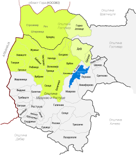
Upper Reka is a geographic and ethnographic subregion of the broader Reka region of western North Macedonia, including settlements within the upper left portion of the Municipality of Mavrovo and Rostuša and of Gostivar Municipality. The region is home to both a Muslim Albanian community and Christian Orthodox population that self identifies as Macedonians, though with some notable exceptions in past and recent times.
Dibër is a municipality in Dibër County, northeastern Albania. The municipality consists of the administrative units of Arras, Fushë-Çidhën, Kala e Dodës, Kastriot, Lurë, Luzni, Maqellarë, Melan, Muhurr, Selishtë, Sllovë, Tomin, Zall-Dardhë, Zall-Reç with Peshkopi constituting its seat. As of the Institute of Statistics estimate from the 2011 census, there were 61,619 inhabitants in Dibër Municipality. The area of the municipality is 937.88 km2 (362.12 sq mi).
Velešta is a village in the municipality of Struga, North Macedonia.
The National Road 6 leads from Milot to Peshkopi.
The Bualli Pass is an 842 metre high mountain pass in Albania. It is part of the National Road 6, which links the Albanian coast to Mat District and the Dibër valley. The west end of the pass is in the watershed of the Mat river and the eastern part is in the watershed of the Drin. Immediately east of the highest point of the pass is the town of Bulqizë.
The Korab-Koritnik Nature Park is a nature park in eastern Albania and forms a section of the European Green Belt, which serves as a retreat for endangered animal and plant species. It encompasses 55,550 hectares (555.5 km2) of alpine mountainous terrain, with valleys, rivers, glacial lakes, caves, canyons, dense coniferous and deciduous forest. The International Union for Conservation of Nature (IUCN) has listed the park as Category IV. Both, Koritnik and Korab has been recognised as an Important Plant Area of international importance by Plantlife.
This page is based on this Wikipedia article Text is available under the CC BY-SA 4.0 license; additional terms may apply. Images, videos and audio are available under their respective licenses.