Springer Mountain is a mountain located in the Chattahoochee National Forest on the border of Fannin and Gilmer counties. Located in the Blue Ridge Mountains in northern Georgia, the mountain has an elevation of about 3,770 feet (1,149 m). Springer Mountain serves as the southern terminus for the Appalachian and Benton MacKaye trails.

Hightower Bald, with an elevation of 4,568 feet (1,392 m) is the fourth-highest peak in the US state of Georgia. It is located in Towns County, Georgia at the North Carolina state line and is within the boundaries of the Southern Nantahala Wilderness of the Chattahoochee National Forest.

Standing Indian Mountain, elevation 5,499 feet (1,676 m), is part of the North Carolina portion of the Southern Nantahala Wilderness within the boundaries of the Nantahala National Forest. The mountain lies along the Appalachian Trail and is the highest point along the Nantahala River.

The Southern Nantahala Wilderness was designated in 1984 and currently consists of 23,473 acres (94.99 km2). Approximately 11,770 acres (47.6 km2) are located in Georgia in the Chattahoochee National Forest and approximately 11,703 acres (47.36 km2) are located in North Carolina in the Nantahala National Forest. The Wilderness is managed by the United States Forest Service and is part of the National Wilderness Preservation System. The highest elevation in the Southern Nantahala Wilderness is the 5,499-foot (1,676 m) peak of Standing Indian Mountain in North Carolina and the lowest elevation is approximately 2,400 feet (730 m). The Appalachian Trail passes through the Wilderness in both states.

Rich Knob, elevation 4,152 feet, is located in Towns County, Georgia. It is part of the Georgia portion of the Southern Nantahala Wilderness and is within the boundaries of the Tallulah Ranger District of the Chattahoochee National Forest. The mountain lies along the Appalachian Trail, which crosses over its eastern flank in Rabun County as it enters North Carolina. Rich Knob also is along the route of The Mountains-To-Sea Trail, East of Rattlesnake Lodge.

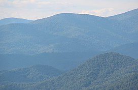
Tray Mountain, with an elevation of 4,430 ft (1,350 m) is the seventh-highest peak in Georgia. The boundary line between White and Towns counties bisects the mountain, but leaves the summit in Towns County. Habersham County lies on a lower part of the mountain, but not on the summit. Tray Mountain is within the borders of the Chattahoochee National Forest and is part of the Tray Mountain Wilderness. The mountain is referred to by some as the grandstand for viewing the Nantahala Mountains in North Carolina and the rest of the Blue Ridge Mountains in Georgia. The Appalachian Trail crosses the peak.
The Appalachian National Scenic Trail spans 14 U.S. states over its roughly 2,200 miles (3,500 km): Georgia, North Carolina, Tennessee, Virginia, West Virginia, Maryland, Pennsylvania, New Jersey, New York, Connecticut, Massachusetts, Vermont, New Hampshire, and Maine. The southern end is at Springer Mountain, Georgia, and it follows the ridgeline of the Appalachian Mountains, crossing many of its highest peaks and running almost continuously through wilderness before reaching the northern end at Mount Katahdin, Maine.

Black Mountain is located in Georgia USA on the boundary between Dawson and Gilmer counties. The summit is the highest point in Dawson County. It is in the Chattahoochee National Forest and is part of the Blue Ridge Wildlife Management Area.

Mount Oglethorpe is a mountain located in Pickens County, Georgia, United States. The southernmost peak in the Blue Ridge Mountains, the mountain has an elevation of 3,288 feet (1,002 m), making it the highest point in Pickens County, and the Atlanta Metropolitan Area.
Rocky Knob is a name used to describe eight different mountain peaks located in the North Georgia mountains that are scattered among four different Georgia counties.

Jacks Knob Trail is a hiking trail that has been designated as a National Recreation Trail in Georgia, US. The trail is 4.5 miles (7.2 km) long and is located in the Chattahoochee National Forest in the Brasstown Ranger District. The trail is managed by the U.S. Forest Service.

Jacks Knob is a mountain located on the border of Towns County and Union County, Georgia, with a peak elevation of 3,813 feet. The Appalachian Trail crosses the southern flank of the mountain and Jacks Knob Trail ends here at an intersection with the Appalachian Trail. Jacks Knob is in the Mark Trail Wilderness of the Chattahoochee National Forest.

Roan Mountain is a 6,277 ft (1,913 m) mountain straddling the North Carolina/Tennessee border in the Unaka Range of the Southern Appalachian Mountains in the Southeastern United States. The range's highpoint, Roan is clad in a dense stand of Southern Appalachian spruce-fir forest, and includes the world's largest natural rhododendron garden, and the longest stretch of grassy bald in the Appalachian range. The Roan Highlands also contain the highest quality remaining stretch of Fraser fir forest throughout the tree's entire range. The Cherokee National Forest and Pisgah National Forest converge atop the mountain, with Roan Mountain State Park located near its northern base. The Appalachian Trail traverses most of the Roan's crest. The Roan High Knob Shelter is the highest back-country shelter on the entire 2,174-mile (3,499 km) trail.

Waterrock Knob is a mountain peak in the U.S. state of North Carolina. It is the highest peak in the Plott Balsams and is the 16th-highest mountain in the Eastern United States.

Tricorner Knob is a mountain in the Great Smoky Mountains, located in the southeastern United States. It has an elevation of 6,120 feet, with 160 feet of clean prominence. The Appalachian and Balsam Mountain trails intersect near the mountain's summit, making Tricorner Knob the great crossroads of the eastern Smokies.
Mount Sequoyah is a mountain in the Great Smoky Mountains, located in the Southeastern United States. It has an elevation of 6,003 feet above sea level. While the Appalachian Trail crosses its summit, Sequoyah is an 11.5-mile (18.5 km) hike from the nearest parking lot, making it one of the most remote places in the Great Smoky Mountains National Park.

Mount Chapman is a mountain in the Great Smoky Mountains, located in the Southeastern United States. It has an elevation of 6,427 feet above sea level. While the mountain is located deep within the Smokies, the Appalachian Trail crosses its eastern slope, coming to within 200 feet (61 m) of the summit. Mount Chapman is among the 10 highest mountains in the Appalachian range, if subpeaks are not included.

Albert Mountain is a mountain in North Carolina's Nantahala National Forest of the Appalachian Mountains. The Appalachian Trail goes along its summit, which is around 5,200 feet (1,600 m) high. A fire tower offers views of the Blue Ridge and the Little Tennessee River valley.

Grassy Mountain is a summit in Murray County, Georgia. At its highest point, the mountain has an elevation of 3,694 feet (1,126 m). It is the second tallest peak in Murray County, if using a 100 feet prominence rule, behind nearby Bald Mountain.