Graybeard Peak is a 7,965-foot (2,428-metre) mountain summit located in Skagit County, Washington.

Icy Peak is a 7,073-foot (2,156-metre) Skagit Range mountain summit located in the North Cascades of Washington state. It is situated in North Cascades National Park at the head of Nooksack Cirque. High ridges connect it to Seahpo Peak and Mount Shuksan. An icefall occupies the northeast cirque, and small glaciers clad all sides of the peak. Precipitation runoff drains into the Nooksack and Baker Rivers.
Pyramid Peak is a 7,189-foot (2,191-metre) mountain summit in the North Cascades Range of Washington, United States. It is located within North Cascades National Park. It rises steeply from Diablo Lake, one of the reservoirs on the Skagit River. It is part of a group of peaks that form the northern end of a chain running south through climbing destinations such as Colonial Peak, Paul Bunyans Stump, and Snowfield Peak. Like many North Cascade peaks, Pyramid Peak is more notable for its large, steep rise above local terrain than for its absolute elevation. Topographic relief is significant as the summit rises 6,400 feet above the Skagit River in 2.5 miles (4 km). Precipitation runoff from the mountain drains into Diablo Lake and Skagit River.

Azurite Peak is an 8,434-foot (2,571-metre) double-summit mountain located at the common boundary point of Okanogan County, Skagit County, and Whatcom County in Washington state. It is part of the Okanogan Range which is a sub-range of the North Cascades Range. Azurite Peak ranks as the 81st-highest summit in the state. Azurite Peak is situated north of Azurite Pass on land administered by the Okanogan–Wenatchee National Forest. The nearest higher neighbor is Tower Mountain, 5.24 miles (8.43 km) to the south-southeast, and Mount Ballard lies 1.97 miles (3.17 km) to the north. Remnants of a small pocket glacier are found on the east aspect. Precipitation runoff from the peak drains north into tributaries of the Skagit River, and south into the Methow River. Topographic relief is significant as the summit rises over 3,000 feet above Mill Creek in one mile (1.6 km). The Pacific Crest Trail traverses the base of Azurite Peak.

Helen Buttes are two prominent summits near the western edge of the North Cascades, in Skagit County of Washington state. The buttes are located four miles northwest of Marblemount, Washington, in the Noisy-Diobsud Wilderness, on land administered by the Mount Baker-Snoqualmie National Forest. The nearest higher neighbor is Diobsud Buttes, 3.11 miles (5.01 km) to the north. Precipitation runoff from Helen Buttes drains into tributaries of the Skagit River.
Porcupine Peak is a 7,762-foot-elevation (2,366-meter) mountain located in Skagit County of Washington state.

Crooked Bum is a 6,937-foot-elevation mountain summit on the crest of the North Cascades in the U.S. state of Washington. It is located in the Okanogan–Wenatchee National Forest on the shared border of Skagit County and Chelan County. It is situated immediately west of Rainy Pass and two miles east of Corteo Peak. The scenic and popular Maple Pass Trail traverses the south slope of the peak while staying above Lake Ann. Precipitation runoff from the north slope of Crooked Bum drains into Granite Creek which is a tributary of the Skagit River, whereas the south side drains into Bridge Creek which is a tributary of the Chelan River.

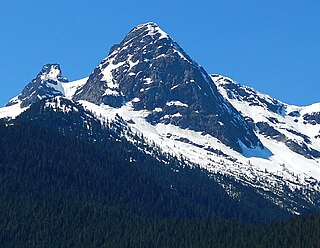
Mount Chaval is a craggy 7,127-foot (2,172-metre) mountain summit located in Skagit County of Washington state. Situated within the Glacier Peak Wilderness, Mount Chaval is positioned west of the crest of the North Cascades Range, approximately 15 miles northeast of the town of Darrington. It has two subsidiary peaks, East Peak and Middle Peak, each 7040 ft. The nearest higher neighbor is Snowking Mountain, 2.51 miles (4.04 km) to the northeast. Precipitation runoff from Mount Chaval drains into tributaries of the Skagit River.

Mineral Mountain is a 6,800-foot (2,100-metre) mountain summit in the Skagit Range of the North Cascades of Washington state. Mineral Mountain is situated in North Cascades National Park and the summit offers views of Mount Shuksan, Icy Peak, and the Picket Range. Easy Peak is set 2 mi (3.2 km) to the east, and the nearest higher neighbor is Ruth Mountain, 3.06 mi (4.92 km) to the west. Precipitation runoff from Mineral Mountain finds its way north into the Chilliwack River, and south into the Baker River.

Logger Butte is a 6,160-foot (1,878-metre) mountain summit near the western edge of the North Cascades, in Skagit County of Washington state. It is located north of Marblemount and Diobsud Buttes, on the shared boundary of North Cascades National Park and the Noisy-Diobsud Wilderness. The nearest higher peak is Electric Butte, 1.0 mi (1.6 km) to the north. Precipitation runoff from Logger Butte drains into tributaries of the Skagit River.

Electric Butte is an unofficially named 6,400-foot (2,000-metre) mountain summit near the western edge of the North Cascades, in Whatcom County of Washington state. It is located north of Marblemount and Logger Butte, within North Cascades National Park. The nearest higher neighbor is Canadian Bacon, 1.44 mi (2.32 km) to the north, with Bacon Peak, 2.01 mi (3.23 km) to the northwest. Precipitation runoff from Electric Butte drains into tributaries of the Skagit River.
Tricouni Peak is an 8,102-foot (2,469-metre) mountain summit located in Skagit County of Washington state. It is situated in North Cascades National Park, north of the North Klawatti Glacier and southeast of the Borealis Glacier. The nearest higher peak is Primus Peak, 0.54 mi (0.87 km) to the west. Precipitation runoff from Tricouni drains into Thunder Creek. The peak is named for the tricouni which was used for traction on ice, and the approach to the peak involves traversing a glacier.

Mount Ballard is an 8,371-foot (2,551-metre) double-summit mountain located in eastern Whatcom County of Washington state. It is part of the Okanogan Range which is a sub-range of the North Cascades Range, and the mountain is situated on land administered by the Okanogan–Wenatchee National Forest. Ballard ranks 84th on Washington's highest 100 peaks. The nearest higher neighbor is Azurite Peak, 2.04 miles (3.28 km) to the south. Precipitation runoff from Mount Ballard drains into Mill Creek and Slate Creek, both tributaries of the Skagit River. Topographic relief is significant as the summit rises approximately 4,000 feet above Mill Creek in one mile (1.6 km).

The Chopping Block is a 6,819-foot (2,078-metre) mountain summit located in the Picket Range within North Cascades National Park in the state of Washington. The mountain is officially named Pinnacle Peak on maps, but hardly anyone calls it by that name. The nearest higher peak is Mount Degenhardt, 0.6 mi (0.97 km) to the northeast. The Chopping Block can be seen from the North Cascades National Park Newhalem visitor center, weather permitting. Precipitation runoff from the peak drains into Goodell Creek, a tributary of the Skagit River.

Granite Mountain is a 6,692-foot (2,040-metre) mountain summit located in the Skagit Range, which is a subset of the North Cascades in Whatcom County of Washington state. It is situated 1.7 mi (2.7 km) south of Mount Chardonnay, and 1.2 mi (1.9 km) northwest of Hannegan Peak in the Mount Baker Wilderness, which is managed by the Mount Baker-Snoqualmie National Forest. Precipitation runoff from the mountain drains into tributaries of the Fraser River and the Nooksack River.

Pinnacle Peak is a 7,386 ft (2,251 m) mountain summit in the North Cascades Range of Washington, United States. It is located within North Cascades National Park, between Pyramid Peak and Paul Bunyans Stump, which is the nearest higher peak. It rises steeply from Diablo Lake, one of the reservoirs on the Skagit River. It is part of a group of peaks that form the northern end of a chain running south through climbing destinations such as Colonial Peak and Snowfield Peak. Like many North Cascade peaks, Pinnacle Peak is more notable for its large, steep rise above local terrain than for its absolute elevation. Precipitation runoff from the mountain drains into Diablo Lake and Skagit River. The approach is via the Pyramid Lake Trail, starting near Diablo Dam on the North Cascades Highway. From the lake, there is route-finding up Pyramid Arm to Colonial Glacier.
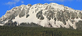
Sauk Mountain is a 5,545-foot (1,690-metre) mountain summit located in Skagit County of Washington state. It is situated immediately north of Rockport State Park and the North Cascades Highway, on land managed by the Mount Baker-Snoqualmie National Forest. Part of the North Cascades, Sauk Mountain is positioned west of the crest of the Cascade Range, approximately nine miles east of Concrete, Washington, and 17 miles north of the town of Darrington. The nearest higher peak is Helen Buttes, 5.86 miles (9.43 km) to the northeast. A popular two-mile trail provides hikers with good views from the craggy summit of Mount Baker, Mount Shuksan, Mount Chaval, and the Picket Range. Precipitation runoff from Sauk Mountain drains into tributaries of the Skagit River.
Indecision Peak is a 7,945 ft (2,420 m) double-summit mountain located in the North Cascades in the U.S. state of Washington. It situated in North Cascades National Park, on the crest of the Cascade Range, on the shared border of Chelan County with Skagit County. Despite its position only 5 mi (8.0 km) west of the North Cascades Highway, it is not visible from any road. Its nearest higher neighbor is Mount Arriva, 0.92 mi (1.48 km) to the north. The first ascent of the summit was made August 2, 1972, by Bill Arundell, Frank King, Marilyn and Stan Jensen, and Joanne Williams. The lower northeast summit is known as Meulefire Peak (~7,930 ft), which is a portmanteau of Meulemans and Firey, the names of the first mountaineers to climb it in 1966.

Skagit Peak is a 6,824-foot (2,080-metre) mountain summit located in the North Cascades, in Whatcom County of Washington state. It is situated on the western side of the Cascade crest, at the western edge of the Pasayten Wilderness, on land managed by the Okanogan–Wenatchee National Forest. Skagit Peak is part of the Hozameen Range, a subset of the North Cascades which also includes Hozomeen Mountain to the north, and Jack Mountain to the south. Precipitation runoff from this mountain drains into the Skagit River via Three Fools Creek and Ross Lake.
Mount Watson is a 6,220-foot-elevation (1,900-meter) summit located in the North Cascades, in Whatcom County of Washington state.