Disappointment Peak (California)

Last updated
Disappointment Peak
Disappointment Peak CA.jpg
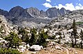
South aspect, seen from JMT
Highest point
Elevation 13,917 ft (4,242 m) [1]
Prominence 137 ft (42 m) [2]
Parent peak Middle Palisade (14,018 ft) [3] \
Isolation 0.19 mi (0.31 km) [3]
Listing Sierra Peaks Section
Vagmarken Club Sierra Crest List [4]
Coordinates 37°04′04″N118°28′03″W / 37.0679033°N 118.4675575°W / 37.0679033; -118.4675575 Coordinates: 37°04′04″N118°28′03″W / 37.0679033°N 118.4675575°W / 37.0679033; -118.4675575 [5]
Geography
Relief map of California.png
Red triangle with thick white border.svg
Disappointment Peak
Location in California
Usa edcp relief location map.png
Red triangle with thick white border.svg
Disappointment Peak
Disappointment Peak (the United States)
Location Kings Canyon National Park
Fresno / Inyo Counties
California, U.S.
Parent range Sierra Nevada
Topo map USGS Split Mountain
Geology
Age of rock Cretaceous
Mountain type Fault block
Type of rock Granodiorite [6]
Climbing
First ascent 1919
Easiest route class 4+ [3]

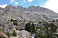
Disappointment Peak is a 13,917-foot-elevation (4,242 meter) summit located on the shared boundary of Fresno County and Inyo County in California, United States. [5]

Contents

Description

The peak is set on the crest of the Sierra Nevada mountain range in the Palisades area. It also straddles the border shared by Kings Canyon National Park and John Muir Wilderness. It is situated 0.2 miles (0.32 km) southeast of line parent Middle Palisade, and 1.2 miles (1.9 km) west of The Thumb. Topographic relief is significant as the summit rises 3,300 feet (1,006 meters) above Palisades Lakes in approximately one mile. Precipitation runoff from this mountain drains north to Big Pine Creek, as well as south and west into Palisade Creek which is a tributary of the Middle Fork Kings River. The John Muir Trail, which passes below the south base of the peak, provides an approach option.

History

The first ascent of the summit was made July 20, 1919, by J. M. Davies, A. L. Jordan, and H. H. Bliss via the Southwest Chute, and the Northeast Couloir was first climbed by Norman Clyde on June 20, 1930. [7] The West Face (class 5.10) was first climbed in September 1986 by Galen Rowell and Dan Frankl. [8] This mountain's toponym has been officially adopted by the United States Board on Geographic Names. [5] The toponym recognizes the "disappointment" the first ascent party felt when finding themselves on this summit instead of Middle Palisade, which they thought they were climbing. [9] They left a note in a can which stated: "The undersigned made a first ascent of this peak this day and were disappointed not to find it the highest point of the Middle Palisade. We hereby christen this summit 'Peak Disappointment'". [10] It would be exactly twenty years to the day after the disappointing first ascent, that the difficult traverse from Disappointment Peak to Middle Palisade would first be accomplished by David Brower, Bruce Meyer, and Keith Taylor. [11]

Climate

Disappointment Peak is located in an alpine climate zone. [12] Most weather fronts originate in the Pacific Ocean, and travel east toward the Sierra Nevada mountains. As fronts approach, they are forced upward by the peaks (orographic lift), causing them to drop their moisture in the form of rain or snowfall onto the range. This climate supports the Middle Palisade Glacier on the north slope below the summit.

See also

Related Research Articles

Norman Clyde

Norman Clyde was a mountaineer, mountain guide, freelance writer, nature photographer, and self-trained naturalist. He is well known for achieving over 130 first ascents, many in California's Sierra Nevada and Montana's Glacier National Park. He also set a speed climbing record on California's Mount Shasta in 1923. The Bancroft Library at the University of California, Berkeley has 1467 articles written by Clyde in its archives.

Mount Agassiz (California) Mountain of the Sierra Nevada in California, United States

Mount Agassiz, at 13,899 feet (4,236 m), is one of the twenty highest peaks of California. It is the northernmost and easiest to climb of the major Palisades summits. This peak is not to be confused with the 9967ft peak by the same name in Desolation Wilderness, also in the California Sierra.

Mount Winchell

Mount Winchell, a thirteener, is among the thirty highest peaks of California. It is in the Palisades region of the Sierra Nevada, on the Sierra Crest between Mount Agassiz and Thunderbolt Peak.

Mount Fiske

Mount Fiske is a 13,503-foot-elevation mountain summit located near the crest of the Sierra Nevada mountain range, in Fresno County of northern California, United States. It is situated in northern Kings Canyon National Park, 23 miles (37 km) west of the community of Big Pine, 0.83 miles (1.34 km) east of Mount Huxley, and two miles south of Mount Darwin, which is the nearest higher neighbor. Mount Fiske ranks as the 60th highest summit in California.

Langille Peak Mountain in California, United States of America

Langille Peak is a 12,018-foot-elevation mountain summit located near the crest of the Sierra Nevada mountain range, in Fresno County of northern California, United States. It is situated in northern Kings Canyon National Park, 19 miles (31 km) west-southwest of the community of Big Pine, 3 miles (4.8 km) south of Mount Thompson, 2.8 miles (4.5 km) southwest of Mount Goode, and 2.1 miles (3.4 km) east of Black Giant. Topographic relief is significant as the east aspect rises 3,100 feet (945 meters) above LeConte Canyon in less than one mile. The approach to this remote peak is made via the John Muir Trail.

Mount Gayley

Mount Gayley is a 13,510-foot-elevation mountain summit located one mile east of the crest of the Sierra Nevada mountain range in Inyo County, California, United States. It is situated in the Palisades area of the John Muir Wilderness, on land managed by Inyo National Forest. It is approximately 13 miles (21 km) west-southwest of the community of Big Pine, 0.67 miles (1.08 km) southwest of Temple Crag, and 0.5 miles (0.80 km) north-northeast of parent Mount Sill. Mount Gayley ranks as the 59th highest summit in California.

Cloudripper Mountain peak of the Sierra Nevada in California, United States

Cloudripper is a 13,525-foot-elevation mountain summit located two miles east of the crest of the Sierra Nevada mountain range in Inyo County of northern California, United States. It is situated in the Palisades area of the John Muir Wilderness, on land managed by Inyo National Forest. It is approximately 14 miles (23 km) west of the community of Big Pine, 1.1 miles (1.8 km) north-northeast of Picture Puzzle, and 2.1 miles (3.4 km) south of parent Mount Agassiz. Cloudripper ranks as the 58th highest summit in California, and the highest point of the Inconsolable Range.

Picture Puzzle Mountain peak of the Sierra Nevada in California, United States

Picture Puzzle, also known as Picture Puzzle Peak, is a 13,297-foot-elevation mountain summit located one mile east of the crest of the Sierra Nevada mountain range in Inyo County of northern California, United States. It is situated in the Palisades area of the John Muir Wilderness, on land managed by Inyo National Forest. It is approximately 14.5 miles (23.3 km) west of the community of Big Pine, one mile north of Bishop Pass, 1.2 miles (1.9 km) north-northwest of Mount Agassiz, and 1.1 miles (1.8 km) south-southwest of parent Cloudripper. Picture Puzzle ranks as the 90th highest summit in California, and the third highest peak of the Inconsolable Range.

North Guard

North Guard is a remote 13,327-foot-elevation mountain summit located near the northern end of the Great Western Divide of the Sierra Nevada mountain range, in Tulare County of northern California. It is situated in Kings Canyon National Park, 0.9 miles (1.4 km) southeast of Mount Farquhar, and 0.6 miles (0.97 km) north-northwest of Mount Brewer, which is the nearest higher neighbor. Topographic relief is significant as the east aspect rises 3,858 feet (1,176 meters) above East Lake in three miles. North Guard ranks as the 87th highest summit in California, and the second highest point of the northern Great Western Divide. It's not as high as Mount Brewer, but offers better climbing and is considered one of the classic climbing routes in the Sierra Nevada.

The Hermit (California mountain)

The Hermit is a 12,328-foot-elevation mountain summit located west of the crest of the Sierra Nevada mountain range, in Fresno County of northern California, United States. It is situated in northern Kings Canyon National Park, 2.5 miles (4.0 km) east of Emerald Peak, and 2.5 miles (4.0 km) west of Mount Darwin. Topographic relief is significant as the north aspect rises 2,500 feet (762 meters) above Evolution Valley in less than one mile. The John Muir Trail passes to the east and north of this landmark, providing an approach. This geographical feature was named by Sierra Club explorer Theodore Solomons in 1895 as he wrote: "The traveler will be greatly attracted by a very sharp peak or butte that rises on the south wall. From its isolated position as viewed from the valley we called it the Hermit."

Mount Powell (California)

Mount Powell is a 13,364-foot-elevation mountain summit located on the crest of the Sierra Nevada mountain range in California, United States. It is situated on the shared boundary of Kings Canyon National Park with John Muir Wilderness, and along the common border of Fresno County with Inyo County. It is also 19 miles (31 km) west of the community of Big Pine, and 1.17 miles (1.88 km) west of Mount Thompson, which is the nearest higher neighbor. Mount Powell ranks as the 81st highest peak in California, and the 10th highest of the Evolution Region of the Sierra Nevada. The west summit is unofficially known as "Point John." Two other peaks on the mountain are informally called "Point Wesley" (13,356 ft) in the middle, and "Point Powell" (13,360+ ft) one-half mile to the east.

Mount Lamarck

Mount Lamarck is a 13,417-foot-elevation mountain summit located on the crest of the Sierra Nevada mountain range in northern California, United States. It is situated on the shared boundary of Kings Canyon National Park with John Muir Wilderness, and along the common border of Fresno County with Inyo County. It is 20 miles (32 km) southwest of the community of Bishop, and 1.9 miles (3.1 km) north of Mount Darwin. Subsidiary peak Mount Lamarck North ranks as the 67th highest summit in California, and the sixth highest in the Evolution Region. Topographic relief is significant as the east aspect rises 4,290 feet (1,307 meters) above Lake Sabrina in three miles, and the west aspect rises 3,600 feet (1,097 meters) above Evolution Valley in three miles.

Devils Crags

Devils Crags is a 12,424-foot-elevation mountain summit located west of the crest of the Sierra Nevada mountain range, in Fresno County of northern California, United States. This jagged line of 11 pinnacles is situated at the southern end of Black Divide in Kings Canyon National Park, 1.88 miles (3.03 km) south of The Citadel, and one mile southeast of Wheel Mountain, which is the nearest higher neighbor. Devils Crags ranks as the 299th highest summit in California. Topographic relief is significant as it rises 4,200 feet (1,280 meters) above Middle Fork Kings River in approximately two miles. An approach to this remote peak is made possible via the John Muir Trail which passes nearby to the east. The class 5 Northwest Arête is considered one of the classic climbing routes in the Sierra Nevada.

Mount McDuffie

Mount McDuffie is a 13,291-foot-elevation mountain summit located west of the crest of the Sierra Nevada mountain range, in Fresno County of northern California, United States. This peak is situated in Kings Canyon National Park, 1.9 miles (3.1 km) northwest of The Citadel, and two miles south of Black Giant, which is the nearest higher neighbor. McDuffie ranks as the 93rd highest summit in California, and the second-highest point on Black Divide. Topographic relief is significant as it rises nearly 4,900 feet (1,493 meters) above Middle Fork Kings River in approximately 2.5 miles. An approach to this remote peak is made possible via the John Muir Trail.

Giraud Peak

Giraud Peak is a 12,608-foot-elevation mountain summit located west of the crest of the Sierra Nevada mountain range, in Fresno County of northern California, United States. It is situated in the Palisades area of northern Kings Canyon National Park, 3.0 miles (4.8 km) southwest of North Palisade, and 1.5 miles (2.4 km) southwest of Columbine Peak, the nearest higher neighbor. Giraud Peak ranks as the 258th-highest summit in California. Topographic relief is significant as the west aspect rises 4,400 feet (1,340 meters) above LeConte Canyon in less than two miles. On the direct opposite side of the canyon The Citadel stands guard. The first ascent of the summit was made September 1, 1925, by Norman Clyde via the east arête.

Mount Baldwin (California)

Mount Baldwin is a 12,614-foot-elevation mountain summit located in the Sierra Nevada mountain range in Mono County of northern California, United States. It is situated in the John Muir Wilderness on land managed by Inyo National Forest. It is four miles north of Red and White Mountain, and approximately 10.5 miles (16.9 km) southeast of the community of Mammoth Lakes. The nearest higher neighbor is Red Slate Mountain, 2 miles (3.2 km) to the south-southwest. Baldwin ranks as the 257th highest summit in California. Topographic relief is significant as the east aspect rises 3,775 feet (1,150 meters) above McGee Canyon in 1.5 mile. The first ascent of the summit was made July 2, 1928, by Norman Clyde, who is credited with 130 first ascents, most of which were in the Sierra Nevada.

Mount Gilbert (California) Mountain in California, United States

Mount Gilbert is a 13,106-foot (3,995 m) mountain located on the crest of the Sierra Nevada range in California, United States. It is situated on the shared boundary of Kings Canyon National Park and John Muir Wilderness, and along the common border of Fresno County and Inyo County. It is 18 miles (29 km) west of the community of Big Pine, 0.8 mile northwest of Mount Johnson, and one mile southeast of Mount Thompson, which is it's nearest higher neighbor. Mount Gilbert ranks as the 127th-highest summit in California. Topographic relief is significant as the south aspect rises 3,900 feet (1,189 m) above LeConte Canyon in less than two miles, and the northern aspect rises 3,340 feet above South Lake in 2.5 miles.

Mount Johnson (California)

Mount Johnson is a 12,871-foot-elevation mountain summit located on the crest of the Sierra Nevada mountain range in California, United States. It is situated on the boundary between Kings Canyon National Park and John Muir Wilderness, and along the county line between Fresno County and Inyo County. It is also 18 miles (29 km) west of the community of Big Pine, 0.9 miles (1.4 km) southeast of Mount Gilbert, and one mile (1.6 km) west-northwest of Mount Goode. Mount Johnson ranks as the 187th-highest summit in California. Topographic relief is significant as the southwest aspect rises 3,670 feet above LeConte Canyon in 1.5 mile, and the north aspect rises 3,100 feet above South Lake in 2.5 miles.

Kettle Peak

Kettle Peak is a mountain with a summit elevation of 11,010 feet (3,356 m) located in the Sierra Nevada mountain range, in Mono County of northern California, United States. The summit is set in the Hoover Wilderness on land managed by Humboldt–Toiyabe National Forest, and is less than one-half mile outside the boundary of Yosemite National Park. The peak is situated approximately three miles southwest of Twin Lakes, three miles south of Victoria Peak, 2.9 miles northeast of Crown Point, and 3.1 miles northwest of Matterhorn Peak. Topographic relief is significant as the west aspect rises over 2,600 feet (792 meters) above Robinson Creek in one mile.

Observation Peak (California)

Observation Peak is a 12,362-foot-elevation summit located in Fresno County, California, United States.

References

  1. R. J. Secor, The High Sierra Peaks, Passes, Trails, 2009, Third Edition, Mountaineers Books, ISBN   9781594857386, p. 227
  2. "Disappointment Peak, California". Peakbagger.com. Retrieved 2022-05-02.
  3. 1 2 3 "Disappointment Peak - 13,917' CA". listsofjohn.com. Retrieved 2022-05-02.
  4. "Vagmarken Sierra Crest List". Angeles Chapter, Sierra Club . Retrieved 2022-05-02.
  5. 1 2 3 "Disappointment Peak". Geographic Names Information System . United States Geological Survey . Retrieved 2022-05-02.
  6. Stratotype Inventory—Sequoia and Kings Canyon National Parks, California, National Park Service
  7. David R. Brower and Fred L. Jones, A Climber's Guide to the High Sierra (1954)
  8. R. J. Secor, The High Sierra Peaks, Passes, Trails, 2009, Third Edition, Mountaineers Books, ISBN   9781594857386, p. 227
  9. R. J. Secor, The High Sierra Peaks, Passes, Trails, 2009, Third Edition, Mountaineers Books, ISBN   9781594857386, p. 227
  10. Peter Browning (1986), Place Names of the Sierra Nevada: From Abbot to Zumwalt, Wilderness Press, ISBN   9780899970479, p. 57
  11. Stephen Porcella, Cameron Burns (1998), Climbing California's Fourteeners: The Route Guide to the Fifteen Highest Peaks, Mountaineers Books, ISBN   9780898865554, p. 151
  12. "Climate of the Sierra Nevada". Encyclopædia Britannica .