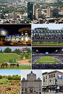
Lexington is the second-largest city in Kentucky and the 60th-largest city in the United States. Known as the "Horse Capital of the World," it is the heart of the state's Bluegrass region. Notable locations in the city include the Kentucky Horse Park, The Red Mile and Keeneland race courses, Rupp Arena, Transylvania University, the University of Kentucky, and Bluegrass Community and Technical College. Lexington ranks 10th among US cities in college education rate, with 39.5% of residents having at least a bachelor's degree.

Lexington Park is a census-designated place (CDP) in St. Mary's County, Maryland, United States, and the principal community of the Lexington Park, Maryland Micropolitan Statistical Area. The population was 11,626 at the 2010 census.

Deep Creek Lake State Park is a public recreation area occupying more than 1,100 acres (450 ha) on the northeast side of Deep Creek Lake in Garrett County, Maryland, in the United States. The park features water activities, camping facilities, and recreational trails and is located about 18 miles (29 km) south of Interstate 68 on U.S. Route 219.
The Potomac Heritage Trail, also known as the Potomac Heritage National Scenic Trail or the PHT, is a designated National Scenic Trail corridor spanning parts of the mid-Atlantic and upper southeastern regions of the United States that will connect various trails and historic sites in the states of Virginia, Maryland, and Pennsylvania and the District of Columbia. The trail network includes 710 miles (1,140 km) of existing and planned sections, tracing the outstanding natural, historical, and cultural features of the Potomac River corridor, the upper Ohio River watershed in Pennsylvania and western Maryland, and a portion of the Rappahannock River watershed in Virginia. The trail is managed by the National Park Service.

Buckhorn Lake, located south of Buckhorn, Kentucky, United States and northwest of Hazard, Kentucky off Kentucky Route 28, is a 1,230-acre (5 km2) reservoir created by the United States Army Corps of Engineers in 1967 by impounding the Kentucky River.
The Battle of Lexington State Historic Site is state-owned property located in the city of Lexington, Missouri. The site was established in 1958 to preserve the grounds where an American Civil War battle took place in 1861 between Confederate troops led by Major-General Sterling Price and Federal troops led by Colonel James A. Mulligan. The site offers a short battlefield loop trail, picnicking, and tours of the battlegrounds and Oliver Anderson mansion.

Walter B. Huber was a U.S. Representative from Ohio.
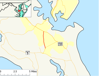
Maryland Route 235 (MD 235) is a state highway in the U.S. state of Maryland. Known as Three Notch Road, the state highway runs 30.63 miles (49.29 km) between its southern intersection with MD 5 in Ridge and its northern intersection with MD 5 near Mechanicsville. While the southern part of the state highway is a quiet rural road, the northern part of MD 235 is a four- to six-lane divided highway connecting Naval Air Station Patuxent River and the Washington, D.C., metro area in conjunction with MD 5. Three Notch Road has been the main highway between northern St. Mary's County and Point Lookout since the colonial era. The highway was reconstructed as the modern MD 235 between 1923 and 1938. The state highway was then completely rebuilt during World War II to serve the recently established NAS Patuxent River. Between 1960 and 1985, MD 235 was converted into a four-lane divided highway to the west and north of the military base. In the face of increasing activity at the base, the highway adjacent to NAS Patuxent River was expanded to six lanes in the early 2000s.

Purse State Park is a former Maryland state park located on the Potomac River in Charles County that has been subsumed into the 1,365-acre (552 ha) Nanjemoy Wildlife Management Area. As the Purse Area, the former park is known for fossil hunting on the beaches of Wades Bay at the southern end of the Nanjemoy WMA. Fossil discoveries have included shark teeth and Cibicides.

This is a list of the National Register of Historic Places listings in Lexington, Virginia.
This is a list of National Register of Historic Places properties and districts in downtown Baltimore, Maryland, United States. Many other properties are located in other parts of the city; for these, see National Register of Historic Places listings in Baltimore, Maryland.
Great Mills is an unincorporated community in St. Mary's County, Maryland, United States. Great Mills High School serves the lower end of the county, including the town of Lexington Park.

This is a list of the National Register of Historic Places listings in Lexington County, South Carolina.
Maryland Route 237 is a state highway in the U.S. state of Maryland. Known as Chancellors Run Road, the route runs 2.95 miles (4.75 km) from MD 246 near Lexington Park north to MD 235 in California. MD 237, which was designated in the mid-1980s, bypasses the center of Lexington Park through the suburban area surrounding Naval Air Station Patuxent River. The state highway was expanded to a four-lane divided highway between 2008 and 2010 in response to increased activity at the military base.

Maryland Route 246 is a state highway in the U.S. state of Maryland. Known for most of its length as Great Mills Road, the state highway runs 3.35 miles (5.39 km) from MD 5 in Great Mills east to the entrance to Naval Air Station Patuxent River just east of the highway intersection with MD 235 in Lexington Park. In conjunction with MD 5, MD 246 connects NAS Patuxent River and the suburban area surrounding the military base with Leonardtown. The state highway was originally constructed around 1920. MD 246 extended east onto land now occupied by NAS Patuxent River to serve a ferry from St. Mary's County to the southern end of Calvert County. The ferry was discontinued and the state highway's eastern terminus was rolled back to MD 235 when NAS Patuxent River was constructed during World War II; the remainder of MD 246 was upgraded as a military access project. MD 246 was expanded to a multi-lane highway in the 1990s.

Maryland Route 489 is a state highway in the U.S. state of Maryland. Known as Park Hall Road, the state highway runs 1.27 miles (2.04 km) from MD 5 east to MD 235 within Park Hall Estates in southern St. Mary's County. MD 489, which serves as a connector between MD 5 and MD 235 south of Lexington Park, was assigned to Park Hall Road in 1956.
Rockcreek-Lexington Road is an irregular-shaped neighborhood in Louisville, Kentucky, United States. Its boundaries are Seneca Park and Briar Hill Road to the west, Cannons Lane to the east, Interstate 64 to the south, and Lexington Road to the north. Also included are "areas immediately adjoining Shelbyville Rd. from Cannons Ln. to Fairfax Ave. and those along Nanz Ave. from Cannons Ln. to Macon Ave."

Maryland Route 712 is a state highway in the U.S. state of Maryland. Known as Forest Park Road, the state highway runs 1.11 miles (1.79 km) from MD 235 north to an entrance to Naval Air Station Patuxent River within Lexington Park in eastern St. Mary's County. MD 712 was constructed in the mid-1940s as a military access project.

Discovery is an unincorporated community in Frederick County, Maryland, United States. Discovery is located along Maryland Route 194 near the southern border of Walkersville. Prior to 2010, the community was part of the Discovery-Spring Garden census-designated place.

