Dragon Peak (California)

Last updated

Dragon Peak
Dragon Peak.jpg
Northwest aspect
Highest point
Elevation 12,955 ft (3,949 m) [1] [2]
Prominence 296 ft (90 m) [3]
Parent peak Mount Gould (13,011 ft) [4]
Isolation 0.75 mi (1.21 km) [4]
Listing Sierra Peaks Section
Vagmarken Club Sierra Crest List [5]
Coordinates 36°47′23″N118°22′33″W / 36.7898467°N 118.3758937°W / 36.7898467; -118.3758937 [6]
Geography
Relief map of California.png
Red triangle with thick white border.svg
Dragon Peak
Location in California
Usa edcp relief location map.png
Red triangle with thick white border.svg
Dragon Peak
Dragon Peak (the United States)
Location
Parent range Sierra Nevada
Topo map USGS Mount Clarence King
Geology
Mountain type Fault block
Rock type Metamorphic rock [7]
Climbing
First ascent 1920
Easiest route class 4 scrambling [4]

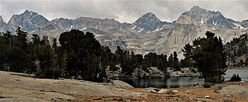
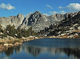
Dragon Peak is a 12,955-foot-elevation (3,949-meter) mountain summit located on the crest of the Sierra Nevada mountain range in northern California. [6] It is situated on the common border of Fresno County with Inyo County, as well as the boundary shared by John Muir Wilderness and Kings Canyon National Park. It is 10 miles (16 km) west of the community of Independence, and 1.3 miles (2.1 km) south of Black Mountain. Dragon Peak ranks as the 161st-highest summit in California. [4] Topographic relief is significant as the north aspect rises 1,900 feet (580 meters) above Dragon Lake in less than one mile. This mountain is habitat for the endangered Sierra Nevada bighorn sheep, which restricts climbing from July through December, so most ascents are made in the spring. The first ascent of the summit was made in 1920 by either Norman Clyde, or Fred Parker and J. E. Rother. [8] The John Muir Trail traverses two miles west of this peak, providing an approach option. The mountain is so named because of the shape of its outline as seen from Rae Lakes. [9]

Contents

Climate

According to the Köppen climate classification system, Dragon Peak has an alpine climate. [10] Most weather fronts originate in the Pacific Ocean, and travel east toward the Sierra Nevada mountains. As fronts approach, they are forced upward by the peaks (orographic lift), causing them to drop their moisture in the form of rain or snowfall onto the range. Precipitation runoff from this mountain drains east to the Owens Valley via Independence Creek, and west into the Kings River watershed.

See also

References

  1. John Moynier, Claude Fiddler (1993), Sierra Classics: 100 Best Climbs in the High Sierra, Chockstone Press, ISBN   9780934641609, p. 106
  2. Francis Peloubet Farquhar (1926), Place Names of the High Sierra, Sierra Club, p. 22.
  3. "Dragon Peak, California". Peakbagger.com. Retrieved May 22, 2022.
  4. 1 2 3 4 "Dragon Peak - 12,959' CA". ListsOfJohn.com. Retrieved May 22, 2022.
  5. "Vagmarken Sierra Crest List". Angeles Chapter, Sierra Club . Retrieved May 22, 2022.
  6. 1 2 "Dragon Peak". Geographic Names Information System . United States Geological Survey, United States Department of the Interior . Retrieved May 22, 2022.
  7. Joseph E. Brown (1984), The Sierra Club Guides to the National Parks of the Pacific Southwest and Hawaii, Random House, ISBN   9780394724904, p. 114.
  8. Fred L. Jones, A Climber’s Guide to the High Sierra (1954)
  9. Erwin G. Gudde, William Bright (2010), California Place Names: The Origin and Etymology of Current Geographical Names, University of California Press, ISBN   9780520266193, p. 113.
  10. "Climate of the Sierra Nevada". Encyclopædia Britannica .
Dragon Peak (left), Falcor Peak, and Mount Rixford (right) seen from north at Rae Lakes. Dragon and Rixford.jpg
Dragon Peak (left), Falcor Peak, and Mount Rixford (right) seen from north at Rae Lakes.