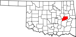
Duchess Landing, Oklahoma

Last updated

Duchess Landing
CDP
USA Oklahoma location map.svg
Red pog.svg
Duchess Landing
Location within the state of Oklahoma
Coordinates: 35°23′54″N95°24′59″W / 35.39833°N 95.41639°W / 35.39833; -95.41639
Country United States
State Oklahoma
County McIntosh
Area
[1]
  Total5.94 sq mi (15.38 km2)
  Land5.94 sq mi (15.38 km2)
  Water0.00 sq mi (0.00 km2)
Elevation
[2]
610 ft (190 m)
Population
 (2020)
  Total157
  Density26.44/sq mi (10.21/km2)
Time zone UTC-6 (Central (CST))
  Summer (DST) UTC-5 (CST)
FIPS code 40-21760
GNIS feature ID2408691 [2]

Duchess Landing is a census-designated place (CDP) in McIntosh County, Oklahoma, United States. The population was 157 at the 2020 census.

Contents

Geography

According to the United States Census Bureau, the CDP has a total area of 5.9 square miles (15 km2), all land.

Demographics

Historical population
CensusPop.Note
2020 157
U.S. Decennial Census [3]

As of the census [4] of 2000, there were 95 people, 35 households, and 26 families residing in the CDP. The population density was 16.0 people per square mile (6.2/km2). There were 40 housing units at an average density of 6.7/sq mi (2.6/km2). The racial makeup of the CDP was 61.05% White, 36.84% Native American, and 2.11% from two or more races.

There were 35 households, out of which 37.1% had children under the age of 18 living with them, 74.3% were married couples living together, 2.9% had a female householder with no husband present, and 22.9% were non-families. 22.9% of all households were made up of individuals, and 8.6% had someone living alone who was 65 years of age or older. The average household size was 2.71 and the average family size was 3.11.

In the CDP, the population was spread out, with 28.4% under the age of 18, 5.3% from 18 to 24, 27.4% from 25 to 44, 29.5% from 45 to 64, and 9.5% who were 65 years of age or older. The median age was 36 years. For every 100 females, there were 90.0 males. For every 100 females age 18 and over, there were 83.8 males.

The median income for a household in the CDP was $13,750, and the median income for a family was $46,250. Males had a median income of $13,750 versus $30,156 for females. The per capita income for the CDP was $13,075. There were no families and 15.0% of the population living below the poverty line, including no under eighteens and none of those over 64.

Related Research Articles

<span class="mw-page-title-main">Mignon, Alabama</span> CDP in Alabama, United States

Mignon is a census-designated place (CDP) in Talladega County, Alabama, United States. At the 2020 census, the population was 1,186.

<span class="mw-page-title-main">Dot Lake, Alaska</span> CDP in Alaska, United States

Dot Lake is a census-designated place (CDP) in Southeast Fairbanks Census Area, Alaska, United States. It is located on the Alaska Highway between Delta Junction and Tok. The population was 13 at the 2010 census, down from 19 in 2000.

Birch Creek is a census-designated place (CDP) in Yukon-Koyukuk Census Area, Alaska, United States. The population was 33 at the 2010 census, up from 28 in 2000.

<span class="mw-page-title-main">Lake Kathryn, Florida</span> Census-designated place in Florida

Lake Kathryn is a census-designated place (CDP) in Lake County, Florida, United States. The population was 920 at the 2010 census. The area is also known as Lake Kathryn Heights. It is part of the Orlando–Kissimmee Metropolitan Statistical Area.

<span class="mw-page-title-main">Reserve, Montana</span> CDP in Montana, United States

Reserve is a census-designated place (CDP) in Sheridan County, Montana, United States. The population was 23 at the 2010 census.

<span class="mw-page-title-main">Huerfano, New Mexico</span> CDP in New Mexico, United States

Huerfano is a census-designated place (CDP) in San Juan County, New Mexico, United States. The population was 104 at the 2000 census. It is part of the Farmington Metropolitan Statistical Area. Huerfano is named after El Huerfano Mountain, located a mile to the northeast.

<span class="mw-page-title-main">East Dunseith, North Dakota</span> CDP in North Dakota, United States

East Dunseith is a census-designated place (CDP) in Rolette County, North Dakota, United States. The population was 500 at the 2020 census.

<span class="mw-page-title-main">Peavine, Oklahoma</span> Census-designated place in Oklahoma, United States

Peavine is a census-designated place (CDP) in Adair County, Oklahoma, United States. The population was 423 at the 2010 census.

<span class="mw-page-title-main">Zion, Oklahoma</span> Census-designated place in Oklahoma, United States

Zion is a census-designated place (CDP) in Adair County, Oklahoma, United States. The population was 41 at the 2010 census.

Bull Hollow is an unincorporated community and census-designated place (CDP) in Delaware County, Oklahoma, United States. The population was 67 at the 2010 census.

Dripping Springs is an unincorporated community and census-designated place (CDP) in Delaware County, Oklahoma, United States. The population was 50 at the 2010 census, up from the figure of 41 recorded in 2000.

<span class="mw-page-title-main">Zena, Oklahoma</span> CDP in Oklahoma, United States

Zena is a census-designated place (CDP) in Delaware County, Oklahoma, United States, along State Highway 127. The population was 122 at the 2010 census. Established on Courthouse Prairie in District 5 of the old Indian Territory, its post office existed from April 11, 1896, until January 31, 1956.

Simms is a census-designated place (CDP) in Muskogee County, Oklahoma, United States. The population was 295 at the 2000 census.

Carlisle is a census-designated place (CDP) in Sequoyah County, Oklahoma, United States. It is part of the Fort Smith, Arkansas-Oklahoma Metropolitan Statistical Area. The population was 606 at the 2010 census.

<span class="mw-page-title-main">Wamic, Oregon</span> Unincorporated community in the state of Oregon, United States

Wamic is a census-designated place (CDP) and unincorporated community in Wasco County, Oregon, United States. Wamic was named for the Womack family, which settled the area. A post office was established at Wamic in 1884 and it closed in 1958. The population was 36 at the 2000 census.

<span class="mw-page-title-main">Whitehorse, South Dakota</span> CDP in South Dakota, United States

Whitehorse is a census-designated place (CDP) in Dewey County, South Dakota, United States. The population was 106 at the 2020 census.

<span class="mw-page-title-main">Brundage, Texas</span> Census-designated place in Texas, United States

Brundage is an unincorporated community and census-designated place (CDP) in Dimmit County, Texas, United States. The population was 12 at the 2020 census.

<span class="mw-page-title-main">White Mesa, Utah</span> CDP in Utah, United States

White Mesa is a census-designated place (CDP) in San Juan County, Utah, United States. The population was 277 at the 2000 census. It is located within a section of the Ute Mountain Ute Tribe reservation along U.S. Route 191, south of Blanding and north of Bluff.

<span class="mw-page-title-main">Randlett, Utah</span> CDP in Utah, United States

Randlett is a census-designated place (CDP) in west-central Uintah County, Utah, United States. In the 2000 census its population was 224, a 21% decrease from the 1990 figure of 283.

Taylor is a census-designated place (CDP) in Lincoln County, Wyoming, United States. The population was 90 at the 2010 census.

References

  1. "ArcGIS REST Services Directory". United States Census Bureau. Retrieved September 20, 2022.
  2. 1 2 U.S. Geological Survey Geographic Names Information System: Duchess Landing, Oklahoma
  3. "Census of Population and Housing". Census.gov. Retrieved June 4, 2016.
  4. "U.S. Census website". United States Census Bureau . Retrieved January 31, 2008.