
Dutson is a hamlet northeast of Launceston in Cornwall, England, and on the A388 main road. [1] It is in the civil parish of St Stephens by Launceston Rural
Dutson is a hamlet northeast of Launceston in Cornwall, England, and on the A388 main road. [1] It is in the civil parish of St Stephens by Launceston Rural
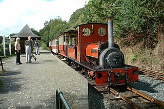
The Launceston Steam Railway is a 1 ft 11 1⁄2 in narrow gauge railway operating from the town of Launceston in Cornwall. The railway is built on the trackbed of the North Cornwall Railway to 1 ft 11 1⁄2 in narrow gauge and runs for 2 1⁄2 miles (4 km) to Newmills, where there is a farm park.

North Cornwall is a constituency represented in the House of Commons of the UK Parliament by Scott Mann, a Conservative since the 2015 general election. Like all British constituencies, the seat elects one Member of Parliament (MP) by the first past the post system of election at least every five years. The seat was created in 1918. Since 1950, the constituency has been held by MPs from either the Conservative Party or the Liberal Democrats.
St Clether is a civil parish and village in Cornwall, England, United Kingdom. The village is situated on the east flank of Bodmin Moor approximately eight miles (13 km) west of Launceston in the valley of the River Inny. The population of the civil parish at the 2011 census was 156.
Launceston Football Club is a football club based in Launceston, Cornwall, England. They are currently members of the South West Peninsula League Premier Division West and play at Pennygillam.

Polyphant, recorded as Polefant c. 1170, is a village in east Cornwall, England, United Kingdom. It is north of the civil parish of Lewannick, five miles (8 km) west of the town of Launceston near the convergence of the River Inny and Penpont Water.
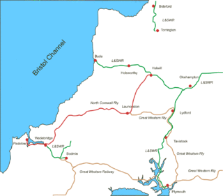
The North Cornwall Railway was a railway line running from Halwill in Devon to Padstow in Cornwall via Launceston, Camelford and Wadebridge, a distance of 49 miles 67 chains (80.21 km). Opened in the last decade of the nineteenth century, it was part of a drive by the London and South Western Railway (LSWR) to develop holiday traffic to Cornwall. The LSWR had opened a line connecting Exeter with Holsworthy in 1879, and by encouraging the North Cornwall Railway it planned to create railway access to previously inaccessible parts of the northern coastal area.
Launceston railway station was situated in Launceston, Cornwall, United Kingdom. It was served by both the Great Western Railway (GWR) and London and South Western Railway (LSWR).

Werrington is a civil parish and former manor now in Cornwall, England, United Kingdom. Prior to boundary changes it straddled the Tamar and lay within the county of Devon. The portion on the west side was transferred to Cornwall in 1966. It is situated 1 mile (1.6 km) to the west of the Tamar, the traditional boundary between Devon and Cornwall, and 1 mile (1.6 km) north of Launceston.
Linkinhorne is a civil parish and village in southeast Cornwall, England, United Kingdom. The village itself is situated at grid reference SX 320 736 and is approximately four miles (6.5 km) northwest of Callington and seven miles (11 km) south of Launceston. The parish population at the 2011 census including Downgate was 1,541

The River Inny is a small river in east Cornwall, United Kingdom. It is a tributary of the River Tamar and is about twenty miles (32 km) long from its source near Davidstow on the eastern flank of Bodmin Moor to its confluence with the Tamar at Inny Foot near Dunterton.

St Stephens by Launceston Rural is a civil parish in the east of Cornwall, England, United Kingdom. It is in the Registration district of Launceston. The population of the parish in the 2001 census was 312, increasing to 360 and including Dutson at the 2011 census. The former parish of St Stephens by Launceston was abolished in 1894: St Stephens by Launceston Urban became part of the town of Launceston, while St Stephens by Launceston Rural became part of Launceston Rural District.

The River Ottery is a small river in northeast Cornwall, United Kingdom. The river is about twenty miles (32 km) long from its source southeast of Otterham to its confluence with the River Tamar at Nether Bridge, two miles (3.2 km) northeast of Launceston.

Connon is a hamlet near Liskeard in Cornwall, England. Connon is in the civil parish of St Pinnock.
Crow's Nest is a village in Cornwall, England, UK. It is located within the civil parish of St Cleer, on the southeastern edge of Bodmin Moor, 3 miles (4.8 km) north of the town of Liskeard.
Forder is a village near Saltash in Cornwall, England.

Pempwell is a hamlet near Stoke Climsland in Cornwall, England, UK.
Launceston Rural District was a local government division of Cornwall between 1894 and 1974. Established under the Local Government Act 1894, the rural district was enlarged in 1966 by the abolition of Broadwoodwidger Rural District, in Devon, to include the civil parishes of North Petherwin and Werrington.

The River Kensey is a river in east Cornwall, England, UK which is a tributary of the River Tamar.

The River Seaton is a river in east Cornwall, England, UK which flows southwards for 11 miles (17 km) into the English Channel.

The River Lerryn is a river in east Cornwall, England, UK, a tributary of the River Fowey. The Lerryn is the largest of the tributaries which enter the estuary of the Fowey. The river is tidal up to the village of Lerryn. The landscape of the Lerryn catchment is rural and includes heathland, moorland and rough pasture in the upper reaches and broadleaf, coniferous and mixed plantation woodland in the lower. This catchment includes four SSSIs, including Redlake Meadows & Hoggs Moor. The Lerryn rises at Fairy Cross on the southern slopes of Bodmin Moor and flows south-southwest until it enters the Fowey estuary.
| Unitary authorities | |
|---|---|
| Major settlements |
|
| Rivers | |
| Topics | |
Coordinates: 50°38′56″N4°20′56″W / 50.649°N 4.349°W
| This Cornwall location article is a stub. You can help Wikipedia by expanding it. |