Dyess Army Airfield

Last updated

Dyess Army Airfield
Part of Ronald Reagan Ballistic Missile Defense Test Site
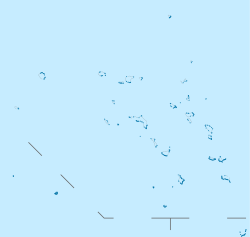
Roi-Namur, Kwajalein Atoll in  Marshall Islands
Dyess Army Airfield.png
Roi & Namur Islands - NARA - 100360025.jpg
The installation on a 1944 map
Marshall Islands location map.svg
Red pog.svg
Dyess AAF
North Pacific location map.svg
Red pog.svg
Dyess AAF
Coordinates 09°23′49″N167°28′15″E / 9.39694°N 167.47083°E / 9.39694; 167.47083
Site information
OwnerFlag of the United States Army.svg  United States Army
Airfield information
Identifiers ICAO: PKRO, FAA LID: ROI
Elevation10 feet (3 m) AMSL
Runways
Direction Length and surface
04/224,499 feet (1,371 m) Paved
Source: Federal Aviation Administration [1]

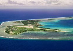
Dyess Army Airfield (ICAO : PKRO, FAA LID : ROI, [2] also known as Freeflight International Airport)[ citation needed ] is a military airfield on Roi-Namur, Kwajalein Atoll, Marshall Islands. It is owned by the United States Army. [1] Approximately 60 U.S. personnel reside on the base, with an additional 100 personnel commuting from Bucholz Army Airfield daily by plane. [3]

Contents

History

When the Japanese took control of the island during World War II they built an airfield that took the form of the number "4." After the 4th Marine Division landed the Seabees of 3rd Battalion, 20th Marines and the 109th Naval Construction Battalion made the field operational again. The Japanese designated the runways A, B, and C, with A being the vertical leg, B being the diagonal and C intersecting at a right angle to A. The Seabees of the Naval Base Kwajalein repaired runways A and C. Today the only runway that remains is A.

On September 19, 1950, the Marshall Islands' worst aviation accident happened near Dyess. A Douglas R5D-3 (56496) of the US Navy crashed into the Pacific shortly after takeoff from runway 07 on what was supposed to be a flight to Tokyo, killing all 26 onboard. [4]

Facilities

Dyess Army Airfield is at an elevation of 10 feet (3 m) above mean sea level. The runway is designated 04/22 with an asphalt surface measuring 4,499 by 150 feet (1,371 x 45.5 m). [1]

Related Research Articles

<span class="mw-page-title-main">Kwajalein Atoll</span> Atoll in the Marshall Islands

Kwajalein Atoll is part of the Republic of the Marshall Islands (RMI). The southernmost and largest island in the atoll is named Kwajalein Island, which its majority English-speaking residents often use the shortened name, Kwaj. The total land area of the atoll amounts to just over 6 square miles (16 km2). It lies in the Ralik Chain, 2,100 nautical miles southwest of Honolulu, Hawaii.

<span class="mw-page-title-main">Battle of Kwajalein</span> 1944 battle in the Pacific theater of World War II

The Battle of Kwajalein was fought as part of the Pacific campaign of World War II. It took place 31 January – 3 February 1944, on Kwajalein Atoll in the Marshall Islands. Employing the hard-learned lessons of the Battle of Tarawa, the United States launched a successful twin assault on the main islands of Kwajalein in the south and Roi-Namur in the north. The Japanese defenders put up stiff resistance, although outnumbered and under-prepared. The determined defense of Roi-Namur left only 51 survivors of an original garrison of 3,500.

<span class="mw-page-title-main">Henderson Field (Midway Atoll)</span> Public airport on Sand Island in Midway Atol

Henderson Field is a public airport located on Sand Island in Midway Atoll, an unincorporated territory of the United States. The airport is used as an emergency diversion point for ETOPS operations. It is one of three airfields named after Major Lofton R. Henderson, together with Henderson Field on Midway's Eastern Island, and Henderson Field in the Solomon Islands. The airfield now provides access to Midway Atoll National Wildlife Refuge.

<span class="mw-page-title-main">Bonriki International Airport</span> Airport in Bonriki, South Tarawa

Bonriki International Airport is an international airport in Kiribati, serving as the main gateway to the country. It is located in its capital, South Tarawa, which is a group of islets in the atoll of Tarawa in the Gilbert Islands, precisely on Bonriki.

<span class="mw-page-title-main">Funafuti International Airport</span> Airport in Funafuti Atoll, Tuvalu

Funafuti International Airport is an airport in Funafuti, in the capital city of the island nation of Tuvalu. It is the sole international airport in Tuvalu. Fiji Airways operates between Suva and Funafuti.

<span class="mw-page-title-main">Bucholz Army Airfield</span> Airport in Kwajalein

Bucholz Army Airfield is a United States Army airfield located on Kwajalein Atoll, Marshall Islands. Its position is ideal for refueling during trans-Pacific flights, and the airport is available to civilians through Air Marshall Islands and United Airlines.

<span class="mw-page-title-main">Naval Air Station Barbers Point</span>

Naval Air Station Barbers Point, on O'ahu, also called John Rodgers Field, is a former United States Navy airfield closed in 1999, and renamed Kalaeloa Airport. Parts of the former air station serve as a film and television studio for the Hawaii State Film Office.

Abemama Airport is the airport serving Abemama, Kiribati. It is located on the north of the atoll, 200 meters northeast of the village of Tabiang.

<span class="mw-page-title-main">French Frigate Shoals Airport</span> Airport

French Frigate Shoals Airport is a private use airport on Tern Island in French Frigate Shoals, a coral atoll, in Hawaii, United States. It is owned by the United States Fish and Wildlife Service, as part of the Hawaiian Islands National Wildlife Refuge.

<span class="mw-page-title-main">Casco Cove Coast Guard Station</span> Airport in Attu Island, Alaska

Casco Cove Coast Guard Station was a military facility and private use airfield on Attu Island, one of the Aleutian Islands in the U.S. state of Alaska. Owned by the United States Coast Guard, Casco Cove CGS is located 1,481 miles (2,383 km) west of Anchorage, Alaska. Also known as LORAN Station Attu, the facility was closed on August 27, 2010, but the airfield remains available for emergency use.

<span class="mw-page-title-main">Majuro Airfield</span>

Majuro Airfield or Naval Air Facility Majuro (NAF Majuro) is a former World War II airfield on the island of Delap in the Marshall Islands. The facility was supported by a large base, Naval Base Majuro.

<span class="mw-page-title-main">Johnston Atoll Airport</span> Airport on Johnson Atoll

Johnston Atoll Airport is located on the Johnston Atoll in the United States Minor Outlying Islands, in the Pacific Ocean 717 nautical miles southwest of Hawaii. It was an active U.S. military facility during the 20th century, but the airport was shut down in 2005 and the runway is not maintained. Although no longer a diversion airport, it is still considered preferable to a dangerous water landing in an extreme emergency.

<span class="mw-page-title-main">US Naval Advance Bases</span> Overseas US Naval Bases

US Naval Advance Bases were built globally by the United States Navy during World War II to support and project U.S. naval operations worldwide. A few were built on Allied soil, but most were captured enemy facilities or completely new. Advance bases provided the fleet with support to keep ships tactically available with repair and supply depots of facilities, rather than return them to the continental United States. Before Japan declared war on the United States the U.S. Navy had a single fleet-sized advanced base in the Territory of Hawaii at Naval Station Pearl Harbor. During the war the U.S. Navy Seabees built over 400 advance bases categorized by size. Naval bases were either Lions or Cubs while airfields were either Oaks or Acorns. Lions and Oaks were major facilities while Cubs and Acorns were minor. PT Boats typically would get a Cub and airfields with single runways were Acorns. The larger bases could do refueling and overhaul; loading of troopship and cargo ships; and preparing amphibious assault ships. Some became major repair depots. The Seabees developed auxiliary floating drydocks were able to repair battle damage and do regular maintenance in the field saving ships trans-pacific trips for repair. A few bases also were developed to be R and R for all U.S. personnel. Most Advance Bases were built by the US Navy's Seabees in Naval Construction Battalions (CBs). At the start of the war civilian contractors were employed in construction. The Seabees in World War II built most of the airfields used by the United States Army Air Forces and United States Marine Corps, as they had the ships and cranes needed to transport the vast amount of equipment needed at the advance bases. The US Army and United States Coast Guard also operated out of many of these facilities. Seabees could build new or repair damaged runways, and with advancements in heavy bomber technology lengthen runways as needed. A few Naval Advance Bases were built for the Korean War and Vietnam War.

<span class="mw-page-title-main">Naval Advance Base Saipan</span> World War II base

Naval Base Saipan or Naval Advance Base Saipan or Naval Air Base Saipan was a United States Navy Naval base built during World War II to support Pacific Ocean theater of war and the many warships and troops fighting the war. The base was on the island of Saipan in the Northern Mariana Islands. The base was part of the Pacific island hopping campaign. The base construction started after the Battle of Saipan ended on July 9, 1944. US Naval Advance Base Saipan was constructed by the Seabees Naval Mobile Construction Battalions. The base was under the Commander Naval Forces Marianas. Saipan is 12 miles (19 km) long and 5 miles (8.0 km) wide. About 70% of the island was sugarcane cultivation at the start of the base construction. At the start of the Battle of Saipan, the island's population had about 30,000 Japanese troops and about 20,000 Japanese civilians. The city of Garapan was the administrative center for the Saipan governmental district.

<span class="mw-page-title-main">Tinian Naval Base</span> Major World War 2 base

Tinian Naval Base and Naval Air Facility Tinian was a major United States Navy sea and air base on Tinian Island, part of the Northern Mariana Islands on the east side of the Philippine Sea in the Pacific Ocean. The base was built during World War II to support the many bombers and aircraft fighting and patrolling in the South West Pacific theatre of the Pacific War. Numerous naval facilities were built on the entire island of 101.22 km. The main port was built at the city and port of San Jose, also called Tinian Harbor. All construction was done by the Navy's Seabees Sixth Construction Brigade with minor help from the 64th Army Engineers, including the main two airports: West Field and North Field. United States Army Air Forces operated long-range bombers out of the air base built and maintained by the Seabees. The base was decommissioned on 1 June 1947.

<span class="mw-page-title-main">Naval Base Abemama</span> Former naval base of the United States

Naval Base Abemama was a naval base built by the United States Navy in 1943 to support the World War II effort. The base was located on Abemama atoll, also called Hopper Atoll, in the Gilbert Islands in the Central Pacific Ocean. The base was built as one of many advance bases in the island-hopping campaign towards the Empire of Japan. At Naval Base Abemama the Navy built a seaport and airbase. Construction started after the Battle of Abemama ended November 24, 1943, part of Operation Galvanic.

<span class="mw-page-title-main">Naval Base Kwajalein</span> Main World War II Naval Base in Marshall Islands

Naval Base Kwajalein was United States Navy base built on Kwajalein Atoll, in the Marshall Islands to support the World War II efforts in the Pacific War. The base was built after the Battle of Kwajalein ended 3 February 1944. The US Navy built airfields, a seaport and a craft repair depot on the captured islands. The base was part of the vast Naval Base Marshall Islands.

<span class="mw-page-title-main">Naval Base Majuro</span> Main World War II Naval Base in Marshall Islands

Naval Base Majuro was a major United States Navy base built on Majuro Atoll, in the Marshall Islands to support the World War II efforts in the Pacific War. The base was built after the Battle of Majuro-Kwajalein ended 3 February 1944. Majuro was found to be unoccupied and abandoned when the United States Army arrived. The US Navy built airfields, seaport, and other facilities on the captured islands. The base was part of the vast Naval Base Marshall Islands.

<span class="mw-page-title-main">Naval Base Marshall Islands</span> Major World War II Naval Bases in Marshall Islands

Naval Base Marshall Islands were United States Navy advance bases built on the Marshall Islands during World War II to support the Pacific War efforts. The bases were built by US Navy after the Marshall Islands campaign that captured the islands from the Empire of Japan. By February 1944 the United States Armed Forces had captured the islands. Most of the airfields and other facilities Japan had built were destroyed in allied bombing raids and naval bombardment. US Navy Seabee Construction Battalions arrived as soon as the area was secured and remove the debris. The Seabees quickly repaired, built and improved the airfield/runways and seaport. Seabees often worked around the clock to get airfields operational so that fighter aircraft and bombers could start operating. The bases were used for staging upcoming campaigns and for repair.

References

  1. 1 2 3 FAA Airport Form 5010 for ROI PDF , retrieved 18 August 2022.
  2. DoD Flight Information Publication (Enroute) - Supplement Pacific, Australasia and Antarctica. St. Louis, Missouri: National Geospatial-Intelligence Agency. 2005. p. B-77.
  3. USAG-KA Public Affairs Office (2021). "Welcome to U.S. Army Garrison-Kwajalein Atoll". p. 54. Retrieved 18 August 2022.
  4. "ASN Aircraft accident Douglas R5D-3 (DC-4) 56496 Kwajalein NAS (KWA)". aviation-safety.net. Retrieved 21 February 2023.