
In archaeology, a broch is an Iron Age drystone hollow-walled structure found in Scotland. Brochs belong to the classification "complex Atlantic roundhouse" devised by Scottish archaeologists in the 1980s.

Peel is a seaside town and small fishing port in the Isle of Man, in the historic parish of German but administered separately. Peel is the third largest town in the island after Douglas and Ramsey but the fourth largest settlement, as Onchan has the second largest population but is classified as a village.

The Isle of Mull or just Mull is the second-largest island of the Inner Hebrides and lies off the west coast of Scotland in the council area of Argyll and Bute.

Kintyre is a peninsula in western Scotland, in the southwest of Argyll and Bute. The peninsula stretches about 30 miles, from the Mull of Kintyre in the south to East and West Loch Tarbert in the north. The region immediately north of Kintyre is known as Knapdale.

Ulva is a small island in the Inner Hebrides of Scotland, off the west coast of Mull. It is separated from Mull by a narrow strait, and connected to the neighbouring island of Gometra by a bridge. Much of the island is formed from Cenozoic basalt rocks, which are formed into columns in places.
The Treshnish Isles are an archipelago of small islands and skerries, lying west of the Isle of Mull, in Scotland. They are part of the Inner Hebrides. Trips to the Treshnish Isles operate from Ulva Ferry, Tobermory, Ardnamurchan and Tiree.
Calgary is a hamlet on the northwest coast of the Isle of Mull, in Argyll and Bute, Scotland, United Kingdom. The hamlet is within the parish of Kilninian and Kilmore. It was the origin of the name of Fort Calgary in Canada, which became the city of Calgary, Alberta.

Saddell is a small Scottish village situated on the east side of the Kintyre Peninsula of Argyll and Bute, overlooking the Kilbrannan Sound and the Isle of Arran, 8 miles (13 km) from Campbeltown on the B842 road to Carradale. The name Saddell is derived from the Norse for sandy dale.

Dunvegan is a village on the Isle of Skye in Scotland. It is famous for Dunvegan Castle, seat of the chiefs of Clan MacLeod. Dunvegan is within the parish of Duirinish, and Duirinish Parish Church is at Dunvegan. In 2011 it had a population of 386.

Dunstaffnage Castle is a partially ruined castle in Argyll and Bute, western Scotland. It lies 3 miles (5 km) NNE of Oban, situated on a platform of conglomerate rock on a promontory at the south-west of the entrance to Loch Etive, and is surrounded on three sides by the sea. The castle and the nearby chapel ruin have been a Historic Scotland property since 1958. Both are Scheduled Ancient Monuments.

Lorne is an ancient province in the west of Scotland, which is now a district in the Argyll and Bute council area. The district gives its name to the Lynn of Lorn National Scenic Area, one of forty such areas in Scotland, which have been defined so as to identify areas of exceptional scenery and to ensure its protection from inappropriate development. The national scenic areas cover 15,726 ha, of which 10,088 ha are marine seascape, and includes the whole of the island of Lismore, along with neighbouring areas on the mainland such as Benderloch and Port Appin, and the Shuna Island.

Dùn Èistean is a multi-period archaeological site on an inter-tidal sea stack on the north east coast of the Isle of Lewis, near the village of Knockaird in the area of Nis (Ness) in the Western Isles of Scotland. It is accorded the status of traditional stronghold of Clan Morrison, once a highly powerful family within the Lordship of the Isles, in local oral tradition. The ruins of two large buildings and groups of interconnecting cellular structures can be seen amongst the grassy tussocks on the top of the island, as well as an artificial pond and a low turf wall enclosing the site. The most prominent feature of the site is a large circular mound of rubble situated on the highest point of the stack, on the north east side of the site. The topographical survey of the site shows these buildings.

Caisteal Maol is a ruined castle located near the harbour of the village of Kyleakin, Isle of Skye, Scotland. It is also known as Castle Moil, Castle Maol, Dun Akyn, Dunakin CastleDun Haakon and Castle Dunakin.
Kirkmaiden is a parish in the Rhins of Galloway, the most southerly in Scotland; the present Church of Scotland parish has the same name as and is approximately coterminous with the original pre-Reformation parish.
Lochaline is the main village in the Morvern area of Highland, Scotland. The coastal village is situated at the mouth of Loch Aline, on the northern shore of the Sound of Mull. A ferry operates regularly over to Fishnish on the Isle of Mull.
Port of Ness is a village on the Isle of Lewis in the community of Ness, in the Outer Hebrides, Scotland. Port of Ness is within the parish of Barvas. Port of Ness is situated at the end of the A857, which runs from Stornoway. In 2014, the Ness Fishery Memorial was erected to celebrate the fishing heritage in the area and to commemorate the 96 people who lost their lives in the industry between 1835 and 1900.

Harlosh is a settlement on the island of Skye off the west coast of Scotland. The settlement is on a peninsula of the same name.

Dùn an Achaidh, sometimes Anglicised as Dun Acha, is a dun located near the village of Acha on the Inner Hebridean island of Coll. It is considered the best preserved dun on the island. The site of Dùn an Achaidh is located at grid reference NM18335456. According to local tradition, the dun was the stronghold of, and named after, the son of a Norse king. The early 20th century antiquary Erskine Beveridge considered it as one of the four most interesting fortifications on Coll.

Rubha an Dùnain or Rubh' an Dùnain is an uninhabited peninsula to the south of the Cuillin hills on the Isle of Skye in Scotland. It contains unique archaeological sites which in 2017 were designated as a historic monument of national importance by Historic Environment Scotland.
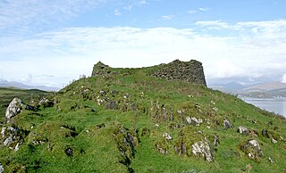
Tirefour Castle, is an Iron Age broch located 4 kilometres north of Achnacroish on the island of Lismore, Scotland.


