
Loreauville is a village in Iberia Parish in the U.S. state of Louisiana. The population was 887 at the 2010 census, down from 938 at the 2000 census. It is part of the New Iberia micropolitan statistical area, and the Lafayette metropolitan statistical area.

New Iberia is the largest city in and parish seat of Iberia Parish in the U.S. state of Louisiana. The city of New Iberia is located approximately 21 miles southeast of Lafayette, and forms part of the Lafayette metropolitan statistical area in the region of Acadiana. The 2020 United States census tabulated a population of 28,555. New Iberia is served by Amtrak’s Sunset Limited, operating between Los Angeles and New Orleans. New Iberia has a major four lane highway, being U.S. 90, and has its own general aviation airfield, Acadiana Regional Airport. Scheduled passenger and cargo airline service is available via the nearby Lafayette Regional Airport located adjacent to U.S. 90 in Lafayette.

St. Martinville is a city in and the parish seat of St. Martin Parish, Louisiana, United States. It lies on Bayou Teche, 13 miles (21 km) south of Breaux Bridge, 16 miles (26 km) southeast of Lafayette, and 9 miles (14 km) north of New Iberia. The population was 6,114 at the 2010 U.S. census, and 5,379 at the 2020 United States census. It is part of the Lafayette metropolitan statistical area.

Franklin is a small city in and the parish seat of St. Mary Parish, Louisiana, United States. The population was 7,660 at the 2010 census. The city is located on Bayou Teche, southeast of the cities of Lafayette, 47 miles (76 km) and New Iberia, 28 miles (45 km), and 22 miles (35 km) northwest of Morgan City. It is part of the Morgan City Micropolitan Statistical Area and the larger Lafayette-Acadiana combined statistical area.
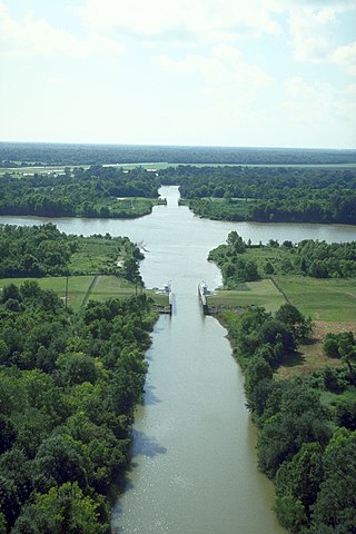
Bayou Teche is a 125-mile-long (201 km) waterway in south central Louisiana in the United States. Bayou Teche was the Mississippi River's main course when it developed a delta about 2,800 to 4,500 years ago. Through a natural process known as deltaic switching, the river's deposits of silt and sediment cause the Mississippi to change its course every thousand years or so.

Jungle Gardens is a 170-acre (0.69 km2) botanical garden and bird sanctuary located on Avery Island, Louisiana. Jungle Gardens is open every day of the year, except major holidays. An admission fee is charged.

Shadows-on-the-Teche is an American 3,750 square feet (348 m2) historic house, garden, and cemetery. Formerly a working sugar cane plantation with enslaved labor, it is located in New Iberia, Louisiana, United States. Built in 1834 for planter, David Weeks (1786–1834) and his wife Mary Conrad Weeks (1797–1863). The property is also home to the Shadows-on-the-Teche cemetery.
The Moscow-Pullman Daily News is a daily newspaper in the northwestern United States, serving the Moscow, Idaho, and Pullman, Washington, metropolitan area. The two cities on the Palouse are the homes of the two states' land grant universities, the University of Idaho and Washington State University.
Main Street is a major north–south thoroughfare in Los Angeles, California. It serves as the east–west postal divider for the city and the county as well.
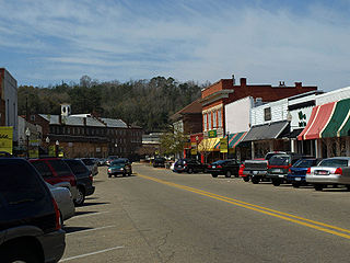
The Daniel Pratt Historic District is a historic district that includes 140 acres (57 ha) and 154 buildings in Prattville, Alabama. It is named in honor of Prattville's founder, Daniel Pratt. The district includes the historic downtown and is roughly bounded by 6th Street in the north, Northington Street in the east, 1st Street in the south, and Bridge and Court streets in the west. Architecture in the district includes the Greek Revival, Italianate, and Bungalow styles. It was listed on the National Register of Historic Places on August 30, 1984.
Louisiana Highway 86 (LA 86) is a state highway located in southern Louisiana. It runs 16.42 miles (26.43 km) in a general north–south direction from LA 182 in New Iberia to LA 31 north of town.

Louisiana Highway 87 (LA 87) is a state highway located in southern Louisiana. It runs 42.04 miles (67.66 km) in a northwest to southeast direction from LA 86 in New Iberia to the junction of two local roads north of Centerville.

Louisiana Highway 96 (LA 96) is a state highway located in southern Louisiana. It runs 19.54 miles (31.45 km) in an east–west direction from LA 182 in Broussard to LA 352 east of Catahoula.

The Conrad Rice Mill is an independently owned and operated rice mill located in New Iberia, Louisiana, and produces the Konriko brand of rice varieties. Established in 1912, it is the oldest independently owned rice mill in the United States still in operation.
The Dulcito Plantation is a historic house built c. 1850, and formally was a Southern sugar plantation, located at 5918 West Old Spanish Trail near New Iberia, Louisiana. This is one of the few remaining buildings of the area that highlights the pre-Civil War architectural heritage, despite having some alterations. The house was listed on the National Register of Historic Places on July 22, 1994.

The Carville Historic District in Carville, Louisiana, is a 60-acre (24 ha) historic district that was listed on the National Register of Historic Places on November 18, 1992. It formerly served as a treatment facility for leprosy, and was called the National Leprosarium, Gillis W. Long Hansen's Disease Center and Public Health Service Hospital No. 66.
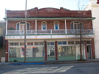
Main Street Historic District is a historic district in downtown Baton Rouge, Louisiana, United States, located along Main Street, from North 4th Street to North 7th Street.

Plaquemine Historic District is a historic district in downtown Plaquemine, Louisiana, United States, located along Railroad Avenue, Main Street, Eden Street, Church Street, Plaquemine Street and Court Street.
The Main Street Historic District is a historic district located along East Main Street in Broussard, Louisiana, United States.
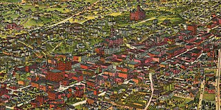
The late-Victorian-era Downtown of Los Angeles in 1880 was centered at the southern end of the Los Angeles Plaza area, and over the next two decades, it extended south and west along Main Street, Spring Street, and Broadway towards Third Street. Most of the 19th-century buildings no longer exist, surviving only in the Plaza area or south of Second Street. The rest were demolished to make way for the Civic Center district with City Hall, numerous courthouses, and other municipal, county, state and federal buildings, and Times Mirror Square. This article covers that area, between the Plaza, 3rd St., Los Angeles St., and Broadway, during the period 1880 through the period of demolition (1920s–1950s).


